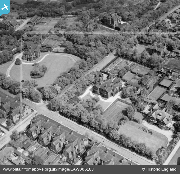
EAW006183 ENGLAND (1947). Hartford Grange and Hartford House, Werneth, 1947. This image was marked by Aerofilms Ltd for photo editing.
© Copyright OpenStreetMap contributors and licensed by the OpenStreetMap Foundation. 2026. Cartography is licensed as CC BY-SA.
Nearby Images (13)
Details
| Title | [EAW006183] Hartford Grange and Hartford House, Werneth, 1947. This image was marked by Aerofilms Ltd for photo editing. |
| Reference | EAW006183 |
| Date | 25-May-1947 |
| Link | |
| Place name | WERNETH |
| Parish | |
| District | |
| Country | ENGLAND |
| Easting / Northing | 391545, 403681 |
| Longitude / Latitude | -2.1275647020012, 53.529474069293 |
| National Grid Reference | SD915037 |
Pins

eddief |
Tuesday 19th of November 2013 07:54:43 PM | |

eddief |
Tuesday 19th of November 2013 07:53:38 PM | |

eddief |
Tuesday 19th of November 2013 07:52:36 PM | |

eddief |
Tuesday 19th of November 2013 07:51:12 PM | |

eddief |
Tuesday 19th of November 2013 07:49:50 PM | |

eddief |
Tuesday 19th of November 2013 07:48:36 PM |


![[EAW006183] Hartford Grange and Hartford House, Werneth, 1947. This image was marked by Aerofilms Ltd for photo editing.](http://britainfromabove.org.uk/sites/all/libraries/aerofilms-images/public/100x100/EAW/006/EAW006183.jpg)
![[EAW004253] Hartford Grange and environs, Oldham, 1947. This image was marked by Aerofilms Ltd for photo editing.](http://britainfromabove.org.uk/sites/all/libraries/aerofilms-images/public/100x100/EAW/004/EAW004253.jpg)
![[EAW006180] Hartford Grange, Werneth, 1947. This image was marked by Aerofilms Ltd for photo editing.](http://britainfromabove.org.uk/sites/all/libraries/aerofilms-images/public/100x100/EAW/006/EAW006180.jpg)
![[EAW006178] Hartford Grange, Werneth, 1947](http://britainfromabove.org.uk/sites/all/libraries/aerofilms-images/public/100x100/EAW/006/EAW006178.jpg)
![[EAW006179] Hartford Grange, Werneth, 1947. This image was marked by Aerofilms Ltd for photo editing.](http://britainfromabove.org.uk/sites/all/libraries/aerofilms-images/public/100x100/EAW/006/EAW006179.jpg)
![[EPW016034] Werneth Park, Oldham, from the south-east, 1926](http://britainfromabove.org.uk/sites/all/libraries/aerofilms-images/public/100x100/EPW/016/EPW016034.jpg)
![[EAW004250] Hartford Grange, Wellington Road and environs, Oldham, 1947. This image was marked by Aerofilms Ltd for photo editing.](http://britainfromabove.org.uk/sites/all/libraries/aerofilms-images/public/100x100/EAW/004/EAW004250.jpg)
![[EAW004254] Hartford Grange, Wellington Road and environs, Oldham, 1947. This image was marked by Aerofilms Ltd for photo editing.](http://britainfromabove.org.uk/sites/all/libraries/aerofilms-images/public/100x100/EAW/004/EAW004254.jpg)
![[EAW006184] Hartford Grange, Werneth, 1947. This image was marked by Aerofilms Ltd for photo editing.](http://britainfromabove.org.uk/sites/all/libraries/aerofilms-images/public/100x100/EAW/006/EAW006184.jpg)
![[EAW006182] Grange Avenue, Hartford House and Hartford Grange, Werneth, 1947. This image was marked by Aerofilms Ltd for photo editing.](http://britainfromabove.org.uk/sites/all/libraries/aerofilms-images/public/100x100/EAW/006/EAW006182.jpg)
![[EAW004251] Hartford Grange, Wellington Road and environs, Oldham, 1947](http://britainfromabove.org.uk/sites/all/libraries/aerofilms-images/public/100x100/EAW/004/EAW004251.jpg)
![[EAW004252] Hartford Grange, Wellington Road, Selkirk Avenue and environs, Oldham, 1947. This image was marked by Aerofilms Ltd for photo editing.](http://britainfromabove.org.uk/sites/all/libraries/aerofilms-images/public/100x100/EAW/004/EAW004252.jpg)
![[EAW006181] Wellington Road and Hartford Grange, Werneth, 1947. This image was marked by Aerofilms Ltd for photo editing.](http://britainfromabove.org.uk/sites/all/libraries/aerofilms-images/public/100x100/EAW/006/EAW006181.jpg)