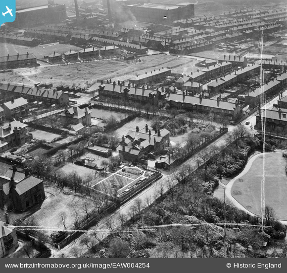
EAW004254 ENGLAND (1947). Hartford Grange, Wellington Road and environs, Oldham, 1947. This image was marked by Aerofilms Ltd for photo editing.
© Copyright OpenStreetMap contributors and licensed by the OpenStreetMap Foundation. 2026. Cartography is licensed as CC BY-SA.
Nearby Images (13)
Details
| Title | [EAW004254] Hartford Grange, Wellington Road and environs, Oldham, 1947. This image was marked by Aerofilms Ltd for photo editing. |
| Reference | EAW004254 |
| Date | 9-April-1947 |
| Link | |
| Place name | OLDHAM |
| Parish | |
| District | |
| Country | ENGLAND |
| Easting / Northing | 391563, 403658 |
| Longitude / Latitude | -2.1272925080074, 53.529267602601 |
| National Grid Reference | SD916037 |
Pins

eddief |
Monday 30th of September 2013 04:34:59 PM | |

eddief |
Monday 30th of September 2013 04:30:26 PM | |

eddief |
Monday 30th of September 2013 04:28:40 PM | |

eddief |
Monday 30th of September 2013 04:24:53 PM | |

eddief |
Monday 30th of September 2013 04:23:55 PM | |

eddief |
Monday 30th of September 2013 04:23:17 PM | |

eddief |
Monday 30th of September 2013 04:02:41 PM | |

eddief |
Monday 30th of September 2013 04:02:09 PM | |

eddief |
Monday 30th of September 2013 04:01:39 PM | |

eddief |
Monday 30th of September 2013 04:01:07 PM | |

eddief |
Monday 30th of September 2013 04:00:39 PM |


![[EAW004254] Hartford Grange, Wellington Road and environs, Oldham, 1947. This image was marked by Aerofilms Ltd for photo editing.](http://britainfromabove.org.uk/sites/all/libraries/aerofilms-images/public/100x100/EAW/004/EAW004254.jpg)
![[EAW006179] Hartford Grange, Werneth, 1947. This image was marked by Aerofilms Ltd for photo editing.](http://britainfromabove.org.uk/sites/all/libraries/aerofilms-images/public/100x100/EAW/006/EAW006179.jpg)
![[EAW006178] Hartford Grange, Werneth, 1947](http://britainfromabove.org.uk/sites/all/libraries/aerofilms-images/public/100x100/EAW/006/EAW006178.jpg)
![[EAW004250] Hartford Grange, Wellington Road and environs, Oldham, 1947. This image was marked by Aerofilms Ltd for photo editing.](http://britainfromabove.org.uk/sites/all/libraries/aerofilms-images/public/100x100/EAW/004/EAW004250.jpg)
![[EAW006180] Hartford Grange, Werneth, 1947. This image was marked by Aerofilms Ltd for photo editing.](http://britainfromabove.org.uk/sites/all/libraries/aerofilms-images/public/100x100/EAW/006/EAW006180.jpg)
![[EAW004253] Hartford Grange and environs, Oldham, 1947. This image was marked by Aerofilms Ltd for photo editing.](http://britainfromabove.org.uk/sites/all/libraries/aerofilms-images/public/100x100/EAW/004/EAW004253.jpg)
![[EAW006183] Hartford Grange and Hartford House, Werneth, 1947. This image was marked by Aerofilms Ltd for photo editing.](http://britainfromabove.org.uk/sites/all/libraries/aerofilms-images/public/100x100/EAW/006/EAW006183.jpg)
![[EPW016034] Werneth Park, Oldham, from the south-east, 1926](http://britainfromabove.org.uk/sites/all/libraries/aerofilms-images/public/100x100/EPW/016/EPW016034.jpg)
![[EAW004252] Hartford Grange, Wellington Road, Selkirk Avenue and environs, Oldham, 1947. This image was marked by Aerofilms Ltd for photo editing.](http://britainfromabove.org.uk/sites/all/libraries/aerofilms-images/public/100x100/EAW/004/EAW004252.jpg)
![[EAW006184] Hartford Grange, Werneth, 1947. This image was marked by Aerofilms Ltd for photo editing.](http://britainfromabove.org.uk/sites/all/libraries/aerofilms-images/public/100x100/EAW/006/EAW006184.jpg)
![[EAW006181] Wellington Road and Hartford Grange, Werneth, 1947. This image was marked by Aerofilms Ltd for photo editing.](http://britainfromabove.org.uk/sites/all/libraries/aerofilms-images/public/100x100/EAW/006/EAW006181.jpg)
![[EAW004251] Hartford Grange, Wellington Road and environs, Oldham, 1947](http://britainfromabove.org.uk/sites/all/libraries/aerofilms-images/public/100x100/EAW/004/EAW004251.jpg)
![[EAW006182] Grange Avenue, Hartford House and Hartford Grange, Werneth, 1947. This image was marked by Aerofilms Ltd for photo editing.](http://britainfromabove.org.uk/sites/all/libraries/aerofilms-images/public/100x100/EAW/006/EAW006182.jpg)