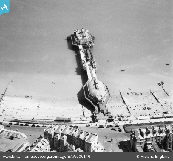
EAW006146 ENGLAND (1947). The pier, Eastbourne, 1947
© Copyright OpenStreetMap contributors and licensed by the OpenStreetMap Foundation. 2026. Cartography is licensed as CC BY-SA.
Nearby Images (13)
Details
| Title | [EAW006146] The pier, Eastbourne, 1947 |
| Reference | EAW006146 |
| Date | 27-May-1947 |
| Link | |
| Place name | EASTBOURNE |
| Parish | |
| District | |
| Country | ENGLAND |
| Easting / Northing | 561846, 98863 |
| Longitude / Latitude | 0.29532423525313, 50.766181823596 |
| National Grid Reference | TV618989 |
Pins

Alan McFaden |
Saturday 9th of November 2013 06:26:47 PM | |
Splendid photographs |

Class31 |
Saturday 9th of November 2013 06:29:13 PM |

Alan McFaden |
Saturday 9th of November 2013 06:26:13 PM | |

Alan McFaden |
Saturday 9th of November 2013 06:25:20 PM | |

Alan McFaden |
Saturday 9th of November 2013 06:24:36 PM | |

Alan McFaden |
Saturday 9th of November 2013 06:24:04 PM |


![[EAW006146] The pier, Eastbourne, 1947](http://britainfromabove.org.uk/sites/all/libraries/aerofilms-images/public/100x100/EAW/006/EAW006146.jpg)
![[EAW022970] The town, Eastbourne, from the north-east, 1949](http://britainfromabove.org.uk/sites/all/libraries/aerofilms-images/public/100x100/EAW/022/EAW022970.jpg)
![[EPW035324] The pier, Eastbourne, 1931](http://britainfromabove.org.uk/sites/all/libraries/aerofilms-images/public/100x100/EPW/035/EPW035324.jpg)
![[EPW000067] Eastbourne Pier, Eastbourne, 1920](http://britainfromabove.org.uk/sites/all/libraries/aerofilms-images/public/100x100/EPW/000/EPW000067.jpg)
![[EPW035322] The pier and seafront, Eastbourne, 1931](http://britainfromabove.org.uk/sites/all/libraries/aerofilms-images/public/100x100/EPW/035/EPW035322.jpg)
![[EPW000103] The Grand Parade with Royal Sussex Regimental Statue, Eastbourne, 1920](http://britainfromabove.org.uk/sites/all/libraries/aerofilms-images/public/100x100/EPW/000/EPW000103.jpg)
![[EPW000746] The Pier, Eastbourne, 1920](http://britainfromabove.org.uk/sites/all/libraries/aerofilms-images/public/100x100/EPW/000/EPW000746.jpg)
![[EAW022967] The town and Beachy Head, Eastbourne, from the north-east, 1949](http://britainfromabove.org.uk/sites/all/libraries/aerofilms-images/public/100x100/EAW/022/EAW022967.jpg)
![[EPW000099] The Queens Hotel, Eastbourne, 1920](http://britainfromabove.org.uk/sites/all/libraries/aerofilms-images/public/100x100/EPW/000/EPW000099.jpg)
![[EPW000742] Marine Parade, Eastbourne, 1920](http://britainfromabove.org.uk/sites/all/libraries/aerofilms-images/public/100x100/EPW/000/EPW000742.jpg)
![[EPW039403] The Grand Parade, the Pier Music Pavilion and the town, Eastbourne, 1932](http://britainfromabove.org.uk/sites/all/libraries/aerofilms-images/public/100x100/EPW/039/EPW039403.jpg)
![[EPW000743] The Pier, Eastbourne, from the south-west, 1920](http://britainfromabove.org.uk/sites/all/libraries/aerofilms-images/public/100x100/EPW/000/EPW000743.jpg)
![[EPW039415] The Pier, Eastbourne, from the east, 1932](http://britainfromabove.org.uk/sites/all/libraries/aerofilms-images/public/100x100/EPW/039/EPW039415.jpg)


