
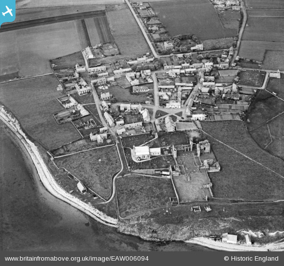
EAW006094 ENGLAND (1947). Lindisfarne Priory and the village, Holy Island, 1947
© Copyright OpenStreetMap contributors and licensed by the OpenStreetMap Foundation. 2026. Cartography is licensed as CC BY-SA.
Nearby Images (16)
EAW006094

EAW034336

EAW034335

EAW034339

EAW006097

EAW034338

EAW034337

EAW006096

EAW007932

EAW007937

EAW007934

EAW007936

EAW006095

EAW034334

EAW007933

EAW007935

Details
| Title | [EAW006094] Lindisfarne Priory and the village, Holy Island, 1947 |
| Reference | EAW006094 |
| Date | 21-May-1947 |
| Link | |
| Place name | HOLY ISLAND |
| Parish | HOLY ISLAND |
| District | |
| Country | ENGLAND |
| Easting / Northing | 412564, 641835 |
| Longitude / Latitude | -1.8002298573769, 55.669864131914 |
| National Grid Reference | NU126418 |
Pins

Chells809 |
Saturday 10th of May 2014 11:39:51 PM | |
|
Chells809 |
Saturday 10th of May 2014 11:38:44 PM | |
|
Chells809 |
Saturday 10th of May 2014 11:37:08 PM | |

melgibbs |
Saturday 14th of December 2013 04:13:43 PM | |
For details on the memorial see www.roll-of-honour.com/Northumberland/Lindisfarne.html. |
melgibbs |
Monday 16th of December 2013 06:42:19 PM |
CORRECTION: The Hough should have been The Heugh. |
melgibbs |
Wednesday 22nd of October 2014 06:57:20 PM |