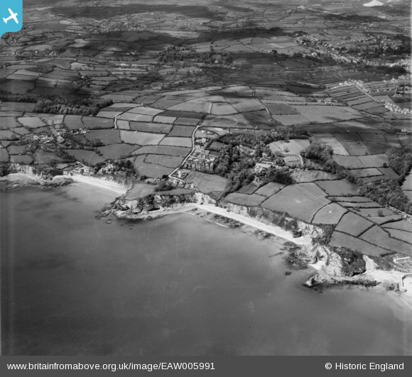
EAW005991 ENGLAND (1947). Duporth Holiday Camp, Duporth Beach and environs, Duporth, 1947
© Copyright OpenStreetMap contributors and licensed by the OpenStreetMap Foundation. 2026. Cartography is licensed as CC BY-SA.
Nearby Images (15)
Details
| Title | [EAW005991] Duporth Holiday Camp, Duporth Beach and environs, Duporth, 1947 |
| Reference | EAW005991 |
| Date | 18-May-1947 |
| Link | |
| Place name | DUPORTH |
| Parish | ST. AUSTELL BAY |
| District | |
| Country | ENGLAND |
| Easting / Northing | 203295, 51029 |
| Longitude / Latitude | -4.7638810886763, 50.325698650546 |
| National Grid Reference | SX033510 |
Pins

redmist |
Wednesday 19th of October 2022 07:30:04 PM | |

Matt Aldred edob.mattaldred.com |
Thursday 11th of March 2021 10:58:05 PM | |

Matt Aldred edob.mattaldred.com |
Thursday 11th of March 2021 10:57:42 PM | |

CornwallPhil |
Tuesday 17th of June 2014 12:45:32 AM | |

CornwallPhil |
Tuesday 17th of June 2014 12:44:28 AM | |

CornwallPhil |
Tuesday 17th of June 2014 12:43:42 AM |
User Comment Contributions

CornwallPhil |
Tuesday 17th of June 2014 12:47:48 AM |


![[EAW005991] Duporth Holiday Camp, Duporth Beach and environs, Duporth, 1947](http://britainfromabove.org.uk/sites/all/libraries/aerofilms-images/public/100x100/EAW/005/EAW005991.jpg)
![[EAW011850] Duporth Holiday Camp, St Austell, 1947](http://britainfromabove.org.uk/sites/all/libraries/aerofilms-images/public/100x100/EAW/011/EAW011850.jpg)
![[EAW005993] Duporth Holiday Camp, Duporth, 1947](http://britainfromabove.org.uk/sites/all/libraries/aerofilms-images/public/100x100/EAW/005/EAW005993.jpg)
![[EAW011851] Duporth Holiday Resort and Du Porth Beach, Duporth, 1947](http://britainfromabove.org.uk/sites/all/libraries/aerofilms-images/public/100x100/EAW/011/EAW011851.jpg)
![[EAW005987] Duporth Holiday Camp and Duporth Beach, Duporth, 1947](http://britainfromabove.org.uk/sites/all/libraries/aerofilms-images/public/100x100/EAW/005/EAW005987.jpg)
![[EAW005992] Duporth Holiday Camp, Duporth Beach and environs, Duporth, from the south-east, 1947](http://britainfromabove.org.uk/sites/all/libraries/aerofilms-images/public/100x100/EAW/005/EAW005992.jpg)
![[EAW005990] Duporth Holiday Camp and environs, Duporth, from the north-east, 1947](http://britainfromabove.org.uk/sites/all/libraries/aerofilms-images/public/100x100/EAW/005/EAW005990.jpg)
![[EAW005989] Duporth Holiday Camp and environs, Duporth, 1947](http://britainfromabove.org.uk/sites/all/libraries/aerofilms-images/public/100x100/EAW/005/EAW005989.jpg)
![[EAW005995] Duporth Holiday Camp, Duporth, 1947](http://britainfromabove.org.uk/sites/all/libraries/aerofilms-images/public/100x100/EAW/005/EAW005995.jpg)
![[EAW011854] Duporth Holiday Resort, Duporth, 1947](http://britainfromabove.org.uk/sites/all/libraries/aerofilms-images/public/100x100/EAW/011/EAW011854.jpg)
![[EAW011857] Duporth Holiday Resort including the manor house, Duporth, 1947](http://britainfromabove.org.uk/sites/all/libraries/aerofilms-images/public/100x100/EAW/011/EAW011857.jpg)
![[EAW011855] Duporth Holiday Resort including the manor house, Duporth, 1947](http://britainfromabove.org.uk/sites/all/libraries/aerofilms-images/public/100x100/EAW/011/EAW011855.jpg)
![[EAW011859] Duporth Holiday Resort, Duporth, 1947](http://britainfromabove.org.uk/sites/all/libraries/aerofilms-images/public/100x100/EAW/011/EAW011859.jpg)
![[EAW005985] Duporth Holiday Camp, Duporth, 1947](http://britainfromabove.org.uk/sites/all/libraries/aerofilms-images/public/100x100/EAW/005/EAW005985.jpg)
