
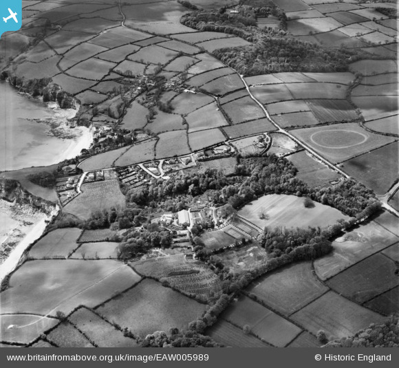
EAW005989 ENGLAND (1947). Duporth Holiday Camp and environs, Duporth, 1947
© Copyright OpenStreetMap contributors and licensed by the OpenStreetMap Foundation. 2026. Cartography is licensed as CC BY-SA.
Nearby Images (19)
EAW005989

EAW011854

EAW011859

EAW005985

EAW005988

EAW011857

EAW011855

EAW005986

EAW011849

EAW011849
EAW005993

EAW011853

EAW005987

EAW005994

EAW005991

EAW011852

EAW011850

EAW011847

EAW011856

Details
| Title | [EAW005989] Duporth Holiday Camp and environs, Duporth, 1947 |
| Reference | EAW005989 |
| Date | 18-May-1947 |
| Link | |
| Place name | DUPORTH |
| Parish | ST. AUSTELL BAY |
| District | |
| Country | ENGLAND |
| Easting / Northing | 203085, 51121 |
| Longitude / Latitude | -4.7668761496913, 50.326455022911 |
| National Grid Reference | SX031511 |
Pins

CornwallPhil |
Thursday 3rd of July 2014 08:34:50 PM | |
|
CornwallPhil |
Thursday 3rd of July 2014 08:33:33 PM | |
|
CornwallPhil |
Thursday 3rd of July 2014 08:31:41 PM |
User Comment Contributions
Various WW2 structures and camps |
CornwallPhil |
Thursday 3rd of July 2014 08:36:08 PM |