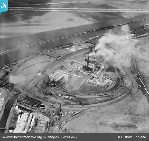
EAW005672 ENGLAND (1947). The Mersey Power Co Electric Power Station, Runcorn, 1947
© Copyright OpenStreetMap contributors and licensed by the OpenStreetMap Foundation. 2026. Cartography is licensed as CC BY-SA.
Nearby Images (17)
Details
| Title | [EAW005672] The Mersey Power Co Electric Power Station, Runcorn, 1947 |
| Reference | EAW005672 |
| Date | 15-May-1947 |
| Link | |
| Place name | RUNCORN |
| Parish | |
| District | |
| Country | ENGLAND |
| Easting / Northing | 349698, 382042 |
| Longitude / Latitude | -2.755438405932, 53.332625686583 |
| National Grid Reference | SJ497820 |
Pins

Bottom Yard |
Sunday 15th of June 2025 11:38:28 AM | |

Bottom Yard |
Wednesday 9th of October 2024 05:49:36 PM |


![[EAW005672] The Mersey Power Co Electric Power Station, Runcorn, 1947](http://britainfromabove.org.uk/sites/all/libraries/aerofilms-images/public/100x100/EAW/005/EAW005672.jpg)
![[EAW005662] The Mersey Power Co Electric Power Station, Runcorn, 1947](http://britainfromabove.org.uk/sites/all/libraries/aerofilms-images/public/100x100/EAW/005/EAW005662.jpg)
![[EAW002741] Percival Lane Power Station, Runcorn, 1946](http://britainfromabove.org.uk/sites/all/libraries/aerofilms-images/public/100x100/EAW/002/EAW002741.jpg)
![[EAW002735] Percival Lane Power Station and Weston Point Salt Works, Runcorn, 1946](http://britainfromabove.org.uk/sites/all/libraries/aerofilms-images/public/100x100/EAW/002/EAW002735.jpg)
![[EAW002740] Percival Lane Power Station, Runcorn, 1946](http://britainfromabove.org.uk/sites/all/libraries/aerofilms-images/public/100x100/EAW/002/EAW002740.jpg)
![[EAW005671] The Mersey Power Co Electric Power Station, Runcorn, 1947](http://britainfromabove.org.uk/sites/all/libraries/aerofilms-images/public/100x100/EAW/005/EAW005671.jpg)
![[EAW005673] The Mersey Power Co Electric Power Station, Runcorn, 1947](http://britainfromabove.org.uk/sites/all/libraries/aerofilms-images/public/100x100/EAW/005/EAW005673.jpg)
![[EAW005668] The Mersey Power Co Electric Power Station, Runcorn, 1947](http://britainfromabove.org.uk/sites/all/libraries/aerofilms-images/public/100x100/EAW/005/EAW005668.jpg)
![[EAW002743] Percival Lane Power Station, Runcorn, 1946](http://britainfromabove.org.uk/sites/all/libraries/aerofilms-images/public/100x100/EAW/002/EAW002743.jpg)
![[EAW002742] Percival Lane Power Station, Runcorn, 1946](http://britainfromabove.org.uk/sites/all/libraries/aerofilms-images/public/100x100/EAW/002/EAW002742.jpg)
![[EAW002738] Percival Lane Power Station, Runcorn, 1946](http://britainfromabove.org.uk/sites/all/libraries/aerofilms-images/public/100x100/EAW/002/EAW002738.jpg)
![[EAW005667] The Mersey Power Co Electric Power Station, Runcorn, 1947](http://britainfromabove.org.uk/sites/all/libraries/aerofilms-images/public/100x100/EAW/005/EAW005667.jpg)
![[EAW016787] The River Mersey and Manchester Ship Canal, Runcorn, 1948](http://britainfromabove.org.uk/sites/all/libraries/aerofilms-images/public/100x100/EAW/016/EAW016787.jpg)
![[EAW002739] Percival Lane Power Station, Runcorn, 1946](http://britainfromabove.org.uk/sites/all/libraries/aerofilms-images/public/100x100/EAW/002/EAW002739.jpg)
![[EAW005664] The Mersey Power Co Electric Power Station alongside the Manchester Ship Canal, Runcorn, 1947. This image was marked by Aerofilms Ltd for photo editing.](http://britainfromabove.org.uk/sites/all/libraries/aerofilms-images/public/100x100/EAW/005/EAW005664.jpg)
![[EAW002736] Percival Lane Power Station and the Manchester Ship Canal, Runcorn, 1946](http://britainfromabove.org.uk/sites/all/libraries/aerofilms-images/public/100x100/EAW/002/EAW002736.jpg)
![[EAW005663] The Mersey Power Co Electric Power Station alongside the Manchester Ship Canal, Runcorn, 1947. This image was marked by Aerofilms Ltd for photo editing.](http://britainfromabove.org.uk/sites/all/libraries/aerofilms-images/public/100x100/EAW/005/EAW005663.jpg)