
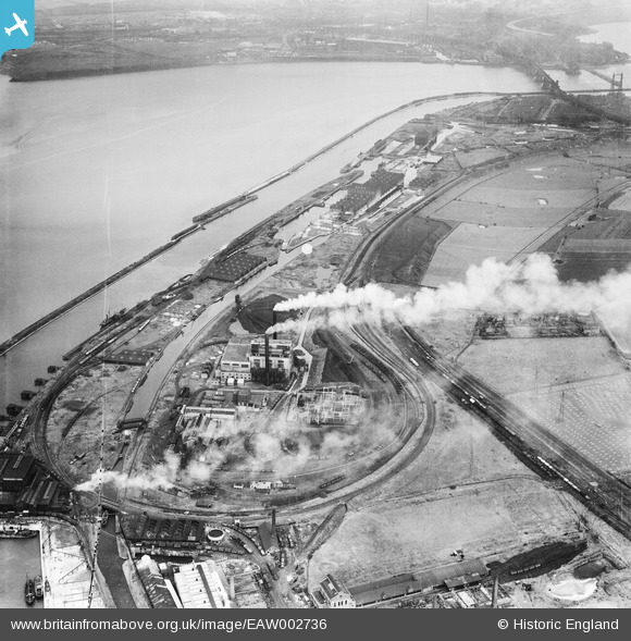
EAW002736 ENGLAND (1946). Percival Lane Power Station and the Manchester Ship Canal, Runcorn, 1946
© Copyright OpenStreetMap contributors and licensed by the OpenStreetMap Foundation. 2026. Cartography is licensed as CC BY-SA.
Nearby Images (11)
EAW002736

EAW005663

EAW005664

EAW005667

EAW005668

EAW005671

EAW002740

EAW005672

EAW005662

EAW002741

EAW002735

Details
| Title | [EAW002736] Percival Lane Power Station and the Manchester Ship Canal, Runcorn, 1946 |
| Reference | EAW002736 |
| Date | 11-September-1946 |
| Link | |
| Place name | RUNCORN |
| Parish | |
| District | |
| Country | ENGLAND |
| Easting / Northing | 349888, 382247 |
| Longitude / Latitude | -2.7526176824393, 53.334486447921 |
| National Grid Reference | SJ499822 |
Pins

Bottom Yard |
Sunday 15th of June 2025 11:10:59 AM | |
|
Bottom Yard |
Sunday 15th of June 2025 11:09:36 AM | |
|
HAP_Weston |
Friday 6th of June 2025 08:03:35 PM | |
|
Bottom Yard |
Tuesday 8th of October 2024 10:25:23 AM | |
|
Bottom Yard |
Tuesday 8th of October 2024 10:18:19 AM | |
|
redmist |
Wednesday 26th of December 2018 10:31:26 AM | |
|
redmist |
Wednesday 26th of December 2018 10:29:12 AM | |
|
redmist |
Wednesday 26th of December 2018 10:18:25 AM | |
|
redmist |
Wednesday 26th of December 2018 10:16:17 AM |