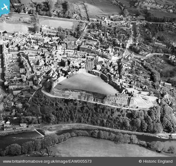
EAW005573 ENGLAND (1947). The castle and town centre, Richmond, 1947
© Copyright OpenStreetMap contributors and licensed by the OpenStreetMap Foundation. 2026. Cartography is licensed as CC BY-SA.
Nearby Images (22)
Details
| Title | [EAW005573] The castle and town centre, Richmond, 1947 |
| Reference | EAW005573 |
| Date | 17-May-1947 |
| Link | |
| Place name | RICHMOND |
| Parish | RICHMOND |
| District | |
| Country | ENGLAND |
| Easting / Northing | 417133, 500747 |
| Longitude / Latitude | -1.7360516100515, 54.401756827215 |
| National Grid Reference | NZ171007 |
Pins
Be the first to add a comment to this image!


![[EAW005573] The castle and town centre, Richmond, 1947](http://britainfromabove.org.uk/sites/all/libraries/aerofilms-images/public/100x100/EAW/005/EAW005573.jpg)
![[EPW019866] Richmond Castle and the town centre, Richmond, 1927](http://britainfromabove.org.uk/sites/all/libraries/aerofilms-images/public/100x100/EPW/019/EPW019866.jpg)
![[EAW009258] Richmond Castle, Richmond, 1947](http://britainfromabove.org.uk/sites/all/libraries/aerofilms-images/public/100x100/EAW/009/EAW009258.jpg)
![[EAW009259] Richmond Castle and the town centre, Richmond, 1947](http://britainfromabove.org.uk/sites/all/libraries/aerofilms-images/public/100x100/EAW/009/EAW009259.jpg)
![[EAW005578] The castle and town, Richmond, 1947](http://britainfromabove.org.uk/sites/all/libraries/aerofilms-images/public/100x100/EAW/005/EAW005578.jpg)
![[EAW009261] Richmond Castle, Richmond, 1947](http://britainfromabove.org.uk/sites/all/libraries/aerofilms-images/public/100x100/EAW/009/EAW009261.jpg)
![[EAW009260] Richmond Castle and the surrounding countryside, Richmond, from the north-east, 1947](http://britainfromabove.org.uk/sites/all/libraries/aerofilms-images/public/100x100/EAW/009/EAW009260.jpg)
![[EPW019863] Richmond Castle and the town centre, Richmond, 1927](http://britainfromabove.org.uk/sites/all/libraries/aerofilms-images/public/100x100/EPW/019/EPW019863.jpg)
![[EAW005572] The castle and town centre, Richmond, 1947. This image has been produced from a print.](http://britainfromabove.org.uk/sites/all/libraries/aerofilms-images/public/100x100/EAW/005/EAW005572.jpg)
![[EAW023521] The Castle and town centre, Richmond, 1949](http://britainfromabove.org.uk/sites/all/libraries/aerofilms-images/public/100x100/EAW/023/EAW023521.jpg)
![[EAW009262] Richmond Castle, Richmond, 1947](http://britainfromabove.org.uk/sites/all/libraries/aerofilms-images/public/100x100/EAW/009/EAW009262.jpg)
![[EAW005575] The castle and town centre, Richmond, 1947](http://britainfromabove.org.uk/sites/all/libraries/aerofilms-images/public/100x100/EAW/005/EAW005575.jpg)
![[EAW009263] Richmond Castle, Richmond, 1947](http://britainfromabove.org.uk/sites/all/libraries/aerofilms-images/public/100x100/EAW/009/EAW009263.jpg)
![[EAW005577] The castle and town centre, Richmond, 1947. This image has been produced from a print.](http://britainfromabove.org.uk/sites/all/libraries/aerofilms-images/public/100x100/EAW/005/EAW005577.jpg)
![[EAW023519] The Market Place and town centre, Richmond, 1949](http://britainfromabove.org.uk/sites/all/libraries/aerofilms-images/public/100x100/EAW/023/EAW023519.jpg)
![[EAW005576] The castle and town, Richmond, from the south, 1947. This image has been produced from a print.](http://britainfromabove.org.uk/sites/all/libraries/aerofilms-images/public/100x100/EAW/005/EAW005576.jpg)
![[EPW019865] The Market Place and Castle Keep, Richmond, 1927](http://britainfromabove.org.uk/sites/all/libraries/aerofilms-images/public/100x100/EPW/019/EPW019865.jpg)
![[EPW019868] The Market Place and the town centre, Richmond, 1927](http://britainfromabove.org.uk/sites/all/libraries/aerofilms-images/public/100x100/EPW/019/EPW019868.jpg)
![[EPW019862] The Market Place and Trinity Church, Richmond, 1927](http://britainfromabove.org.uk/sites/all/libraries/aerofilms-images/public/100x100/EPW/019/EPW019862.jpg)
![[EAW023522] The town, Richmond, 1949](http://britainfromabove.org.uk/sites/all/libraries/aerofilms-images/public/100x100/EAW/023/EAW023522.jpg)
![[EAW023520] The Castle and River Swale, Richmond, 1949](http://britainfromabove.org.uk/sites/all/libraries/aerofilms-images/public/100x100/EAW/023/EAW023520.jpg)
![[EPW019864] Newbiggin, Richmond, 1927](http://britainfromabove.org.uk/sites/all/libraries/aerofilms-images/public/100x100/EPW/019/EPW019864.jpg)