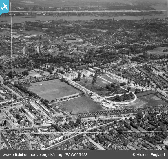
EAW005423 ENGLAND (1947). Prefabricated housing under construction around Rectory Field Crescent, Rectory Field and environs, Charlton, 1947. This image was marked by Aerofilms Ltd for photo editing.
© Copyright OpenStreetMap contributors and licensed by the OpenStreetMap Foundation. 2026. Cartography is licensed as CC BY-SA.
Nearby Images (21)
Details
| Title | [EAW005423] Prefabricated housing under construction around Rectory Field Crescent, Rectory Field and environs, Charlton, 1947. This image was marked by Aerofilms Ltd for photo editing. |
| Reference | EAW005423 |
| Date | May-1947 |
| Link | |
| Place name | CHARLTON |
| Parish | |
| District | |
| Country | ENGLAND |
| Easting / Northing | 541130, 177506 |
| Longitude / Latitude | 0.032529902816829, 51.478396787931 |
| National Grid Reference | TQ411775 |
Pins

gBr |
Monday 19th of October 2015 04:20:16 PM |


![[EAW005423] Prefabricated housing under construction around Rectory Field Crescent, Rectory Field and environs, Charlton, 1947. This image was marked by Aerofilms Ltd for photo editing.](http://britainfromabove.org.uk/sites/all/libraries/aerofilms-images/public/100x100/EAW/005/EAW005423.jpg)
![[EAW005427] Flats at Fairlawn, Charlton, 1947. This image was marked by Aerofilms Ltd for photo editing.](http://britainfromabove.org.uk/sites/all/libraries/aerofilms-images/public/100x100/EAW/005/EAW005427.jpg)
![[EAW005430] Flats at Fairlawn and prefabricated housing around Rectory Field Crescent, Charlton, 1947. This image was marked by Aerofilms Ltd for photo editing.](http://britainfromabove.org.uk/sites/all/libraries/aerofilms-images/public/100x100/EAW/005/EAW005430.jpg)
![[EAW005426] Rectory Field and prefabricated housing under construction around Rectory Field Crescent, Charlton, 1947. This image was marked by Aerofilms Ltd for photo editing.](http://britainfromabove.org.uk/sites/all/libraries/aerofilms-images/public/100x100/EAW/005/EAW005426.jpg)
![[EAW005428] Flats at Fairlawn and prefabricated housing under construction around Rectory Field Crescent, Charlton, 1947. This image was marked by Aerofilms Ltd for photo editing.](http://britainfromabove.org.uk/sites/all/libraries/aerofilms-images/public/100x100/EAW/005/EAW005428.jpg)
![[EAW005418] Prefabricated housing under construction around Rectory Field Crescent, Charlton, 1947](http://britainfromabove.org.uk/sites/all/libraries/aerofilms-images/public/100x100/EAW/005/EAW005418.jpg)
![[EAW005422] Prefabricated housing under construction around Rectory Field Crescent, Rectory Field and environs, Charlton, 1947. This image was marked by Aerofilms Ltd for photo editing.](http://britainfromabove.org.uk/sites/all/libraries/aerofilms-images/public/100x100/EAW/005/EAW005422.jpg)
![[EAW005420] Prefabricated housing under construction around Rectory Field Crescent, Rectory Field and environs, Charlton, 1947. This image was marked by Aerofilms Ltd for photo editing.](http://britainfromabove.org.uk/sites/all/libraries/aerofilms-images/public/100x100/EAW/005/EAW005420.jpg)
![[EAW005425] Prefabricated housing under construction around Rectory Field Crescent, Charlton, 1947. This image was marked by Aerofilms Ltd for photo editing.](http://britainfromabove.org.uk/sites/all/libraries/aerofilms-images/public/100x100/EAW/005/EAW005425.jpg)
![[EAW005429] Rectory Field and prefabricated housing under construction around Rectory Field Crescent, Charlton, 1947. This image was marked by Aerofilms Ltd for photo editing.](http://britainfromabove.org.uk/sites/all/libraries/aerofilms-images/public/100x100/EAW/005/EAW005429.jpg)
![[EAW005424] Prefabricated housing under construction around Rectory Field Crescent, Rectory Field and environs, Charlton, 1947. This image was marked by Aerofilms Ltd for photo editing.](http://britainfromabove.org.uk/sites/all/libraries/aerofilms-images/public/100x100/EAW/005/EAW005424.jpg)
![[EAW005419] Prefabricated housing under construction around Rectory Field Crescent, Rectory Field and environs, Charlton, 1947. This image was marked by Aerofilms Ltd for photo editing.](http://britainfromabove.org.uk/sites/all/libraries/aerofilms-images/public/100x100/EAW/005/EAW005419.jpg)
![[EAW042249] The Springfield Housing Estate, Charlton, 1952. This image was marked by Aerofilms Ltd for photo editing.](http://britainfromabove.org.uk/sites/all/libraries/aerofilms-images/public/100x100/EAW/042/EAW042249.jpg)
![[EAW042245] The Springfield Housing Estate, Charlton, 1952. This image was marked by Aerofilms Ltd for photo editing.](http://britainfromabove.org.uk/sites/all/libraries/aerofilms-images/public/100x100/EAW/042/EAW042245.jpg)
![[EAW042244] The Springfield Housing Estate, Charlton, 1952. This image was marked by Aerofilms Ltd for photo editing.](http://britainfromabove.org.uk/sites/all/libraries/aerofilms-images/public/100x100/EAW/042/EAW042244.jpg)
![[EAW042246] The Springfield Housing Estate, Charlton, 1952. This image was marked by Aerofilms Ltd for photo editing.](http://britainfromabove.org.uk/sites/all/libraries/aerofilms-images/public/100x100/EAW/042/EAW042246.jpg)
![[EAW042242] The Springfield Housing Estate, Charlton, 1952. This image was marked by Aerofilms Ltd for photo editing.](http://britainfromabove.org.uk/sites/all/libraries/aerofilms-images/public/100x100/EAW/042/EAW042242.jpg)
![[EAW042247] The Springfield Housing Estate, Charlton, 1952. This image was marked by Aerofilms Ltd for photo editing.](http://britainfromabove.org.uk/sites/all/libraries/aerofilms-images/public/100x100/EAW/042/EAW042247.jpg)
![[EAW042250] The Springfield Housing Estate, Charlton, 1952. This image was marked by Aerofilms Ltd for photo editing.](http://britainfromabove.org.uk/sites/all/libraries/aerofilms-images/public/100x100/EAW/042/EAW042250.jpg)
![[EAW042243] The Springfield Housing Estate, Charlton, 1952. This image was marked by Aerofilms Ltd for photo editing.](http://britainfromabove.org.uk/sites/all/libraries/aerofilms-images/public/100x100/EAW/042/EAW042243.jpg)
![[EAW042241] The Springfield Housing Estate, Charlton, 1952. This image was marked by Aerofilms Ltd for photo editing.](http://britainfromabove.org.uk/sites/all/libraries/aerofilms-images/public/100x100/EAW/042/EAW042241.jpg)