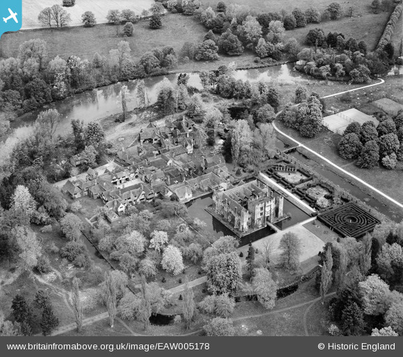
EAW005178 ENGLAND (1947). Hever Castle and the Tudor Gardens, Hever, 1947
© Copyright OpenStreetMap contributors and licensed by the OpenStreetMap Foundation. 2026. Cartography is licensed as CC BY-SA.
Nearby Images (7)
Details
| Title | [EAW005178] Hever Castle and the Tudor Gardens, Hever, 1947 |
| Reference | EAW005178 |
| Date | 9-May-1947 |
| Link | |
| Place name | HEVER |
| Parish | HEVER |
| District | |
| Country | ENGLAND |
| Easting / Northing | 547807, 145247 |
| Longitude / Latitude | 0.11523377080825, 51.186792829344 |
| National Grid Reference | TQ478452 |
Pins

Matt Aldred edob.mattaldred.com |
Friday 1st of January 2021 10:15:08 PM | |

totoro |
Wednesday 2nd of October 2013 07:52:44 PM | |

totoro |
Wednesday 2nd of October 2013 07:34:27 PM | |

totoro |
Wednesday 2nd of October 2013 07:16:57 PM |


![[EAW005178] Hever Castle and the Tudor Gardens, Hever, 1947](http://britainfromabove.org.uk/sites/all/libraries/aerofilms-images/public/100x100/EAW/005/EAW005178.jpg)
![[EAW005176] Hever Castle and the Tudor Gardens, Hever, 1947](http://britainfromabove.org.uk/sites/all/libraries/aerofilms-images/public/100x100/EAW/005/EAW005176.jpg)
![[EAW005174] Hever Castle and the Tudor Gardens, Hever, 1947](http://britainfromabove.org.uk/sites/all/libraries/aerofilms-images/public/100x100/EAW/005/EAW005174.jpg)
![[EAW005177] Hever Castle and the Tudor Gardens, Hever, 1947](http://britainfromabove.org.uk/sites/all/libraries/aerofilms-images/public/100x100/EAW/005/EAW005177.jpg)
![[EAW005175] Hever Castle and the Tudor Gardens, Hever, 1947](http://britainfromabove.org.uk/sites/all/libraries/aerofilms-images/public/100x100/EAW/005/EAW005175.jpg)
![[EAW005179] The Lake and Gardens at Hever Castle, Hever, 1947](http://britainfromabove.org.uk/sites/all/libraries/aerofilms-images/public/100x100/EAW/005/EAW005179.jpg)
![[EAW005180] The Lake and Gardens at Hever Castle, Hever, 1947](http://britainfromabove.org.uk/sites/all/libraries/aerofilms-images/public/100x100/EAW/005/EAW005180.jpg)