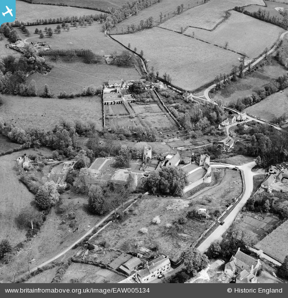
EAW005134 ENGLAND (1947). Farleigh Castle, Farleigh Hungerford, 1947
© Copyright OpenStreetMap contributors and licensed by the OpenStreetMap Foundation. 2025. Cartography is licensed as CC BY-SA.
Nearby Images (6)
Details
| Title | [EAW005134] Farleigh Castle, Farleigh Hungerford, 1947 |
| Reference | EAW005134 |
| Date | 7-September-1947 |
| Link | |
| Place name | FARLEIGH HUNGERFORD |
| Parish | NORTON ST. PHILIP |
| District | |
| Country | ENGLAND |
| Easting / Northing | 380162, 157701 |
| Longitude / Latitude | -2.2846901940091, 51.317566289985 |
| National Grid Reference | ST802577 |
Pins

Matt Aldred edob.mattaldred.com |
Monday 19th of July 2021 04:23:42 PM | |

James Chandler |
Friday 8th of November 2013 01:55:23 AM | |

totoro |
Sunday 6th of October 2013 09:28:34 PM | |

totoro |
Sunday 6th of October 2013 09:28:14 PM | |

totoro |
Sunday 6th of October 2013 09:19:00 PM | |

totoro |
Sunday 6th of October 2013 09:18:35 PM | |

totoro |
Sunday 6th of October 2013 09:18:11 PM | |

totoro |
Sunday 6th of October 2013 09:17:36 PM | |

totoro |
Sunday 6th of October 2013 09:16:55 PM | |

totoro |
Sunday 6th of October 2013 09:16:27 PM | |

totoro |
Sunday 6th of October 2013 09:15:54 PM | |

totoro |
Sunday 6th of October 2013 09:15:21 PM |


![[EAW005134] Farleigh Castle, Farleigh Hungerford, 1947](http://britainfromabove.org.uk/sites/all/libraries/aerofilms-images/public/100x100/EAW/005/EAW005134.jpg)
![[EAW005129] Farleigh Castle, Farleigh Hungerford, 1947. This image has been produced from a print.](http://britainfromabove.org.uk/sites/all/libraries/aerofilms-images/public/100x100/EAW/005/EAW005129.jpg)
![[EAW005130] Farleigh Castle, Farleigh Hungerford, 1947. This image has been produced from a print.](http://britainfromabove.org.uk/sites/all/libraries/aerofilms-images/public/100x100/EAW/005/EAW005130.jpg)
![[EAW005132] Farleigh Castle, Farleigh Hungerford, 1947. This image has been produced from a print.](http://britainfromabove.org.uk/sites/all/libraries/aerofilms-images/public/100x100/EAW/005/EAW005132.jpg)
![[EAW005133] Farleigh Castle, Farleigh Hungerford, 1947. This image has been produced from a print.](http://britainfromabove.org.uk/sites/all/libraries/aerofilms-images/public/100x100/EAW/005/EAW005133.jpg)
![[EAW005131] Farleigh Castle, Farleigh Hungerford, 1947](http://britainfromabove.org.uk/sites/all/libraries/aerofilms-images/public/100x100/EAW/005/EAW005131.jpg)