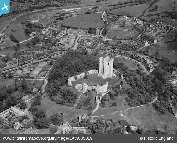
EAW005019 ENGLAND (1947). Conisbrough Castle, Conisbrough, 1947
© Copyright OpenStreetMap contributors and licensed by the OpenStreetMap Foundation. 2026. Cartography is licensed as CC BY-SA.
Nearby Images (6)
Details
| Title | [EAW005019] Conisbrough Castle, Conisbrough, 1947 |
| Reference | EAW005019 |
| Date | 7-May-1947 |
| Link | |
| Place name | CONISBROUGH |
| Parish | |
| District | |
| Country | ENGLAND |
| Easting / Northing | 451502, 398953 |
| Longitude / Latitude | -1.223779265739, 53.484519447973 |
| National Grid Reference | SK515990 |
Pins

totoro |
Monday 14th of October 2013 10:46:27 AM | |

totoro |
Monday 14th of October 2013 10:45:05 AM | |

totoro |
Monday 14th of October 2013 10:44:21 AM | |

totoro |
Monday 14th of October 2013 10:43:47 AM | |

totoro |
Monday 14th of October 2013 10:43:05 AM | |

totoro |
Monday 14th of October 2013 10:42:21 AM | |

totoro |
Monday 14th of October 2013 10:41:54 AM | |

totoro |
Monday 14th of October 2013 10:41:30 AM | |

totoro |
Monday 14th of October 2013 10:40:55 AM | |

totoro |
Monday 14th of October 2013 10:39:53 AM |


![[EAW005019] Conisbrough Castle, Conisbrough, 1947](http://britainfromabove.org.uk/sites/all/libraries/aerofilms-images/public/100x100/EAW/005/EAW005019.jpg)
![[EAW005016] Conisbrough Castle, Conisbrough, 1947](http://britainfromabove.org.uk/sites/all/libraries/aerofilms-images/public/100x100/EAW/005/EAW005016.jpg)
![[EAW005017] Conisbrough Castle, Conisbrough, 1947. This image has been produced from a print.](http://britainfromabove.org.uk/sites/all/libraries/aerofilms-images/public/100x100/EAW/005/EAW005017.jpg)
![[EAW005018] Conisbrough Castle, Conisbrough, 1947. This image has been produced from a print.](http://britainfromabove.org.uk/sites/all/libraries/aerofilms-images/public/100x100/EAW/005/EAW005018.jpg)
![[EAW005020] Conisbrough Castle, Conisbrough, 1947. This image has been produced from a print.](http://britainfromabove.org.uk/sites/all/libraries/aerofilms-images/public/100x100/EAW/005/EAW005020.jpg)
![[EPW014866] Conisbrough Castle, Conisbrough, 1926. This image has been produced from a copy-negative.](http://britainfromabove.org.uk/sites/all/libraries/aerofilms-images/public/100x100/EPW/014/EPW014866.jpg)