
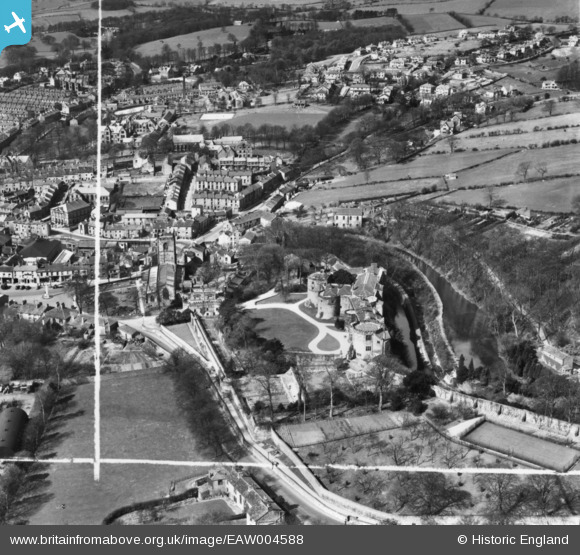
EAW004588 ENGLAND (1947). Skipton Castle and the town, Skipton, 1947. This image has been produced from a print marked by Aerofilms Ltd for photo editing.
© Copyright OpenStreetMap contributors and licensed by the OpenStreetMap Foundation. 2026. Cartography is licensed as CC BY-SA.
Nearby Images (15)
EAW004588

EAW016500
 and the town, Skipton, 1948. This image has been produced from a damaged negative.")
EAW016502
, Skipton, 1948. This image has been produced from a damaged negative.")
EAW016501
, Skipton, 1948. This image has been produced from a damaged negative.")
EAW016504

EAW004589

EAW004591

EAW016503

EAW013872

EAW013871

EAW004590

EAW016499

EAW013874

EAW013873

EPW024533

Details
| Title | [EAW004588] Skipton Castle and the town, Skipton, 1947. This image has been produced from a print marked by Aerofilms Ltd for photo editing. |
| Reference | EAW004588 |
| Date | 17-April-1947 |
| Link | |
| Place name | SKIPTON |
| Parish | SKIPTON |
| District | |
| Country | ENGLAND |
| Easting / Northing | 399046, 451982 |
| Longitude / Latitude | -2.0145426407311, 53.963723284393 |
| National Grid Reference | SD990520 |
Pins

Wag |
Sunday 12th of April 2020 10:19:45 AM | |
|
John W |
Monday 17th of April 2017 03:21:08 PM | |
|
John W |
Monday 17th of April 2017 03:20:36 PM | |
|
John W |
Monday 17th of April 2017 03:20:04 PM | |
|
John W |
Monday 17th of April 2017 03:16:01 PM | |
|
John W |
Monday 17th of April 2017 03:15:15 PM | |
|
John W |
Monday 17th of April 2017 03:14:30 PM |