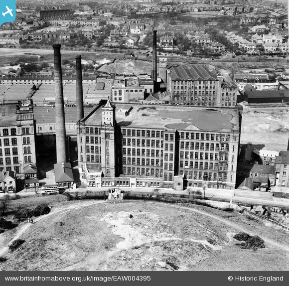
EAW004395 ENGLAND (1947). Park Road Cotton Mill, Dukinfield, 1947
© Copyright OpenStreetMap contributors and licensed by the OpenStreetMap Foundation. 2026. Cartography is licensed as CC BY-SA.
Nearby Images (16)
Details
| Title | [EAW004395] Park Road Cotton Mill, Dukinfield, 1947 |
| Reference | EAW004395 |
| Date | 13-April-1947 |
| Link | |
| Place name | DUKINFIELD |
| Parish | |
| District | |
| Country | ENGLAND |
| Easting / Northing | 394550, 398376 |
| Longitude / Latitude | -2.0821346297584, 53.481824839762 |
| National Grid Reference | SJ946984 |
Pins
Be the first to add a comment to this image!


![[EAW004395] Park Road Cotton Mill, Dukinfield, 1947](http://britainfromabove.org.uk/sites/all/libraries/aerofilms-images/public/100x100/EAW/004/EAW004395.jpg)
![[EAW030712] The Park Road Spinning Co Ltd Mill, Dukinfield, 1950. This image was marked by Aerofilms Ltd for photo editing.](http://britainfromabove.org.uk/sites/all/libraries/aerofilms-images/public/100x100/EAW/030/EAW030712.jpg)
![[EAW004398] Park Road Cotton Mill, Dukinfield, from the south-west, 1947. This image was marked by Aerofilms Ltd for photo editing.](http://britainfromabove.org.uk/sites/all/libraries/aerofilms-images/public/100x100/EAW/004/EAW004398.jpg)
![[EAW030718] The Park Road Spinning Co Ltd Mill, Dukinfield, 1950. This image was marked by Aerofilms Ltd for photo editing.](http://britainfromabove.org.uk/sites/all/libraries/aerofilms-images/public/100x100/EAW/030/EAW030718.jpg)
![[EAW030710] The Park Road Spinning Co Ltd Mill, Dukinfield, 1950. This image was marked by Aerofilms Ltd for photo editing.](http://britainfromabove.org.uk/sites/all/libraries/aerofilms-images/public/100x100/EAW/030/EAW030710.jpg)
![[EAW030717] The Park Road Spinning Co Ltd Mill and environs, Dukinfield, 1950. This image was marked by Aerofilms Ltd for photo editing.](http://britainfromabove.org.uk/sites/all/libraries/aerofilms-images/public/100x100/EAW/030/EAW030717.jpg)
![[EAW004393] Park Road Cotton Mill, Dukinfield, 1947](http://britainfromabove.org.uk/sites/all/libraries/aerofilms-images/public/100x100/EAW/004/EAW004393.jpg)
![[EAW030716] The Park Road Spinning Co Ltd Mill, Dukinfield, 1950. This image was marked by Aerofilms Ltd for photo editing.](http://britainfromabove.org.uk/sites/all/libraries/aerofilms-images/public/100x100/EAW/030/EAW030716.jpg)
![[EAW030715] The Park Road Spinning Co Ltd Mill, Dukinfield, 1950. This image was marked by Aerofilms Ltd for photo editing.](http://britainfromabove.org.uk/sites/all/libraries/aerofilms-images/public/100x100/EAW/030/EAW030715.jpg)
![[EAW030711] The Park Road Spinning Co Ltd Mill, Dukinfield, 1950. This image was marked by Aerofilms Ltd for photo editing.](http://britainfromabove.org.uk/sites/all/libraries/aerofilms-images/public/100x100/EAW/030/EAW030711.jpg)
![[EAW004394] Park Road Cotton Mill, Dukinfield, 1947. This image was marked by Aerofilms Ltd for photo editing.](http://britainfromabove.org.uk/sites/all/libraries/aerofilms-images/public/100x100/EAW/004/EAW004394.jpg)
![[EAW030709] The Park Road Spinning Co Ltd Mill, Dukinfield, 1950. This image was marked by Aerofilms Ltd for photo editing.](http://britainfromabove.org.uk/sites/all/libraries/aerofilms-images/public/100x100/EAW/030/EAW030709.jpg)
![[EAW030714] The Park Road Spinning Co Ltd Mill, Dukinfield, 1950. This image was marked by Aerofilms Ltd for photo editing.](http://britainfromabove.org.uk/sites/all/libraries/aerofilms-images/public/100x100/EAW/030/EAW030714.jpg)
![[EAW004397] Park Road Cotton Mill, Dukinfield, 1947. This image was marked by Aerofilms Ltd for photo editing.](http://britainfromabove.org.uk/sites/all/libraries/aerofilms-images/public/100x100/EAW/004/EAW004397.jpg)
![[EAW030713] The Park Road Spinning Co Ltd Mill and the cemetery, Dukinfield, 1950. This image was marked by Aerofilms Ltd for photo editing.](http://britainfromabove.org.uk/sites/all/libraries/aerofilms-images/public/100x100/EAW/030/EAW030713.jpg)
![[EAW004396] Park Road Cotton Mill, Dukinfield, 1947. This image was marked by Aerofilms Ltd for photo editing.](http://britainfromabove.org.uk/sites/all/libraries/aerofilms-images/public/100x100/EAW/004/EAW004396.jpg)