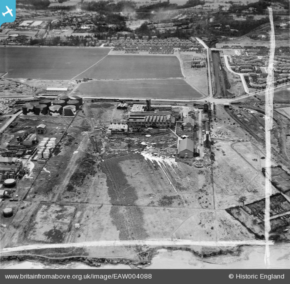
EAW004088 ENGLAND (1947). The Mersey Chemical Works, Bromborough, 1947. This image was marked by Aerofilms Ltd for photo editing.
© Copyright OpenStreetMap contributors and licensed by the OpenStreetMap Foundation. 2026. Cartography is licensed as CC BY-SA.
Nearby Images (45)
Details
| Title | [EAW004088] The Mersey Chemical Works, Bromborough, 1947. This image was marked by Aerofilms Ltd for photo editing. |
| Reference | EAW004088 |
| Date | 25-March-1947 |
| Link | |
| Place name | BROMBOROUGH |
| Parish | |
| District | |
| Country | ENGLAND |
| Easting / Northing | 335411, 383355 |
| Longitude / Latitude | -2.9702392682075, 53.342876366032 |
| National Grid Reference | SJ354834 |
Pins

Matt Aldred edob.mattaldred.com |
Monday 8th of March 2021 08:35:50 PM | |

redmist |
Sunday 13th of October 2019 11:55:47 AM | |

redmist |
Sunday 13th of October 2019 11:36:41 AM | |

redmist |
Sunday 13th of October 2019 11:34:44 AM | |

Sparky |
Thursday 28th of September 2017 09:52:47 PM | |

dogdirt |
Monday 4th of November 2013 08:41:12 PM | |

dogdirt |
Monday 4th of November 2013 08:29:28 PM | |
My family lived there (211 spital) from approx 82-89 - are you the mullins family? |

Allyslife |
Friday 25th of November 2016 01:15:23 PM |

dogdirt |
Monday 4th of November 2013 08:26:19 PM |


![[EAW004088] The Mersey Chemical Works, Bromborough, 1947. This image was marked by Aerofilms Ltd for photo editing.](http://britainfromabove.org.uk/sites/all/libraries/aerofilms-images/public/100x100/EAW/004/EAW004088.jpg)
![[EPW061646] Brotherton & Co Port Rainbow Chemical Works and the Hardening Plant Oil Refinery, Bromborough, 1939](http://britainfromabove.org.uk/sites/all/libraries/aerofilms-images/public/100x100/EPW/061/EPW061646.jpg)
![[EAW004089] The Mersey Chemical Works, Bromborough, 1947. This image was marked by Aerofilms Ltd for photo editing.](http://britainfromabove.org.uk/sites/all/libraries/aerofilms-images/public/100x100/EAW/004/EAW004089.jpg)
![[EAW008554] Brotherton & Co Mersey Chemical Works, Bromborough, 1947](http://britainfromabove.org.uk/sites/all/libraries/aerofilms-images/public/100x100/EAW/008/EAW008554.jpg)
![[EAW008553] Brotherton & Co Mersey Chemical Works, Bromborough, 1947](http://britainfromabove.org.uk/sites/all/libraries/aerofilms-images/public/100x100/EAW/008/EAW008553.jpg)
![[EPW061647] Brotherton & Co Port Rainbow Chemical Works, Bromborough, 1939](http://britainfromabove.org.uk/sites/all/libraries/aerofilms-images/public/100x100/EPW/061/EPW061647.jpg)
![[EAW046248] Brotherton and Co Mersey Chemical Works, Bromborough, 1952. This image was marked by Aerofilms Ltd for photo editing.](http://britainfromabove.org.uk/sites/all/libraries/aerofilms-images/public/100x100/EAW/046/EAW046248.jpg)
![[EPW061645] Brotherton & Co Port Rainbow Chemical Works, Bromborough, 1939](http://britainfromabove.org.uk/sites/all/libraries/aerofilms-images/public/100x100/EPW/061/EPW061645.jpg)
![[EAW046246] Brotherton and Co Mersey Chemical Works, Bromborough, 1952. This image was marked by Aerofilms Ltd for photo editing.](http://britainfromabove.org.uk/sites/all/libraries/aerofilms-images/public/100x100/EAW/046/EAW046246.jpg)
![[EPW025160] Brotherton and Co Mersey Chemical Works, Bromborough, 1928](http://britainfromabove.org.uk/sites/all/libraries/aerofilms-images/public/100x100/EPW/025/EPW025160.jpg)
![[EPW025167] Brotherton and Co Mersey Chemical Works and the Hardening Plant Oil Refinery, Bromborough, 1928](http://britainfromabove.org.uk/sites/all/libraries/aerofilms-images/public/100x100/EPW/025/EPW025167.jpg)
![[EAW008556] Brotherton & Co Mersey Chemical Works, Bromborough, 1947](http://britainfromabove.org.uk/sites/all/libraries/aerofilms-images/public/100x100/EAW/008/EAW008556.jpg)
![[EPW025170] Brotherton and Co Mersey Chemical Works, Bromborough, 1928](http://britainfromabove.org.uk/sites/all/libraries/aerofilms-images/public/100x100/EPW/025/EPW025170.jpg)
![[EAW046241] Brotherton and Co Mersey Chemical Works and environs, Bromborough, 1952. This image was marked by Aerofilms Ltd for photo editing.](http://britainfromabove.org.uk/sites/all/libraries/aerofilms-images/public/100x100/EAW/046/EAW046241.jpg)
![[EPW025163] Brotherton and Co Mersey Chemical Works, Bromborough, 1928](http://britainfromabove.org.uk/sites/all/libraries/aerofilms-images/public/100x100/EPW/025/EPW025163.jpg)
![[EPW025166] Brotherton and Co Mersey Chemical Works, Bromborough, 1928](http://britainfromabove.org.uk/sites/all/libraries/aerofilms-images/public/100x100/EPW/025/EPW025166.jpg)
![[EAW046240] Brotherton and Co Mersey Chemical Works, Bromborough, 1952. This image was marked by Aerofilms Ltd for photo editing.](http://britainfromabove.org.uk/sites/all/libraries/aerofilms-images/public/100x100/EAW/046/EAW046240.jpg)
![[EPW061648] Brotherton & Co Port Rainbow Chemical Works, Bromborough, 1939](http://britainfromabove.org.uk/sites/all/libraries/aerofilms-images/public/100x100/EPW/061/EPW061648.jpg)
![[EPW061651] Brotherton & Co Port Rainbow Chemical Works, Bromborough, 1939](http://britainfromabove.org.uk/sites/all/libraries/aerofilms-images/public/100x100/EPW/061/EPW061651.jpg)
![[EPW025165] Brotherton and Co Mersey Chemical Works, Bromborough, 1928](http://britainfromabove.org.uk/sites/all/libraries/aerofilms-images/public/100x100/EPW/025/EPW025165.jpg)
![[EPW061650] Brotherton & Co Port Rainbow Chemical Works, Bromborough, 1939](http://britainfromabove.org.uk/sites/all/libraries/aerofilms-images/public/100x100/EPW/061/EPW061650.jpg)
![[EAW046245] Brotherton and Co Mersey Chemical Works, Bromborough, 1952. This image was marked by Aerofilms Ltd for photo editing.](http://britainfromabove.org.uk/sites/all/libraries/aerofilms-images/public/100x100/EAW/046/EAW046245.jpg)
![[EPW025169] Brotherton and Co Mersey Chemical Works, Bromborough, 1928](http://britainfromabove.org.uk/sites/all/libraries/aerofilms-images/public/100x100/EPW/025/EPW025169.jpg)
![[EPW025164] Brotherton and Co Mersey Chemical Works, Bromborough, 1928](http://britainfromabove.org.uk/sites/all/libraries/aerofilms-images/public/100x100/EPW/025/EPW025164.jpg)
![[EPW061649] Brotherton & Co Port Rainbow Chemical Works, Bromborough, 1939](http://britainfromabove.org.uk/sites/all/libraries/aerofilms-images/public/100x100/EPW/061/EPW061649.jpg)
![[EAW046243] Brotherton and Co Mersey Chemical Works, Bromborough, 1952. This image was marked by Aerofilms Ltd for photo editing.](http://britainfromabove.org.uk/sites/all/libraries/aerofilms-images/public/100x100/EAW/046/EAW046243.jpg)
![[EPW025171] Brotherton and Co Mersey Chemical Works, Bromborough, 1928](http://britainfromabove.org.uk/sites/all/libraries/aerofilms-images/public/100x100/EPW/025/EPW025171.jpg)
![[EAW008555] Brotherton & Co Mersey Chemical Works, Bromborough, 1947. This image was marked by Aerofilms Ltd for photo editing.](http://britainfromabove.org.uk/sites/all/libraries/aerofilms-images/public/100x100/EAW/008/EAW008555.jpg)
![[EAW046247] Brotherton and Co Mersey Chemical Works, Bromborough, 1952. This image was marked by Aerofilms Ltd for photo editing.](http://britainfromabove.org.uk/sites/all/libraries/aerofilms-images/public/100x100/EAW/046/EAW046247.jpg)
![[EPW025172] Brotherton and Co Mersey Chemical Works, Bromborough, 1928](http://britainfromabove.org.uk/sites/all/libraries/aerofilms-images/public/100x100/EPW/025/EPW025172.jpg)
![[EAW004095] The Mersey Chemical Works and the River Mersey, Bromborough, 1947. This image was marked by Aerofilms Ltd for photo editing.](http://britainfromabove.org.uk/sites/all/libraries/aerofilms-images/public/100x100/EAW/004/EAW004095.jpg)
![[EPW025173] Brotherton and Co Mersey Chemical Works, Bromborough, 1928](http://britainfromabove.org.uk/sites/all/libraries/aerofilms-images/public/100x100/EPW/025/EPW025173.jpg)
![[EPW025161] Brotherton and Co Mersey Chemical Works, Bromborough, 1928](http://britainfromabove.org.uk/sites/all/libraries/aerofilms-images/public/100x100/EPW/025/EPW025161.jpg)
![[EPW025162] Brotherton and Co Mersey Chemical Works, Bromborough, 1928](http://britainfromabove.org.uk/sites/all/libraries/aerofilms-images/public/100x100/EPW/025/EPW025162.jpg)
![[EPW025168] Brotherton and Co Mersey Chemical Works, Bromborough, 1928](http://britainfromabove.org.uk/sites/all/libraries/aerofilms-images/public/100x100/EPW/025/EPW025168.jpg)
![[EAW008558] Brotherton & Co Mersey Chemical Works and the River Mersey, Bromborough, from the west, 1947. This image was marked by Aerofilms Ltd for photo editing.](http://britainfromabove.org.uk/sites/all/libraries/aerofilms-images/public/100x100/EAW/008/EAW008558.jpg)
![[EAW046244] Brotherton and Co Mersey Chemical Works, Bromborough, 1952. This image was marked by Aerofilms Ltd for photo editing.](http://britainfromabove.org.uk/sites/all/libraries/aerofilms-images/public/100x100/EAW/046/EAW046244.jpg)
![[EAW008557] Brotherton & Co Mersey Chemical Works and the River Mersey, Bromborough, from the west, 1947. This image was marked by Aerofilms Ltd for photo editing.](http://britainfromabove.org.uk/sites/all/libraries/aerofilms-images/public/100x100/EAW/008/EAW008557.jpg)
![[EAW046249] Brotherton and Co Mersey Chemical Works and environs, Bromborough, 1952. This image was marked by Aerofilms Ltd for photo editing.](http://britainfromabove.org.uk/sites/all/libraries/aerofilms-images/public/100x100/EAW/046/EAW046249.jpg)
![[EAW008552] Brotherton & Co Mersey Chemical Works and the River Mersey, Bromborough, from the west, 1947. This image was marked by Aerofilms Ltd for photo editing.](http://britainfromabove.org.uk/sites/all/libraries/aerofilms-images/public/100x100/EAW/008/EAW008552.jpg)
![[EAW004094] The Mersey Chemical Works and the Hardening Plant (Oil Refinery) and environs, Bromborough, from the north-west, 1947. This image was marked by Aerofilms Ltd for photo editing.](http://britainfromabove.org.uk/sites/all/libraries/aerofilms-images/public/100x100/EAW/004/EAW004094.jpg)
![[EAW004093] Bromborough Pool, the Mersey Chemical Works and the Hardening Plant (Oil Refinery), Bromborough, from the south, 1947. This image was marked by Aerofilms Ltd for photo editing.](http://britainfromabove.org.uk/sites/all/libraries/aerofilms-images/public/100x100/EAW/004/EAW004093.jpg)
![[EAW046242] Brotherton and Co Mersey Chemical Works, Bromborough, 1952. This image was marked by Aerofilms Ltd for photo editing.](http://britainfromabove.org.uk/sites/all/libraries/aerofilms-images/public/100x100/EAW/046/EAW046242.jpg)
![[EAW004091] The Mersey Chemical Works and the Hardening Plant (Oil Refinery) and environs, Bromborough, 1947. This image was marked by Aerofilms Ltd for photo editing.](http://britainfromabove.org.uk/sites/all/libraries/aerofilms-images/public/100x100/EAW/004/EAW004091.jpg)
![[EAW004090] The Mersey Chemical Works and the Hardening Plant (Oil Refinery) and environs, Bromborough, 1947. This image was marked by Aerofilms Ltd for photo editing.](http://britainfromabove.org.uk/sites/all/libraries/aerofilms-images/public/100x100/EAW/004/EAW004090.jpg)