
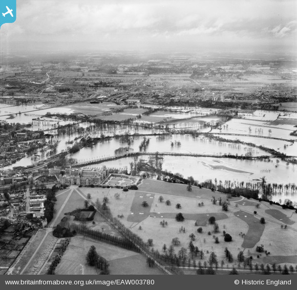
EAW003780 ENGLAND (1947). Flooding between Windsor and Datchet centred upon Windsor Castle, Windsor, from the south, 1947
© Copyright OpenStreetMap contributors and licensed by the OpenStreetMap Foundation. 2026. Cartography is licensed as CC BY-SA.
Nearby Images (6)
EAW003780

EAW003706

EPW022600

EPW000034

EAW006324

EAW006323

Details
| Title | [EAW003780] Flooding between Windsor and Datchet centred upon Windsor Castle, Windsor, from the south, 1947 |
| Reference | EAW003780 |
| Date | 19-March-1947 |
| Link | |
| Place name | WINDSOR |
| Parish | |
| District | |
| Country | ENGLAND |
| Easting / Northing | 497451, 176948 |
| Longitude / Latitude | -0.5964330581944, 51.482594900405 |
| National Grid Reference | SU975769 |
Pins

Mike Holder |
Saturday 3rd of February 2018 05:21:43 PM | |
|
Mike Holder |
Saturday 3rd of February 2018 05:20:28 PM | |
|
Mike Holder |
Saturday 3rd of February 2018 05:19:30 PM | |
|
Mike Holder |
Saturday 3rd of February 2018 05:16:40 PM | |
|
Mike Holder |
Saturday 3rd of February 2018 05:15:08 PM | |
|
Mike Holder |
Saturday 3rd of February 2018 05:12:46 PM | |
|
Mike Holder |
Saturday 3rd of February 2018 05:12:23 PM | |
|
Mike Holder |
Saturday 3rd of February 2018 05:11:15 PM | |

Class31 |
Friday 13th of September 2013 11:40:37 PM | |
|
Class31 |
Friday 13th of September 2013 11:34:27 PM | |
|
Class31 |
Friday 13th of September 2013 11:33:25 PM |