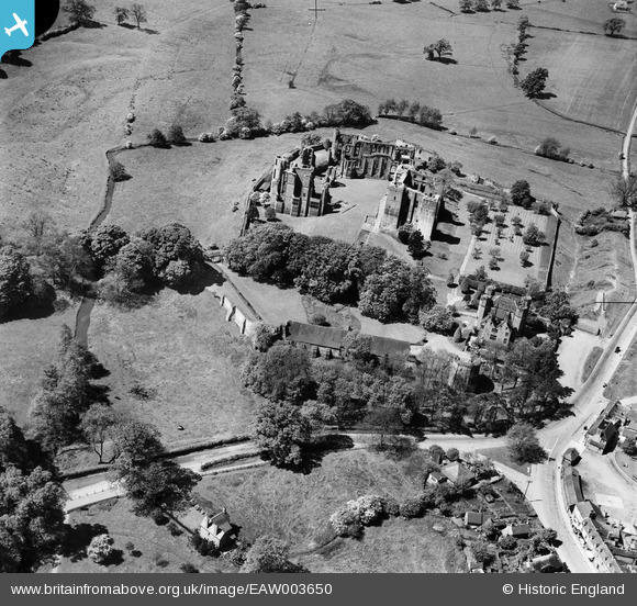
EAW003650 ENGLAND (1947). Kenilworth Castle, Kenilworth, 1947
© Copyright OpenStreetMap contributors and licensed by the OpenStreetMap Foundation. 2026. Cartography is licensed as CC BY-SA.
Nearby Images (28)
Details
| Title | [EAW003650] Kenilworth Castle, Kenilworth, 1947 |
| Reference | EAW003650 |
| Date | March-1947 |
| Link | |
| Place name | KENILWORTH |
| Parish | KENILWORTH |
| District | |
| Country | ENGLAND |
| Easting / Northing | 427924, 272251 |
| Longitude / Latitude | -1.5900246767533, 52.347234325902 |
| National Grid Reference | SP279723 |
Pins

Matt Aldred edob.mattaldred.com |
Saturday 14th of February 2026 10:45:07 PM |


![[EAW003650] Kenilworth Castle, Kenilworth, 1947](http://britainfromabove.org.uk/sites/all/libraries/aerofilms-images/public/100x100/EAW/003/EAW003650.jpg)
![[EAW006692] Kenilworth Castle, Kenilworth, 1947. This image has been produced from a print marked by Aerofilms Ltd for photo editing.](http://britainfromabove.org.uk/sites/all/libraries/aerofilms-images/public/100x100/EAW/006/EAW006692.jpg)
![[EAW003652] Kenilworth Castle, Kenilworth, 1947](http://britainfromabove.org.uk/sites/all/libraries/aerofilms-images/public/100x100/EAW/003/EAW003652.jpg)
![[EAW025676] Kenilworth Castle and the town, Kenilworth, from the south, 1949. This image has been produced from a print.](http://britainfromabove.org.uk/sites/all/libraries/aerofilms-images/public/100x100/EAW/025/EAW025676.jpg)
![[EAW006688] Kenilworth Castle, Kenilworth, 1947. This image has been produced from a print marked by Aerofilms Ltd for photo editing.](http://britainfromabove.org.uk/sites/all/libraries/aerofilms-images/public/100x100/EAW/006/EAW006688.jpg)
![[EAW007530] Kenilworth Castle, Kenilworth, 1947](http://britainfromabove.org.uk/sites/all/libraries/aerofilms-images/public/100x100/EAW/007/EAW007530.jpg)
![[EAW007522] Kenilworth Castle, Kenilworth, 1947](http://britainfromabove.org.uk/sites/all/libraries/aerofilms-images/public/100x100/EAW/007/EAW007522.jpg)
![[EAW007525] Kenilworth Castle, Kenilworth, 1947](http://britainfromabove.org.uk/sites/all/libraries/aerofilms-images/public/100x100/EAW/007/EAW007525.jpg)
![[EAW048850] Kenilworth Castle and the town, Kenilworth, from the west, 1953](http://britainfromabove.org.uk/sites/all/libraries/aerofilms-images/public/100x100/EAW/048/EAW048850.jpg)
![[EAW007523] Kenilworth Castle, Kenilworth, 1947](http://britainfromabove.org.uk/sites/all/libraries/aerofilms-images/public/100x100/EAW/007/EAW007523.jpg)
![[EAW007529] Kenilworth Castle, Kenilworth, 1947](http://britainfromabove.org.uk/sites/all/libraries/aerofilms-images/public/100x100/EAW/007/EAW007529.jpg)
![[EAW007528] Kenilworth Castle, Kenilworth, 1947](http://britainfromabove.org.uk/sites/all/libraries/aerofilms-images/public/100x100/EAW/007/EAW007528.jpg)
![[EAW006689] Kenilworth Castle, Kenilworth, 1947. This image has been produced from a print marked by Aerofilms Ltd for photo editing.](http://britainfromabove.org.uk/sites/all/libraries/aerofilms-images/public/100x100/EAW/006/EAW006689.jpg)
![[EAW006690] Kenilworth Castle, Kenilworth, 1947. This image was marked by Aerofilms Ltd for photo editing.](http://britainfromabove.org.uk/sites/all/libraries/aerofilms-images/public/100x100/EAW/006/EAW006690.jpg)
![[EAW007526] Kenilworth Castle, Kenilworth, 1947](http://britainfromabove.org.uk/sites/all/libraries/aerofilms-images/public/100x100/EAW/007/EAW007526.jpg)
![[EPW015073] Kenilworth Castle, Kenilworth, 1926. This image has been produced from a copy-negative.](http://britainfromabove.org.uk/sites/all/libraries/aerofilms-images/public/100x100/EPW/015/EPW015073.jpg)
![[EAW001826] Kenilworth Castle, Kenilworth, 1946](http://britainfromabove.org.uk/sites/all/libraries/aerofilms-images/public/100x100/EAW/001/EAW001826.jpg)
![[EAW001827] Kenilworth Castle, Kenilworth, 1946](http://britainfromabove.org.uk/sites/all/libraries/aerofilms-images/public/100x100/EAW/001/EAW001827.jpg)
![[EAW006693] Kenilworth Castle, Kenilworth, 1947. This image has been produced from a print marked by Aerofilms Ltd for photo editing.](http://britainfromabove.org.uk/sites/all/libraries/aerofilms-images/public/100x100/EAW/006/EAW006693.jpg)
![[EAW007524] Kenilworth Castle, Kenilworth, 1947](http://britainfromabove.org.uk/sites/all/libraries/aerofilms-images/public/100x100/EAW/007/EAW007524.jpg)
![[EPW015074] Kenilworth Castle, Kenilworth, 1926. This image has been produced from a copy-negative.](http://britainfromabove.org.uk/sites/all/libraries/aerofilms-images/public/100x100/EPW/015/EPW015074.jpg)
![[EAW003651] Kenilworth Castle, Kenilworth, 1947](http://britainfromabove.org.uk/sites/all/libraries/aerofilms-images/public/100x100/EAW/003/EAW003651.jpg)
![[EAW048848] Kenilworth Castle, Kenilworth, 1953](http://britainfromabove.org.uk/sites/all/libraries/aerofilms-images/public/100x100/EAW/048/EAW048848.jpg)
![[EAW007527] Kenilworth Castle, Kenilworth, 1947](http://britainfromabove.org.uk/sites/all/libraries/aerofilms-images/public/100x100/EAW/007/EAW007527.jpg)
![[EAW048847] Kenilworth Castle, Kenilworth, 1953](http://britainfromabove.org.uk/sites/all/libraries/aerofilms-images/public/100x100/EAW/048/EAW048847.jpg)
![[EPW001183] Kenilworth Castle, Kenilworth, 1920](http://britainfromabove.org.uk/sites/all/libraries/aerofilms-images/public/100x100/EPW/001/EPW001183.jpg)
![[EAW006691] Kenilworth Castle, Kenilworth, 1947. This image was marked by Aerofilms Ltd for photo editing.](http://britainfromabove.org.uk/sites/all/libraries/aerofilms-images/public/100x100/EAW/006/EAW006691.jpg)
![[EAW025679] Kenilworth Castle and environs, Kenilworth, from the south-west, 1949. This image has been produced from a print.](http://britainfromabove.org.uk/sites/all/libraries/aerofilms-images/public/100x100/EAW/025/EAW025679.jpg)