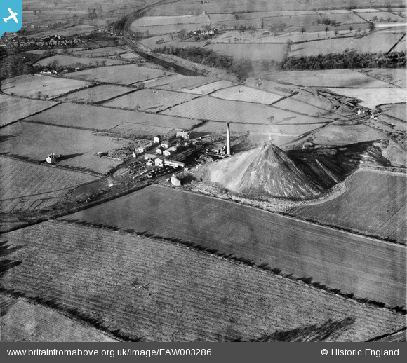
EAW003286 ENGLAND (1946). Cotes Park Colliery, Cotes Park, 1946
© Copyright OpenStreetMap contributors and licensed by the OpenStreetMap Foundation. 2026. Cartography is licensed as CC BY-SA.
Nearby Images (14)
Details
| Title | [EAW003286] Cotes Park Colliery, Cotes Park, 1946 |
| Reference | EAW003286 |
| Date | 4-November-1946 |
| Link | |
| Place name | COTES PARK |
| Parish | SOMERCOTES |
| District | |
| Country | ENGLAND |
| Easting / Northing | 442648, 354922 |
| Longitude / Latitude | -1.3631268336362, 53.08950714748 |
| National Grid Reference | SK426549 |
Pins

dd1000 |
Wednesday 17th of July 2019 07:56:15 PM | |

dd1000 |
Wednesday 17th of July 2019 07:55:10 PM | |

dd1000 |
Wednesday 17th of July 2019 07:54:48 PM | |

dd1000 |
Wednesday 17th of July 2019 03:56:01 PM | |

dd1000 |
Wednesday 17th of July 2019 03:55:06 PM | |

dd1000 |
Wednesday 17th of July 2019 03:54:06 PM |


![[EAW003286] Cotes Park Colliery, Cotes Park, 1946](http://britainfromabove.org.uk/sites/all/libraries/aerofilms-images/public/100x100/EAW/003/EAW003286.jpg)
![[EAW002813] The Cotes Park Colliery, Cotes Park, 1946](http://britainfromabove.org.uk/sites/all/libraries/aerofilms-images/public/100x100/EAW/002/EAW002813.jpg)
![[EAW002814] The Cotes Park Colliery, Cotes Park, from the south-west, 1946](http://britainfromabove.org.uk/sites/all/libraries/aerofilms-images/public/100x100/EAW/002/EAW002814.jpg)
![[EAW003277] Cotes Park Colliery, Cotes Park, from the south-west, 1946](http://britainfromabove.org.uk/sites/all/libraries/aerofilms-images/public/100x100/EAW/003/EAW003277.jpg)
![[EAW003276] Cotes Park Colliery, Cotes Park, from the south-west, 1946](http://britainfromabove.org.uk/sites/all/libraries/aerofilms-images/public/100x100/EAW/003/EAW003276.jpg)
![[EAW003282] Cotes Park Colliery, Cotes Park, 1946](http://britainfromabove.org.uk/sites/all/libraries/aerofilms-images/public/100x100/EAW/003/EAW003282.jpg)
![[EAW003278] Cotes Park Colliery, Cotes Park, 1946](http://britainfromabove.org.uk/sites/all/libraries/aerofilms-images/public/100x100/EAW/003/EAW003278.jpg)
![[EAW003280] Cotes Park Colliery, Cotes Park, from the south-west, 1946](http://britainfromabove.org.uk/sites/all/libraries/aerofilms-images/public/100x100/EAW/003/EAW003280.jpg)
![[EAW003285] Cotes Park Colliery, Cotes Park, 1946](http://britainfromabove.org.uk/sites/all/libraries/aerofilms-images/public/100x100/EAW/003/EAW003285.jpg)
![[EAW002812] The Cotes Park Colliery, Cotes Park, from the north-west, 1946](http://britainfromabove.org.uk/sites/all/libraries/aerofilms-images/public/100x100/EAW/002/EAW002812.jpg)
![[EAW003281] Cotes Park Colliery, Cotes Park, from the south, 1946](http://britainfromabove.org.uk/sites/all/libraries/aerofilms-images/public/100x100/EAW/003/EAW003281.jpg)
![[EAW003284] Cotes Park Colliery, Cotes Park, 1946](http://britainfromabove.org.uk/sites/all/libraries/aerofilms-images/public/100x100/EAW/003/EAW003284.jpg)
![[EAW003283] Cotes Park Colliery, Cotes Park, 1946](http://britainfromabove.org.uk/sites/all/libraries/aerofilms-images/public/100x100/EAW/003/EAW003283.jpg)
![[EAW003279] Cotes Park Colliery, Cotes Park, from the south-west, 1946](http://britainfromabove.org.uk/sites/all/libraries/aerofilms-images/public/100x100/EAW/003/EAW003279.jpg)