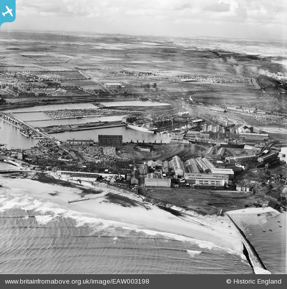
EAW003198 ENGLAND (1946). The Hartlepool Engine Works, Central Dock and the surrounding area, Hartlepool, from the east, 1946
© Copyright OpenStreetMap contributors and licensed by the OpenStreetMap Foundation. 2026. Cartography is licensed as CC BY-SA.
Nearby Images (16)
Details
| Title | [EAW003198] The Hartlepool Engine Works, Central Dock and the surrounding area, Hartlepool, from the east, 1946 |
| Reference | EAW003198 |
| Date | 23-October-1946 |
| Link | |
| Place name | HARTLEPOOL |
| Parish | |
| District | |
| Country | ENGLAND |
| Easting / Northing | 452175, 533476 |
| Longitude / Latitude | -1.1904361084682, 54.693506228614 |
| National Grid Reference | NZ522335 |
Pins

redmist |
Friday 30th of September 2022 02:37:45 PM | |

redmist |
Tuesday 22nd of September 2020 10:59:10 PM | |

redmist |
Tuesday 22nd of September 2020 10:58:47 PM | |

redmist |
Tuesday 22nd of September 2020 10:58:24 PM | |

redmist |
Sunday 27th of October 2019 12:34:29 AM | |

Glenn Harvey-Noble |
Monday 13th of January 2014 12:57:21 PM |


![[EAW003198] The Hartlepool Engine Works, Central Dock and the surrounding area, Hartlepool, from the east, 1946](http://britainfromabove.org.uk/sites/all/libraries/aerofilms-images/public/100x100/EAW/003/EAW003198.jpg)
![[EAW003195] The Hartlepool Engine Works, Central Dock and the surrounding area, Hartlepool, from the east, 1946](http://britainfromabove.org.uk/sites/all/libraries/aerofilms-images/public/100x100/EAW/003/EAW003195.jpg)
![[EAW003204] The Hartlepool Engine Works, Central Dock and the surrounding area, Hartlepool, from the east, 1946](http://britainfromabove.org.uk/sites/all/libraries/aerofilms-images/public/100x100/EAW/003/EAW003204.jpg)
![[EAW003194] The Hartlepool Engine Works, Central Dock and the surrounding area, Hartlepool, from the east, 1946](http://britainfromabove.org.uk/sites/all/libraries/aerofilms-images/public/100x100/EAW/003/EAW003194.jpg)
![[EAW003188] The Hartlepool Engine Works and the surrounding coastal area, Hartlepool, from the south-east, 1946](http://britainfromabove.org.uk/sites/all/libraries/aerofilms-images/public/100x100/EAW/003/EAW003188.jpg)
![[EAW003197] The Hartlepool Engine Works and Hartlepool Bay, Hartlepool, 1946](http://britainfromabove.org.uk/sites/all/libraries/aerofilms-images/public/100x100/EAW/003/EAW003197.jpg)
![[EAW003201] The Hartlepool Engine Works and the surrounding docks, Hartlepool, from the east, 1946](http://britainfromabove.org.uk/sites/all/libraries/aerofilms-images/public/100x100/EAW/003/EAW003201.jpg)
![[EPW054631] The Richardsons, Westgarth and Co Hartlepool Engine Works, Hartlepool, 1937. This image has been produced from a print.](http://britainfromabove.org.uk/sites/all/libraries/aerofilms-images/public/100x100/EPW/054/EPW054631.jpg)
![[EPW054577] Richardsons, Westgarth and Co Hartlepool Engine Works, Hartlepool, 1937](http://britainfromabove.org.uk/sites/all/libraries/aerofilms-images/public/100x100/EPW/054/EPW054577.jpg)
![[EAW003200] The Hartlepool Engine Works and the Old Harbour, Hartlepool, 1946](http://britainfromabove.org.uk/sites/all/libraries/aerofilms-images/public/100x100/EAW/003/EAW003200.jpg)
![[EPW054630] The Richardsons, Westgarth and Co Hartlepool Engine Works alongside Old Harbour and North Basin, Hartlepool, 1937. This image has been produced from a print.](http://britainfromabove.org.uk/sites/all/libraries/aerofilms-images/public/100x100/EPW/054/EPW054630.jpg)
![[EAW003199] The Hartlepool Engine Works and the Old Harbour, Hartlepool, 1946](http://britainfromabove.org.uk/sites/all/libraries/aerofilms-images/public/100x100/EAW/003/EAW003199.jpg)
![[EPW054636] The Richardsons, Westgarth and Co Hartlepool Engine Works alongside Old Harbour and Central Dock, Hartlepool, 1937. This image has been produced from a print.](http://britainfromabove.org.uk/sites/all/libraries/aerofilms-images/public/100x100/EPW/054/EPW054636.jpg)
![[EAW003187] The Old Harbour, the Hartlepool Engine Works and Hartlepool Bay, Hartlepool, 1946](http://britainfromabove.org.uk/sites/all/libraries/aerofilms-images/public/100x100/EAW/003/EAW003187.jpg)
![[EAW003193] The Hartlepool Engine Works, Jackson Dock and a smog covered town centre, Hartlepool, 1946](http://britainfromabove.org.uk/sites/all/libraries/aerofilms-images/public/100x100/EAW/003/EAW003193.jpg)
![[EAW003190] The Hartlepool Engine Works and the surrounding harbour, Hartlepool, 1946](http://britainfromabove.org.uk/sites/all/libraries/aerofilms-images/public/100x100/EAW/003/EAW003190.jpg)