
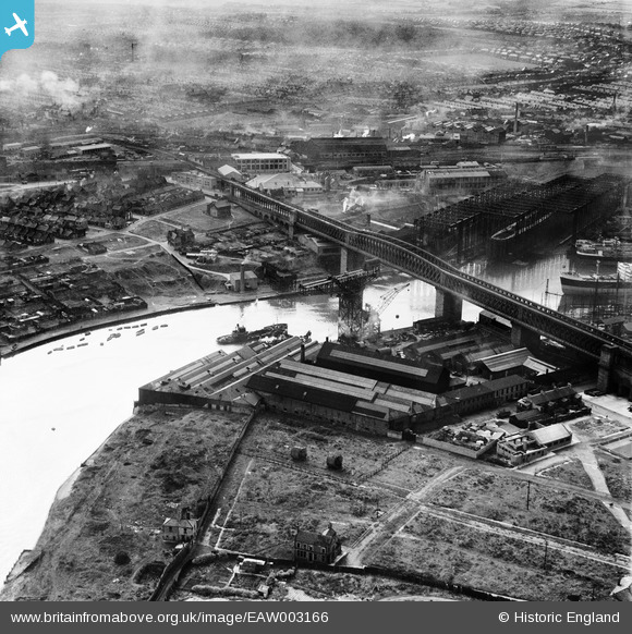
EAW003166 ENGLAND (1946). The Richardsons, Westgarth and Co Marine Engineering Works (G. Clark Ltd) alongside Queen Alexandra Bridge, Sunderland, 1946
© Copyright OpenStreetMap contributors and licensed by the OpenStreetMap Foundation. 2026. Cartography is licensed as CC BY-SA.
Nearby Images (22)
EAW003166
 alongside Queen Alexandra Bridge, Sunderland, 1946")
EPW054629

EAW001032

EAW003164
, Sunderland, from the south-east, 1946")
EAW003155
, Queen Alexandra Bridge and the surrounding area, Sunderland, 1946")
EAW003167
 alongside Queen Alexandra Bridge, Sunderland, 1946")
EAW003163
, Sunderland, 1946")
EAW003154
, Queen Alexandra Bridge and the surrounding industrial area, Sunderland, 1946")
EAW003169
 alongside the Queen Alexandra Bridge, Sunderland, 1946")
EAW003153
, Queen Alexandra Bridge and the surrounding industrial area, Sunderland, 1946")
EAW003150
 alongside Queen Alexandra Bridge, Sunderland, from the north-east, 1946")
EAW003165
, Sunderland, 1946")
EPW057819

EAW003162
 and the surrounding industrial area, Sunderland, from the west, 1946")
EPW054627

EAW003151
 alongside Queen Alexandra Bridge, Sunderland, 1946")
EAW003168
 and the surrounding residential area, Sunderland, 1946")
EPW006528

EPW054626

EAW003156
 alongside Queen Alexandra Bridge, Sunderland, 1946")
EPW054628

EPW006529

Details
| Title | [EAW003166] The Richardsons, Westgarth and Co Marine Engineering Works (G. Clark Ltd) alongside Queen Alexandra Bridge, Sunderland, 1946 |
| Reference | EAW003166 |
| Date | 23-October-1946 |
| Link | |
| Place name | SUNDERLAND |
| Parish | |
| District | |
| Country | ENGLAND |
| Easting / Northing | 438219, 557793 |
| Longitude / Latitude | -1.403757970215, 54.913296610956 |
| National Grid Reference | NZ382578 |
Pins

Matt Aldred edob.mattaldred.com |
Thursday 19th of May 2022 02:16:28 PM |
User Comment Contributions
George Clark Engine Works, Southwick, with Banks of the Wear public house at the very bottom of the photo in the centre. |

Suddicker |
Thursday 24th of July 2014 07:35:58 PM |