
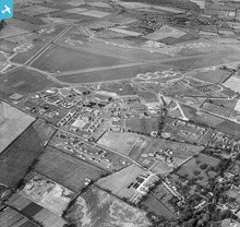
EAW002900 ENGLAND (1946). RAF Horsham St Faith Airfield (Norwich Airport), Norwich, 1946

© Copyright OpenStreetMap contributors and licensed by the OpenStreetMap Foundation. 2026. Cartography is licensed as CC BY-SA.
Nearby Images (4)
EAW002900
, Norwich, 1946")
EAW001955

EAW002905

EAW001957

Details
| Title | [EAW002900] RAF Horsham St Faith Airfield (Norwich Airport), Norwich, 1946 |
| Reference | EAW002900 |
| Date | 1-October-1946 |
| Link | |
| Place name | NORWICH |
| Parish | |
| District | |
| Country | ENGLAND |
| Easting / Northing | 622373, 312761 |
| Longitude / Latitude | 1.2890550905649, 52.666518895724 |
| National Grid Reference | TG224128 |
Pins

redmist |
Thursday 11th of March 2021 08:16:00 PM | |

Matt Aldred edob.mattaldred.com |
Tuesday 24th of November 2020 10:34:48 PM | |
|
Matt Aldred edob.mattaldred.com |
Tuesday 24th of November 2020 10:34:12 PM | |
|
Matt Aldred edob.mattaldred.com |
Tuesday 24th of November 2020 10:33:55 PM | |
|
Matt Aldred edob.mattaldred.com |
Tuesday 24th of November 2020 10:33:32 PM | |
|
Matt Aldred edob.mattaldred.com |
Tuesday 24th of November 2020 10:33:04 PM | |
|
Al |
Monday 6th of January 2014 03:57:09 PM | |
|
cptpies |
Monday 16th of December 2013 03:27:48 PM | |
|
cptpies |
Monday 16th of December 2013 03:24:10 PM | |
|
cptpies |
Monday 16th of December 2013 03:23:29 PM |
User Comment Contributions
RAF Horsham St Faith perimeter defence pillboxes. |
cptpies |
Thursday 19th of December 2013 02:10:46 PM |