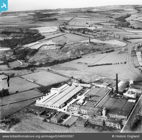
EAW002667 ENGLAND (1946). The Scandinavia Textile Belting Mills and the surrounding area, Cleckheaton, 1946
© Copyright OpenStreetMap contributors and licensed by the OpenStreetMap Foundation. 2025. Cartography is licensed as CC BY-SA.
Nearby Images (19)
Details
| Title | [EAW002667] The Scandinavia Textile Belting Mills and the surrounding area, Cleckheaton, 1946 |
| Reference | EAW002667 |
| Date | 19-September-1946 |
| Link | |
| Place name | CLECKHEATON |
| Parish | |
| District | |
| Country | ENGLAND |
| Easting / Northing | 418581, 426385 |
| Longitude / Latitude | -1.7183047890131, 53.733303294092 |
| National Grid Reference | SE186264 |


![[EAW002667] The Scandinavia Textile Belting Mills and the surrounding area, Cleckheaton, 1946](http://britainfromabove.org.uk/sites/all/libraries/aerofilms-images/public/100x100/EAW/002/EAW002667.jpg)
![[EAW002670] The Scandinavia Textile Belting Mills, Cleckheaton, 1946](http://britainfromabove.org.uk/sites/all/libraries/aerofilms-images/public/100x100/EAW/002/EAW002670.jpg)
![[EAW002666] The Scandinavia Textile Belting Mills, Cleckheaton, 1946](http://britainfromabove.org.uk/sites/all/libraries/aerofilms-images/public/100x100/EAW/002/EAW002666.jpg)
![[EAW002668] The Scandinavia Textile Belting Mills, Hunsworth Lane and the surrounding area, Cleckheaton, 1946](http://britainfromabove.org.uk/sites/all/libraries/aerofilms-images/public/100x100/EAW/002/EAW002668.jpg)
![[EPW040820] The British Belting & Asbestos Ltd Scandinavia Belting Mill, Cleckheaton, 1933](http://britainfromabove.org.uk/sites/all/libraries/aerofilms-images/public/100x100/EPW/040/EPW040820.jpg)
![[EPW040822] The British Belting & Asbestos Ltd Scandinavia Belting Mill, Cleckheaton, 1933](http://britainfromabove.org.uk/sites/all/libraries/aerofilms-images/public/100x100/EPW/040/EPW040822.jpg)
![[EPW040826] The British Belting & Asbestos Ltd Scandinavia Belting Mill and environs, Cleckheaton, 1933](http://britainfromabove.org.uk/sites/all/libraries/aerofilms-images/public/100x100/EPW/040/EPW040826.jpg)
![[EPW040824] The British Belting & Asbestos Ltd Scandinavia Belting Mill and environs, Cleckheaton, 1933](http://britainfromabove.org.uk/sites/all/libraries/aerofilms-images/public/100x100/EPW/040/EPW040824.jpg)
![[EAW002669] The Scandinavia Textile Belting Mills and the town, Cleckheaton, 1946](http://britainfromabove.org.uk/sites/all/libraries/aerofilms-images/public/100x100/EAW/002/EAW002669.jpg)
![[EPW040819] The British Belting & Asbestos Ltd Scandinavia Belting Mill, Cleckheaton, 1933](http://britainfromabove.org.uk/sites/all/libraries/aerofilms-images/public/100x100/EPW/040/EPW040819.jpg)
![[EPW040821] The British Belting & Asbestos Ltd Scandinavia Belting Mill, Cleckheaton, 1933](http://britainfromabove.org.uk/sites/all/libraries/aerofilms-images/public/100x100/EPW/040/EPW040821.jpg)
![[EPW040823] The British Belting & Asbestos Ltd Scandinavia Belting Mill, Cleckheaton, 1933](http://britainfromabove.org.uk/sites/all/libraries/aerofilms-images/public/100x100/EPW/040/EPW040823.jpg)
![[EPW048012] Charles Hirst & Sons Exchange Mills (Steel Wire) and Recreation Ground, Cleckheaton, 1935](http://britainfromabove.org.uk/sites/all/libraries/aerofilms-images/public/100x100/EPW/048/EPW048012.jpg)
![[EPW048006] Charles Hirst & Sons Exchange Mills (Steel Wire) and Recreation Ground, Cleckheaton, 1935](http://britainfromabove.org.uk/sites/all/libraries/aerofilms-images/public/100x100/EPW/048/EPW048006.jpg)
![[EPW048008] Charles Hirst & Sons Exchange Mills (Steel Wire) and Recreation Ground, Cleckheaton, 1935](http://britainfromabove.org.uk/sites/all/libraries/aerofilms-images/public/100x100/EPW/048/EPW048008.jpg)
![[EPW048011] Charles Hirst & Sons Exchange Mills (Steel Wire) and Recreation Ground, Cleckheaton, 1935](http://britainfromabove.org.uk/sites/all/libraries/aerofilms-images/public/100x100/EPW/048/EPW048011.jpg)
![[EPW048007] Charles Hirst & Sons Exchange Mills (Steel Wire) and Recreation Ground, Cleckheaton, 1935](http://britainfromabove.org.uk/sites/all/libraries/aerofilms-images/public/100x100/EPW/048/EPW048007.jpg)
![[EPW048010] Charles Hirst & Sons Exchange Mills (Steel Wire) and Recreation Ground, Cleckheaton, 1935](http://britainfromabove.org.uk/sites/all/libraries/aerofilms-images/public/100x100/EPW/048/EPW048010.jpg)
![[EPW048009] Charles Hirst & Sons Exchange Mills (Steel Wire), Cleckheaton, 1935](http://britainfromabove.org.uk/sites/all/libraries/aerofilms-images/public/100x100/EPW/048/EPW048009.jpg)
