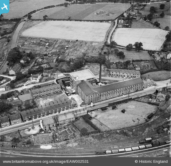
EAW002531 ENGLAND (1946). The J C Naylor & Co Ltd Emery Mills on Hyde Road and environs, Woodley, 1946
© Copyright OpenStreetMap contributors and licensed by the OpenStreetMap Foundation. 2024. Cartography is licensed as CC BY-SA.
Nearby Images (9)
Details
| Title | [EAW002531] The J C Naylor & Co Ltd Emery Mills on Hyde Road and environs, Woodley, 1946 |
| Reference | EAW002531 |
| Date | 10-September-1946 |
| Link | |
| Place name | WOODLEY |
| Parish | |
| District | |
| Country | ENGLAND |
| Easting / Northing | 393761, 392419 |
| Longitude / Latitude | -2.0939070850512, 53.428265522196 |
| National Grid Reference | SJ938924 |
Pins
 redmist |
Thursday 3rd of January 2019 10:04:48 AM | |
 redmist |
Thursday 3rd of January 2019 10:04:16 AM | |
 totoro |
Tuesday 12th of November 2013 01:13:17 PM | |
 totoro |
Tuesday 12th of November 2013 01:10:05 PM | |
 totoro |
Tuesday 12th of November 2013 01:08:13 PM | |
 totoro |
Tuesday 12th of November 2013 01:04:21 PM | |
 totoro |
Tuesday 12th of November 2013 12:49:18 PM | |
 totoro |
Tuesday 12th of November 2013 12:42:17 PM | |
 totoro |
Tuesday 12th of November 2013 12:41:31 PM | |
 totoro |
Tuesday 12th of November 2013 12:32:16 PM | |
 totoro |
Tuesday 12th of November 2013 12:31:46 PM |


![[EAW002531] The J C Naylor & Co Ltd Emery Mills on Hyde Road and environs, Woodley, 1946](http://britainfromabove.org.uk/sites/all/libraries/aerofilms-images/public/100x100/EAW/002/EAW002531.jpg)
![[EAW002751] J.G. Naylor & Co Ltd Woodley Emery Mill, Woodley, 1946](http://britainfromabove.org.uk/sites/all/libraries/aerofilms-images/public/100x100/EAW/002/EAW002751.jpg)
![[EAW002752] J.G. Naylor & Co Ltd Woodley Emery Mill, Woodley, 1946](http://britainfromabove.org.uk/sites/all/libraries/aerofilms-images/public/100x100/EAW/002/EAW002752.jpg)
![[EAW002528] The J C Naylor & Co Ltd Emery Mills on Hyde Road and environs, Woodley, 1946](http://britainfromabove.org.uk/sites/all/libraries/aerofilms-images/public/100x100/EAW/002/EAW002528.jpg)
![[EAW002530] The J C Naylor & Co Ltd Emery Mills on Hyde Road and environs, Woodley, 1946](http://britainfromabove.org.uk/sites/all/libraries/aerofilms-images/public/100x100/EAW/002/EAW002530.jpg)
![[EAW002527] The J C Naylor & Co Ltd Emery Mills on Hyde Road and environs, Woodley, 1946](http://britainfromabove.org.uk/sites/all/libraries/aerofilms-images/public/100x100/EAW/002/EAW002527.jpg)
![[EAW002529] The J C Naylor & Co Ltd Emery Mills on Hyde Road and environs, Woodley, 1946](http://britainfromabove.org.uk/sites/all/libraries/aerofilms-images/public/100x100/EAW/002/EAW002529.jpg)
![[EAW002750] J.G. Naylor & Co Ltd Woodley Emery Mill and environs, Woodley, 1946](http://britainfromabove.org.uk/sites/all/libraries/aerofilms-images/public/100x100/EAW/002/EAW002750.jpg)
![[EAW002753] J.G. Naylor & Co Ltd Woodley Emery Mill and environs, Woodley, 1946](http://britainfromabove.org.uk/sites/all/libraries/aerofilms-images/public/100x100/EAW/002/EAW002753.jpg)