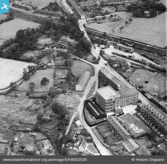
EAW002530 ENGLAND (1946). The J C Naylor & Co Ltd Emery Mills on Hyde Road and environs, Woodley, 1946
© Copyright OpenStreetMap contributors and licensed by the OpenStreetMap Foundation. 2024. Cartography is licensed as CC BY-SA.
Nearby Images (9)
Details
| Title | [EAW002530] The J C Naylor & Co Ltd Emery Mills on Hyde Road and environs, Woodley, 1946 |
| Reference | EAW002530 |
| Date | 10-September-1946 |
| Link | |
| Place name | WOODLEY |
| Parish | |
| District | |
| Country | ENGLAND |
| Easting / Northing | 393785, 392473 |
| Longitude / Latitude | -2.093546912357, 53.428751241743 |
| National Grid Reference | SJ938925 |
Pins
 redmist |
Thursday 3rd of January 2019 03:21:05 PM | |
 redmist |
Thursday 3rd of January 2019 10:03:08 AM | |
 Sparky |
Sunday 17th of September 2017 10:14:36 AM | |
 totoro |
Tuesday 12th of November 2013 01:34:54 PM | |
 totoro |
Tuesday 12th of November 2013 01:23:03 PM | |
 totoro |
Tuesday 12th of November 2013 01:19:31 PM | |
 totoro |
Tuesday 12th of November 2013 01:16:22 PM | |
 totoro |
Tuesday 12th of November 2013 01:14:13 PM |


![[EAW002530] The J C Naylor & Co Ltd Emery Mills on Hyde Road and environs, Woodley, 1946](http://britainfromabove.org.uk/sites/all/libraries/aerofilms-images/public/100x100/EAW/002/EAW002530.jpg)
![[EAW002527] The J C Naylor & Co Ltd Emery Mills on Hyde Road and environs, Woodley, 1946](http://britainfromabove.org.uk/sites/all/libraries/aerofilms-images/public/100x100/EAW/002/EAW002527.jpg)
![[EAW002751] J.G. Naylor & Co Ltd Woodley Emery Mill, Woodley, 1946](http://britainfromabove.org.uk/sites/all/libraries/aerofilms-images/public/100x100/EAW/002/EAW002751.jpg)
![[EAW002752] J.G. Naylor & Co Ltd Woodley Emery Mill, Woodley, 1946](http://britainfromabove.org.uk/sites/all/libraries/aerofilms-images/public/100x100/EAW/002/EAW002752.jpg)
![[EAW002531] The J C Naylor & Co Ltd Emery Mills on Hyde Road and environs, Woodley, 1946](http://britainfromabove.org.uk/sites/all/libraries/aerofilms-images/public/100x100/EAW/002/EAW002531.jpg)
![[EAW002528] The J C Naylor & Co Ltd Emery Mills on Hyde Road and environs, Woodley, 1946](http://britainfromabove.org.uk/sites/all/libraries/aerofilms-images/public/100x100/EAW/002/EAW002528.jpg)
![[EAW002750] J.G. Naylor & Co Ltd Woodley Emery Mill and environs, Woodley, 1946](http://britainfromabove.org.uk/sites/all/libraries/aerofilms-images/public/100x100/EAW/002/EAW002750.jpg)
![[EAW002529] The J C Naylor & Co Ltd Emery Mills on Hyde Road and environs, Woodley, 1946](http://britainfromabove.org.uk/sites/all/libraries/aerofilms-images/public/100x100/EAW/002/EAW002529.jpg)
![[EAW002753] J.G. Naylor & Co Ltd Woodley Emery Mill and environs, Woodley, 1946](http://britainfromabove.org.uk/sites/all/libraries/aerofilms-images/public/100x100/EAW/002/EAW002753.jpg)