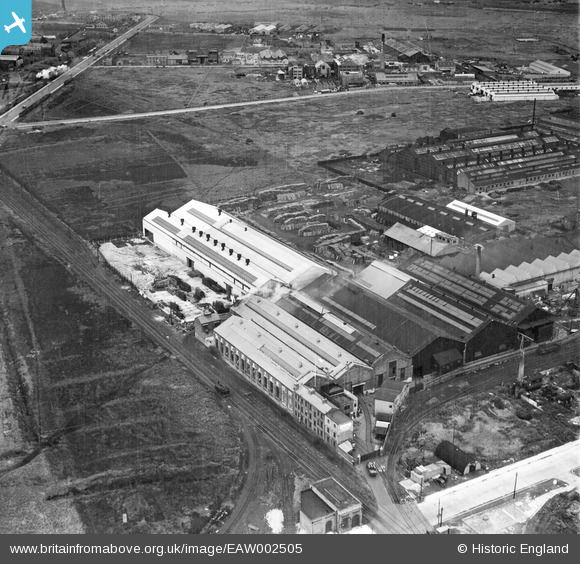
EAW002505 ENGLAND (1946). The Superheater Company Engineering Works and environs, Trafford Park, 1946
© Copyright OpenStreetMap contributors and licensed by the OpenStreetMap Foundation. 2026. Cartography is licensed as CC BY-SA.
Nearby Images (43)
Details
| Title | [EAW002505] The Superheater Company Engineering Works and environs, Trafford Park, 1946 |
| Reference | EAW002505 |
| Date | 10-September-1946 |
| Link | |
| Place name | TRAFFORD PARK |
| Parish | |
| District | |
| Country | ENGLAND |
| Easting / Northing | 378898, 397052 |
| Longitude / Latitude | -2.3179277755873, 53.469528058981 |
| National Grid Reference | SJ789971 |
Pins

redmist |
Wednesday 25th of January 2023 10:38:29 PM |


![[EAW002505] The Superheater Company Engineering Works and environs, Trafford Park, 1946](http://britainfromabove.org.uk/sites/all/libraries/aerofilms-images/public/100x100/EAW/002/EAW002505.jpg)
![[EAW050190] The Superheater Co Ltd Engineering Works and other factories, Trafford Park, 1953. This image was marked by Aerofilms Ltd for photo editing.](http://britainfromabove.org.uk/sites/all/libraries/aerofilms-images/public/100x100/EAW/050/EAW050190.jpg)
![[EAW002502] The Superheater Company Engineering Works and environs, Trafford Park, from the south, 1946](http://britainfromabove.org.uk/sites/all/libraries/aerofilms-images/public/100x100/EAW/002/EAW002502.jpg)
![[EAW050191] The Superheater Co Ltd Engineering Works and other factories, Trafford Park, 1953. This image was marked by Aerofilms Ltd for photo editing.](http://britainfromabove.org.uk/sites/all/libraries/aerofilms-images/public/100x100/EAW/050/EAW050191.jpg)
![[EAW050192] The Superheater Co Ltd Engineering Works and other factories, Trafford Park, 1953. This image was marked by Aerofilms Ltd for photo editing.](http://britainfromabove.org.uk/sites/all/libraries/aerofilms-images/public/100x100/EAW/050/EAW050192.jpg)
![[EAW002498] The Superheater Company Engineering Works and environs, Trafford Park, 1946](http://britainfromabove.org.uk/sites/all/libraries/aerofilms-images/public/100x100/EAW/002/EAW002498.jpg)
![[EAW050188] The Superheater Co Ltd Engineering Works and other factories, Trafford Park, 1953. This image was marked by Aerofilms Ltd for photo editing.](http://britainfromabove.org.uk/sites/all/libraries/aerofilms-images/public/100x100/EAW/050/EAW050188.jpg)
![[EAW050195] The Superheater Co Ltd Engineering Works and other factories, Trafford Park, 1953. This image was marked by Aerofilms Ltd for photo editing.](http://britainfromabove.org.uk/sites/all/libraries/aerofilms-images/public/100x100/EAW/050/EAW050195.jpg)
![[EAW050187] The Superheater Co Ltd Engineering Works and other factories, Trafford Park, 1953. This image was marked by Aerofilms Ltd for photo editing.](http://britainfromabove.org.uk/sites/all/libraries/aerofilms-images/public/100x100/EAW/050/EAW050187.jpg)
![[EAW002503] The Superheater Company Engineering Works and environs, Trafford Park, from the south-east, 1946](http://britainfromabove.org.uk/sites/all/libraries/aerofilms-images/public/100x100/EAW/002/EAW002503.jpg)
![[EPW053320] The Superheater Company Engineering Works, Trafford Park, 1937](http://britainfromabove.org.uk/sites/all/libraries/aerofilms-images/public/100x100/EPW/053/EPW053320.jpg)
![[EAW002500] The Superheater Company Engineering Works and environs, Trafford Park, from the south-west, 1946](http://britainfromabove.org.uk/sites/all/libraries/aerofilms-images/public/100x100/EAW/002/EAW002500.jpg)
![[EPW053319] The Superheater Company Engineering Works, Trafford Park, 1937](http://britainfromabove.org.uk/sites/all/libraries/aerofilms-images/public/100x100/EPW/053/EPW053319.jpg)
![[EAW002504] The Superheater Company Engineering Works and environs, Trafford Park, 1946](http://britainfromabove.org.uk/sites/all/libraries/aerofilms-images/public/100x100/EAW/002/EAW002504.jpg)
![[EPW053318] The Superheater Company Engineering Works and environs, Trafford Park, 1937](http://britainfromabove.org.uk/sites/all/libraries/aerofilms-images/public/100x100/EPW/053/EPW053318.jpg)
![[EPW053323] The Superheater Company Engineering Works, Trafford Park, 1937](http://britainfromabove.org.uk/sites/all/libraries/aerofilms-images/public/100x100/EPW/053/EPW053323.jpg)
![[EPW053322] The Superheater Company Engineering Works, Trafford Park, 1937](http://britainfromabove.org.uk/sites/all/libraries/aerofilms-images/public/100x100/EPW/053/EPW053322.jpg)
![[EAW050193] The Superheater Co Ltd Engineering Works and other factories, Trafford Park, 1953. This image was marked by Aerofilms Ltd for photo editing.](http://britainfromabove.org.uk/sites/all/libraries/aerofilms-images/public/100x100/EAW/050/EAW050193.jpg)
![[EPW053317] The Superheater Company Engineering Works, Trafford Park, 1937](http://britainfromabove.org.uk/sites/all/libraries/aerofilms-images/public/100x100/EPW/053/EPW053317.jpg)
![[EAW050189] The Superheater Co Ltd Engineering Works and other factories, Trafford Park, 1953. This image was marked by Aerofilms Ltd for photo editing.](http://britainfromabove.org.uk/sites/all/libraries/aerofilms-images/public/100x100/EAW/050/EAW050189.jpg)
![[EPW053321] The Superheater Company Engineering Works, Trafford Park, 1937](http://britainfromabove.org.uk/sites/all/libraries/aerofilms-images/public/100x100/EPW/053/EPW053321.jpg)
![[EAW002501] The Superheater Company Engineering Works and environs, Trafford Park, 1946](http://britainfromabove.org.uk/sites/all/libraries/aerofilms-images/public/100x100/EAW/002/EAW002501.jpg)
![[EPW009624] Engineering Works and warehouses, Trafford Park, 1923](http://britainfromabove.org.uk/sites/all/libraries/aerofilms-images/public/100x100/EPW/009/EPW009624.jpg)
![[EPW009625] Engineering Works and warehouses, Trafford Park, 1923](http://britainfromabove.org.uk/sites/all/libraries/aerofilms-images/public/100x100/EPW/009/EPW009625.jpg)
![[EPW027467] The Superheater Company Engineering Works and environs, Trafford Park, 1929](http://britainfromabove.org.uk/sites/all/libraries/aerofilms-images/public/100x100/EPW/027/EPW027467.jpg)
![[EPW009622] Engineering Works, Trafford Park, 1923](http://britainfromabove.org.uk/sites/all/libraries/aerofilms-images/public/100x100/EPW/009/EPW009622.jpg)
![[EPW009623] Engineering Works and warehouses, Trafford Park, 1923](http://britainfromabove.org.uk/sites/all/libraries/aerofilms-images/public/100x100/EPW/009/EPW009623.jpg)
![[EPW009668] Engineering Works and warehouses, Trafford Park, 1923](http://britainfromabove.org.uk/sites/all/libraries/aerofilms-images/public/100x100/EPW/009/EPW009668.jpg)
![[EAW050194] The Superheater Co Ltd Engineering Works and other factories, Trafford Park, 1953. This image was marked by Aerofilms Ltd for photo editing.](http://britainfromabove.org.uk/sites/all/libraries/aerofilms-images/public/100x100/EAW/050/EAW050194.jpg)
![[EPW009626] Engineering Works, Wire Works and warehouses, Trafford Park, 1923](http://britainfromabove.org.uk/sites/all/libraries/aerofilms-images/public/100x100/EPW/009/EPW009626.jpg)
![[EPW027464] Works and Warehouses off Trafford Park Road, Trafford Park, 1929](http://britainfromabove.org.uk/sites/all/libraries/aerofilms-images/public/100x100/EPW/027/EPW027464.jpg)
![[EPW009621] Engineering Works, Wire Works and warehouses, Trafford Park, 1923](http://britainfromabove.org.uk/sites/all/libraries/aerofilms-images/public/100x100/EPW/009/EPW009621.jpg)
![[EAW002497] The Superheater Company Engineering Works and environs, Trafford Park, 1946](http://britainfromabove.org.uk/sites/all/libraries/aerofilms-images/public/100x100/EAW/002/EAW002497.jpg)
![[EAW002499] The Superheater Company Engineering Works and environs, Trafford Park, 1946](http://britainfromabove.org.uk/sites/all/libraries/aerofilms-images/public/100x100/EAW/002/EAW002499.jpg)
![[EAW036240] London Electric Wire Co and Smiths Ltd Anaconda Copper and Bronze Wire Mills, Trafford Park, 1951. This image has been produced from a print marked by Aerofilms Ltd for photo editing.](http://britainfromabove.org.uk/sites/all/libraries/aerofilms-images/public/100x100/EAW/036/EAW036240.jpg)
![[EAW036241] London Electric Wire Co and Smiths Ltd Anaconda Copper and Bronze Wire Mills, Trafford Park, 1951. This image has been produced from a print marked by Aerofilms Ltd for photo editing.](http://britainfromabove.org.uk/sites/all/libraries/aerofilms-images/public/100x100/EAW/036/EAW036241.jpg)
![[EAW036239] London Electric Wire Co and Smiths Ltd Anaconda Copper and Bronze Wire Mills, Trafford Park, 1951. This image has been produced from a print marked by Aerofilms Ltd for photo editing.](http://britainfromabove.org.uk/sites/all/libraries/aerofilms-images/public/100x100/EAW/036/EAW036239.jpg)
![[EAW036242] London Electric Wire Co and Smiths Ltd Anaconda Copper and Bronze Wire Mills, Trafford Park, 1951. This image has been produced from a print.](http://britainfromabove.org.uk/sites/all/libraries/aerofilms-images/public/100x100/EAW/036/EAW036242.jpg)
![[EAW036243] London Electric Wire Co and Smiths Ltd Anaconda Copper and Bronze Wire Mills, Trafford Park, 1951. This image has been produced from a print.](http://britainfromabove.org.uk/sites/all/libraries/aerofilms-images/public/100x100/EAW/036/EAW036243.jpg)
![[EAW036238] London Electric Wire Co and Smiths Ltd Anaconda Copper and Bronze Wire Mills, Trafford Park, 1951. This image has been produced from a print marked by Aerofilms Ltd for photo editing.](http://britainfromabove.org.uk/sites/all/libraries/aerofilms-images/public/100x100/EAW/036/EAW036238.jpg)
![[EAW036244] London Electric Wire Co and Smiths Ltd Anaconda Copper and Bronze Wire Mills, Trafford Park, 1951. This image has been produced from a print.](http://britainfromabove.org.uk/sites/all/libraries/aerofilms-images/public/100x100/EAW/036/EAW036244.jpg)
![[EPW009619] The Ocean Iron Works and Anaconda Mills, Trafford Park, 1923](http://britainfromabove.org.uk/sites/all/libraries/aerofilms-images/public/100x100/EPW/009/EPW009619.jpg)
![[EAW036245] London Electric Wire Co and Smiths Ltd Anaconda Copper and Bronze Wire Mills, Trafford Park, 1951. This image has been produced from a print.](http://britainfromabove.org.uk/sites/all/libraries/aerofilms-images/public/100x100/EAW/036/EAW036245.jpg)