
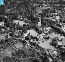
EAW002353 ENGLAND (1946). Kippington Court (Churchill Court) and St Mary's Church, Kippington, 1946

© Copyright OpenStreetMap contributors and licensed by the OpenStreetMap Foundation. 2026. Cartography is licensed as CC BY-SA.
Nearby Images (9)
EAW002353
 and St Mary's Church, Kippington, 1946")
EAW002357
, Kippington, 1946")
EAW002350
, Kippington, 1946")
EAW002351
, Kippington, 1946")
EAW002352
 and environs, Kippington, 1946")
EAW002354
 and environs, Kippington, from the west, 1946")
EAW002355
 and environs, Kippington, from the south, 1946")
EPW001427

EAW002356
 and environs, Kippington, from the south-west, 1946")
Details
| Title | [EAW002353] Kippington Court (Churchill Court) and St Mary's Church, Kippington, 1946 |
| Reference | EAW002353 |
| Date | 9-September-1946 |
| Link | |
| Place name | KIPPINGTON |
| Parish | SEVENOAKS |
| District | |
| Country | ENGLAND |
| Easting / Northing | 552093, 154639 |
| Longitude / Latitude | 0.18050973294068, 51.270068726725 |
| National Grid Reference | TQ521546 |
Pins

User Comment Contributions
Kippington War Memorial on the grassed area between the church and the road. See http://www.kentfallen.com/PDF%20REPORTS/KIPPINGTON.pdf. |

Susan F |
Monday 6th of October 2014 11:21:11 PM |