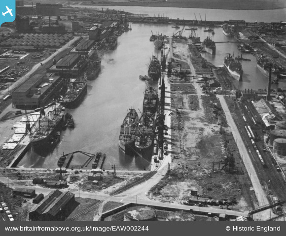
EAW002244 ENGLAND (1946). The Port of Bristol Authority Royal Edward Docks, Avonmouth, 1946. This image has been produced from a print.
© Copyright OpenStreetMap contributors and licensed by the OpenStreetMap Foundation. 2026. Cartography is licensed as CC BY-SA.
Nearby Images (9)
Details
| Title | [EAW002244] The Port of Bristol Authority Royal Edward Docks, Avonmouth, 1946. This image has been produced from a print. |
| Reference | EAW002244 |
| Date | 18-August-1946 |
| Link | |
| Place name | AVONMOUTH |
| Parish | |
| District | |
| Country | ENGLAND |
| Easting / Northing | 351489, 179498 |
| Longitude / Latitude | -2.6991296414465, 51.511841472778 |
| National Grid Reference | ST515795 |
Pins

redmist |
Tuesday 10th of November 2020 11:45:31 PM | |

Matt Aldred edob.mattaldred.com |
Sunday 8th of November 2020 10:34:43 PM | |

Matt Aldred edob.mattaldred.com |
Sunday 8th of November 2020 10:33:40 PM | |

Matt Aldred edob.mattaldred.com |
Sunday 8th of November 2020 10:33:17 PM | |

Sparky |
Saturday 10th of August 2019 08:09:25 PM | |

Sparky |
Saturday 10th of August 2019 08:08:33 PM |


![[EAW002244] The Port of Bristol Authority Royal Edward Docks, Avonmouth, 1946. This image has been produced from a print.](http://britainfromabove.org.uk/sites/all/libraries/aerofilms-images/public/100x100/EAW/002/EAW002244.jpg)
![[EAW002074] The Eastern Arm at Avonmouth Docks, Avonmouth, 1946. This image has been produced from a print.](http://britainfromabove.org.uk/sites/all/libraries/aerofilms-images/public/100x100/EAW/002/EAW002074.jpg)
![[EAW002252] The Port of Bristol Authority Royal Edward Docks, Avonmouth, 1946. This image has been produced from a print.](http://britainfromabove.org.uk/sites/all/libraries/aerofilms-images/public/100x100/EAW/002/EAW002252.jpg)
![[EAW002245] The Port of Bristol Authority Royal Edward Docks, Avonmouth, 1946](http://britainfromabove.org.uk/sites/all/libraries/aerofilms-images/public/100x100/EAW/002/EAW002245.jpg)
![[EAW002251] The Port of Bristol Authority Royal Edward Docks, Avonmouth, from the north-east, 1946. This image has been produced from a print.](http://britainfromabove.org.uk/sites/all/libraries/aerofilms-images/public/100x100/EAW/002/EAW002251.jpg)
![[EAW002248] The Port of Bristol Authority Royal Edward Docks, Avonmouth, 1946. This image has been produced from a print.](http://britainfromabove.org.uk/sites/all/libraries/aerofilms-images/public/100x100/EAW/002/EAW002248.jpg)
![[EPW005486] The Great Western Railway Yard and Battery Farm, Avonmouth, 1921](http://britainfromabove.org.uk/sites/all/libraries/aerofilms-images/public/100x100/EPW/005/EPW005486.jpg)
![[EPR000056] The fuel storage depot opposite the Avonmouth Works, Avonmouth, 1934](http://britainfromabove.org.uk/sites/all/libraries/aerofilms-images/public/100x100/EPR/000/EPR000056.jpg)
![[EPW019264] The National Smelting Company Avonmouth Works and the Avonmouth Docks, Avonmouth, 1927](http://britainfromabove.org.uk/sites/all/libraries/aerofilms-images/public/100x100/EPW/019/EPW019264.jpg)