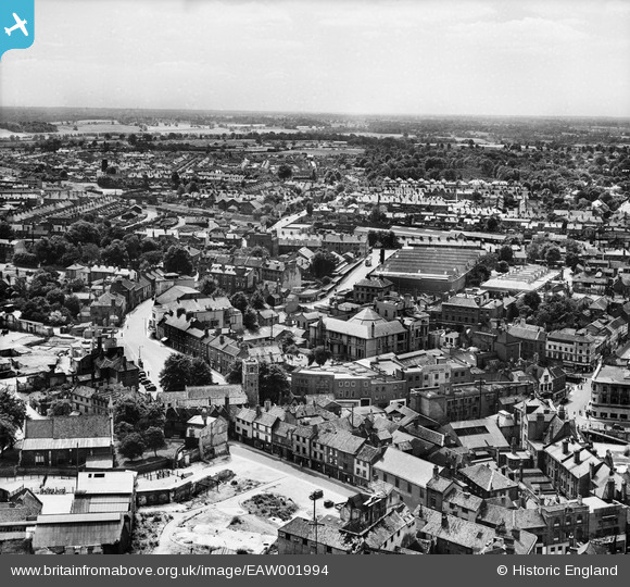
EAW001994 ENGLAND (1946). The Norwich Union offices on Surrey Street, Norwich, from the north, 1946
© Copyright OpenStreetMap contributors and licensed by the OpenStreetMap Foundation. 2026. Cartography is licensed as CC BY-SA.
Nearby Images (33)
Details
| Title | [EAW001994] The Norwich Union offices on Surrey Street, Norwich, from the north, 1946 |
| Reference | EAW001994 |
| Date | 25-July-1946 |
| Link | |
| Place name | NORWICH |
| Parish | |
| District | |
| Country | ENGLAND |
| Easting / Northing | 623111, 308283 |
| Longitude / Latitude | 1.2969235700967, 52.626021865319 |
| National Grid Reference | TG231083 |
Pins

Chris Lambert |
Saturday 27th of August 2022 02:21:53 PM | |

Chris Lambert |
Saturday 27th of August 2022 02:20:04 PM |


![[EAW001994] The Norwich Union offices on Surrey Street, Norwich, from the north, 1946](http://britainfromabove.org.uk/sites/all/libraries/aerofilms-images/public/100x100/EAW/001/EAW001994.jpg)
![[EPW001970A] General view of the town centre, Norwich, from the west, 1920](http://britainfromabove.org.uk/sites/all/libraries/aerofilms-images/public/100x100/EPW/001/EPW001970A.jpg)
![[EAW002004] The Norwich Union offices on Surrey Street and environs, Norwich, 1946](http://britainfromabove.org.uk/sites/all/libraries/aerofilms-images/public/100x100/EAW/002/EAW002004.jpg)
![[EAW002003] The Norwich Union offices on Surrey Street and environs, Norwich, 1946](http://britainfromabove.org.uk/sites/all/libraries/aerofilms-images/public/100x100/EAW/002/EAW002003.jpg)
![[EAW001998] The Norwich Union offices on Surrey Street and environs, Norwich, 1946](http://britainfromabove.org.uk/sites/all/libraries/aerofilms-images/public/100x100/EAW/001/EAW001998.jpg)
![[EAW001992] The Norwich Union offices on Surrey Street and environs, Norwich, 1946](http://britainfromabove.org.uk/sites/all/libraries/aerofilms-images/public/100x100/EAW/001/EAW001992.jpg)
![[EAW037292] Gentleman's Walk and the city centre, Norwich, 1951. This image has been produced from a print.](http://britainfromabove.org.uk/sites/all/libraries/aerofilms-images/public/100x100/EAW/037/EAW037292.jpg)
![[EPW021203] The Castle and town centre, Norwich, 1928](http://britainfromabove.org.uk/sites/all/libraries/aerofilms-images/public/100x100/EPW/021/EPW021203.jpg)
![[EPW001766] Norwich Castle and Cattle market, Norwich, 1920](http://britainfromabove.org.uk/sites/all/libraries/aerofilms-images/public/100x100/EPW/001/EPW001766.jpg)
![[EAW002001] The Norwich Union offices and the Eastern Counties bus depot, Norwich, 1946](http://britainfromabove.org.uk/sites/all/libraries/aerofilms-images/public/100x100/EAW/002/EAW002001.jpg)
![[EAW001991] The Norwich Union offices on Surrey Street and environs, Norwich, 1946](http://britainfromabove.org.uk/sites/all/libraries/aerofilms-images/public/100x100/EAW/001/EAW001991.jpg)
![[EAW001996] The Norwich Union offices and the Eastern Counties bus depot and environs, Norwich, 1946](http://britainfromabove.org.uk/sites/all/libraries/aerofilms-images/public/100x100/EAW/001/EAW001996.jpg)
![[EAW001993] The Norwich Union offices on Surrey Street and the city centre, Norwich, from the south, 1946](http://britainfromabove.org.uk/sites/all/libraries/aerofilms-images/public/100x100/EAW/001/EAW001993.jpg)
![[EAW008142] Norwich Castle, Norwich, 1947](http://britainfromabove.org.uk/sites/all/libraries/aerofilms-images/public/100x100/EAW/008/EAW008142.jpg)
![[EAW001999] The Norwich Union offices and the Eastern Counties bus depot and environs, Norwich, 1946](http://britainfromabove.org.uk/sites/all/libraries/aerofilms-images/public/100x100/EAW/001/EAW001999.jpg)
![[EAW008137] Norwich Castle, Norwich, 1947. This image has been produced from a print.](http://britainfromabove.org.uk/sites/all/libraries/aerofilms-images/public/100x100/EAW/008/EAW008137.jpg)
![[EAW037289] The Castle, Norwich, 1951. This image has been produced from a print.](http://britainfromabove.org.uk/sites/all/libraries/aerofilms-images/public/100x100/EAW/037/EAW037289.jpg)
![[EAW024400] Norwich Castle and the city centre, Norwich, 1949](http://britainfromabove.org.uk/sites/all/libraries/aerofilms-images/public/100x100/EAW/024/EAW024400.jpg)
![[EAW036845] The Castle and environs, Norwich, 1951. This image has been produced from a print.](http://britainfromabove.org.uk/sites/all/libraries/aerofilms-images/public/100x100/EAW/036/EAW036845.jpg)
![[EAW024399] Norwich Castle and environs, Norwich, from the west, 1949](http://britainfromabove.org.uk/sites/all/libraries/aerofilms-images/public/100x100/EAW/024/EAW024399.jpg)
![[EAW001995] The Norwich Union offices and the Eastern Counties bus depot, Norwich, 1946](http://britainfromabove.org.uk/sites/all/libraries/aerofilms-images/public/100x100/EAW/001/EAW001995.jpg)
![[EAW037291] The Castle, City Hall and city centre, Norwich, 1951. This image has been produced from a print.](http://britainfromabove.org.uk/sites/all/libraries/aerofilms-images/public/100x100/EAW/037/EAW037291.jpg)
![[EAW008140] Norwich Castle and environs, Norwich, 1947. This image has been produced from a print.](http://britainfromabove.org.uk/sites/all/libraries/aerofilms-images/public/100x100/EAW/008/EAW008140.jpg)
![[EAW008138] Norwich Castle, Norwich, 1947. This image has been produced from a print.](http://britainfromabove.org.uk/sites/all/libraries/aerofilms-images/public/100x100/EAW/008/EAW008138.jpg)
![[EPW001970] General view of the town centre, Norwich, from the south-west, 1920](http://britainfromabove.org.uk/sites/all/libraries/aerofilms-images/public/100x100/EPW/001/EPW001970.jpg)
![[EAW002895] Norwich Castle Museum, the City Hall and the city centre, Norwich, 1946](http://britainfromabove.org.uk/sites/all/libraries/aerofilms-images/public/100x100/EAW/002/EAW002895.jpg)
![[EPW021212] The Market Place and Castle, Norwich, 1928](http://britainfromabove.org.uk/sites/all/libraries/aerofilms-images/public/100x100/EPW/021/EPW021212.jpg)
![[EAW002002] The Norwich Union offices and the Eastern Counties bus depot and environs, Norwich, 1946](http://britainfromabove.org.uk/sites/all/libraries/aerofilms-images/public/100x100/EAW/002/EAW002002.jpg)
![[EAW002000] The Norwich Union offices and the Eastern Counties bus depot and environs, Norwich, 1946](http://britainfromabove.org.uk/sites/all/libraries/aerofilms-images/public/100x100/EAW/002/EAW002000.jpg)
![[EAW037290] The Castle, Market Place and City Hall, Norwich, 1951. This image has been produced from a print.](http://britainfromabove.org.uk/sites/all/libraries/aerofilms-images/public/100x100/EAW/037/EAW037290.jpg)
![[EAW008139] Norwich Castle, Norwich, 1947. This image has been produced from a print.](http://britainfromabove.org.uk/sites/all/libraries/aerofilms-images/public/100x100/EAW/008/EAW008139.jpg)
![[EAW001997] The Norwich Union offices and the Eastern Counties bus depot and environs, Norwich, 1946](http://britainfromabove.org.uk/sites/all/libraries/aerofilms-images/public/100x100/EAW/001/EAW001997.jpg)
![[EAW008200] The cattle market and environs, Norwich, 1947](http://britainfromabove.org.uk/sites/all/libraries/aerofilms-images/public/100x100/EAW/008/EAW008200.jpg)