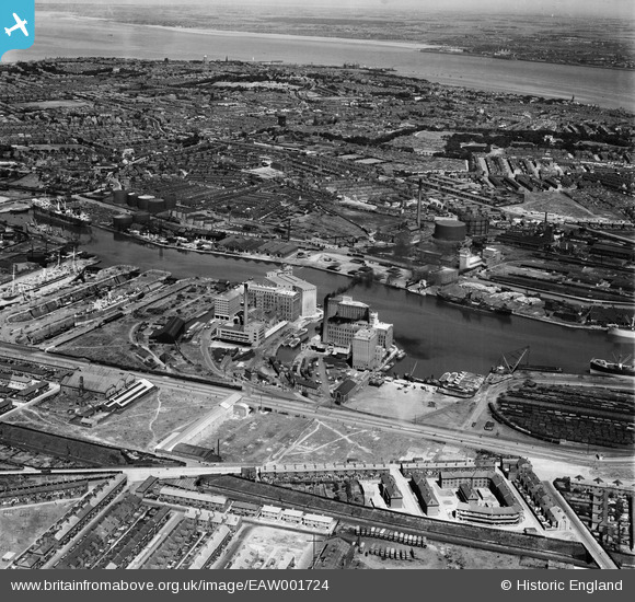
EAW001724 ENGLAND (1946). Gilbrook Basin, the West Float and environs, Birkenhead, 1946
© Copyright OpenStreetMap contributors and licensed by the OpenStreetMap Foundation. 2026. Cartography is licensed as CC BY-SA.
Nearby Images (23)
Details
| Title | [EAW001724] Gilbrook Basin, the West Float and environs, Birkenhead, 1946 |
| Reference | EAW001724 |
| Date | 11-July-1946 |
| Link | |
| Place name | BIRKENHEAD |
| Parish | |
| District | |
| Country | ENGLAND |
| Easting / Northing | 330409, 390353 |
| Longitude / Latitude | -3.0469061887411, 53.405140985572 |
| National Grid Reference | SJ304904 |
Pins

TheCreteFleet |
Tuesday 28th of January 2025 07:23:38 PM | |

TheCreteFleet |
Tuesday 28th of January 2025 07:23:16 PM | |

Kylix |
Saturday 14th of September 2024 08:31:59 PM | |

XMAS DAY |
Friday 26th of April 2024 08:18:33 AM | |

SDIrwin |
Sunday 2nd of October 2022 08:38:01 PM | |

Sparky |
Friday 22nd of September 2017 12:24:24 AM | |

Sparky |
Friday 22nd of September 2017 12:23:39 AM | |

Sparky |
Friday 22nd of September 2017 12:22:55 AM | |

Sparky |
Friday 22nd of September 2017 12:21:14 AM | |

MB |
Monday 26th of September 2016 11:06:45 AM | |

Mercury |
Sunday 29th of November 2015 12:33:42 PM | |

Mercury |
Sunday 29th of November 2015 12:28:52 PM | |

ken |
Thursday 18th of June 2015 08:03:25 PM | |

Kylix |
Wednesday 18th of June 2014 03:57:10 AM | |

Pete65 |
Sunday 23rd of February 2014 02:01:40 AM | |

Pete65 |
Sunday 23rd of February 2014 02:00:33 AM | |

Pete65 |
Sunday 23rd of February 2014 01:56:51 AM |


![[EAW001724] Gilbrook Basin, the West Float and environs, Birkenhead, 1946](http://britainfromabove.org.uk/sites/all/libraries/aerofilms-images/public/100x100/EAW/001/EAW001724.jpg)
![[EAW036051] Joseph Rank Ltd Ocean Flour Mills, Birkenhead, 1951. This image has been produced from a print.](http://britainfromabove.org.uk/sites/all/libraries/aerofilms-images/public/100x100/EAW/036/EAW036051.jpg)
![[EAW036054] Joseph Rank Ltd Ocean Flour Mills, Birkenhead, 1951. This image has been produced from a print.](http://britainfromabove.org.uk/sites/all/libraries/aerofilms-images/public/100x100/EAW/036/EAW036054.jpg)
![[EAW038501] The Joseph Rank Ltd Ocean Flour Mills, Poulton, 1951. This image has been produced from a damaged negative.](http://britainfromabove.org.uk/sites/all/libraries/aerofilms-images/public/100x100/EAW/038/EAW038501.jpg)
![[EAW038507] The Joseph Rank Ltd Ocean Flour Mills, Poulton, 1951. This image has been produced from a print marked by Aerofilms Ltd for photo editing.](http://britainfromabove.org.uk/sites/all/libraries/aerofilms-images/public/100x100/EAW/038/EAW038507.jpg)
![[EAW036050] Joseph Rank Ltd Ocean Flour Mills, Birkenhead, 1951. This image has been produced from a print.](http://britainfromabove.org.uk/sites/all/libraries/aerofilms-images/public/100x100/EAW/036/EAW036050.jpg)
![[EPW041994] West Float, Birkenhead, 1933](http://britainfromabove.org.uk/sites/all/libraries/aerofilms-images/public/100x100/EPW/041/EPW041994.jpg)
![[EAW036053] Joseph Rank Ltd Ocean Flour Mills, Birkenhead, 1951. This image has been produced from a print.](http://britainfromabove.org.uk/sites/all/libraries/aerofilms-images/public/100x100/EAW/036/EAW036053.jpg)
![[EAW038504] The Joseph Rank Ltd Ocean Flour Mills, Poulton, 1951. This image has been produced from a print marked by Aerofilms Ltd for photo editing.](http://britainfromabove.org.uk/sites/all/libraries/aerofilms-images/public/100x100/EAW/038/EAW038504.jpg)
![[EAW036048] Joseph Rank Ltd Ocean Flour Mills, Birkenhead, 1951. This image has been produced from a print.](http://britainfromabove.org.uk/sites/all/libraries/aerofilms-images/public/100x100/EAW/036/EAW036048.jpg)
![[EAW038503] The Joseph Rank Ltd Ocean Flour Mills and environs, Poulton, from the north-east, 1951. This image has been produced from a print marked by Aerofilms Ltd for photo editing.](http://britainfromabove.org.uk/sites/all/libraries/aerofilms-images/public/100x100/EAW/038/EAW038503.jpg)
![[EAW038508] The Joseph Rank Ltd Ocean Flour Mills, Poulton, 1951. This image has been produced from a print marked by Aerofilms Ltd for photo editing.](http://britainfromabove.org.uk/sites/all/libraries/aerofilms-images/public/100x100/EAW/038/EAW038508.jpg)
![[EAW036052] Joseph Rank Ltd Ocean Flour Mills, Birkenhead, 1951. This image has been produced from a print.](http://britainfromabove.org.uk/sites/all/libraries/aerofilms-images/public/100x100/EAW/036/EAW036052.jpg)
![[EAW036049] Joseph Rank Ltd Ocean Flour Mills and Gill Basin Dock, Birkenhead, 1951. This image has been produced from a print.](http://britainfromabove.org.uk/sites/all/libraries/aerofilms-images/public/100x100/EAW/036/EAW036049.jpg)
![[EAW038502] The Joseph Rank Ltd Ocean Flour Mills alongside Spillers Flour Mill, Poulton, 1951. This image has been produced from a print marked by Aerofilms Ltd for photo editing.](http://britainfromabove.org.uk/sites/all/libraries/aerofilms-images/public/100x100/EAW/038/EAW038502.jpg)
![[EAW038500] The Joseph Rank Ltd Ocean Flour Mills, Poulton, 1951. This image has been produced from a damaged negative.](http://britainfromabove.org.uk/sites/all/libraries/aerofilms-images/public/100x100/EAW/038/EAW038500.jpg)
![[EPW041996] James Grandidge Ltd timber wharf on West Float, Birkenhead, 1933](http://britainfromabove.org.uk/sites/all/libraries/aerofilms-images/public/100x100/EPW/041/EPW041996.jpg)
![[EAW038505] The Joseph Rank Ltd Ocean Flour Mills, Poulton, 1951. This image has been produced from a print marked by Aerofilms Ltd for photo editing.](http://britainfromabove.org.uk/sites/all/libraries/aerofilms-images/public/100x100/EAW/038/EAW038505.jpg)
![[EPW041997] James Grandidge Ltd timber wharf on West Float, Birkenhead, 1933](http://britainfromabove.org.uk/sites/all/libraries/aerofilms-images/public/100x100/EPW/041/EPW041997.jpg)
![[EPW041995] James Grandidge Ltd timber wharf on West Float, Birkenhead, 1933](http://britainfromabove.org.uk/sites/all/libraries/aerofilms-images/public/100x100/EPW/041/EPW041995.jpg)
![[EPW009282] The Flour Mills and Gas Works, Seacombe, 1923](http://britainfromabove.org.uk/sites/all/libraries/aerofilms-images/public/100x100/EPW/009/EPW009282.jpg)
![[EAW001790] Gilbrook Basin, the West Float and environs, Birkenhead, 1946. This image has been produced from a print.](http://britainfromabove.org.uk/sites/all/libraries/aerofilms-images/public/100x100/EAW/001/EAW001790.jpg)
![[EAW038506] The Joseph Rank Ltd Ocean Flour Mills and Cavendish Wharf, Poulton, 1951. This image has been produced from a print marked by Aerofilms Ltd for photo editing.](http://britainfromabove.org.uk/sites/all/libraries/aerofilms-images/public/100x100/EAW/038/EAW038506.jpg)
