
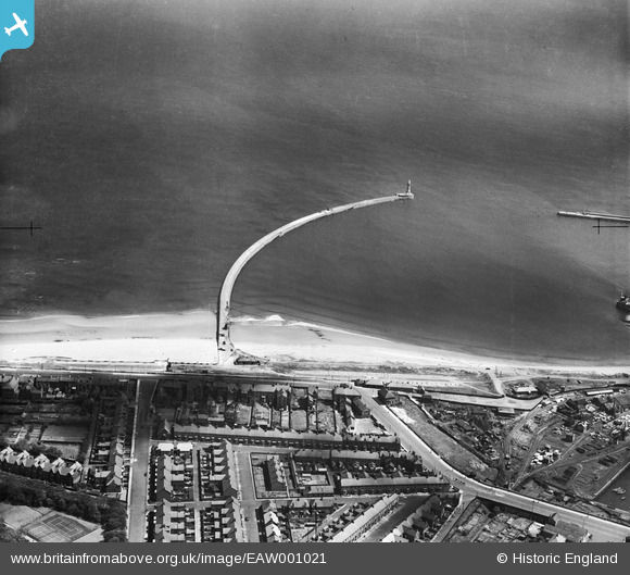
EAW001021 ENGLAND (1946). Roker Pier and Lighthouse, Sunderland, 1946
© Copyright OpenStreetMap contributors and licensed by the OpenStreetMap Foundation. 2026. Cartography is licensed as CC BY-SA.
Nearby Images (2)
EAW001021

EPW051132

Details
| Title | [EAW001021] Roker Pier and Lighthouse, Sunderland, 1946 |
| Reference | EAW001021 |
| Date | 6-June-1946 |
| Link | |
| Place name | SUNDERLAND |
| Parish | |
| District | |
| Country | ENGLAND |
| Easting / Northing | 441146, 558786 |
| Longitude / Latitude | -1.3579558331265, 54.921987903049 |
| National Grid Reference | NZ411588 |
Pins

Matt Aldred edob.mattaldred.com |
Tuesday 12th of August 2025 12:01:36 PM | |
|
Matt Aldred edob.mattaldred.com |
Sunday 28th of February 2021 08:38:25 AM | |

redmist |
Thursday 24th of September 2020 08:16:25 PM | |
|
redmist |
Monday 17th of February 2020 05:03:32 PM | |
|
Coops |
Thursday 10th of March 2016 08:01:08 AM | |
|
Coops |
Thursday 10th of March 2016 08:00:35 AM | |
|
Coops |
Thursday 10th of March 2016 07:59:18 AM | |
|
Coops |
Thursday 10th of March 2016 07:57:59 AM | |
|
John Wass |
Wednesday 8th of April 2015 09:10:30 PM | |
|
Steve A |
Friday 23rd of August 2013 03:45:17 PM | |
|
Steve A |
Friday 23rd of August 2013 03:45:17 PM | |
|
Steve A |
Friday 23rd of August 2013 03:42:11 PM |