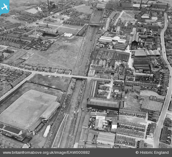
EAW000882 ENGLAND (1946). Gerrard & Sons Ltd Works, the Station Road Rugby Stadium and environs, Swinton, 1946
© Copyright OpenStreetMap contributors and licensed by the OpenStreetMap Foundation. 2026. Cartography is licensed as CC BY-SA.
Nearby Images (21)
Details
| Title | [EAW000882] Gerrard & Sons Ltd Works, the Station Road Rugby Stadium and environs, Swinton, 1946 |
| Reference | EAW000882 |
| Date | 3-June-1946 |
| Link | |
| Place name | SWINTON |
| Parish | |
| District | |
| Country | ENGLAND |
| Easting / Northing | 378034, 401964 |
| Longitude / Latitude | -2.331288706503, 53.513648279351 |
| National Grid Reference | SD780020 |
Pins

redmist |
Thursday 11th of November 2021 11:07:49 PM | |

redmist |
Thursday 11th of November 2021 11:06:44 PM | |

Lorrainepumpkin |
Thursday 11th of September 2014 12:11:06 AM | |

Lorrainepumpkin |
Thursday 11th of September 2014 12:05:31 AM | |

Lorrainepumpkin |
Wednesday 10th of September 2014 11:52:40 PM | |

Andy_S |
Monday 26th of May 2014 08:18:41 PM | |

Maitland |
Saturday 18th of January 2014 10:14:58 PM |


![[EAW000882] Gerrard & Sons Ltd Works, the Station Road Rugby Stadium and environs, Swinton, 1946](http://britainfromabove.org.uk/sites/all/libraries/aerofilms-images/public/100x100/EAW/000/EAW000882.jpg)
![[EAW032719] The J. Gerrard and Sons Ltd Works off Pendlebury Road and Station Road Rugby Ground (Swinton Lions), Swinton, 1950. This image was marked by Aerofilms Ltd for photo editing.](http://britainfromabove.org.uk/sites/all/libraries/aerofilms-images/public/100x100/EAW/032/EAW032719.jpg)
![[EAW000887] Gerrard & Sons Ltd Works and environs, Swinton, 1946](http://britainfromabove.org.uk/sites/all/libraries/aerofilms-images/public/100x100/EAW/000/EAW000887.jpg)
![[EAW032717] The J. Gerrard and Sons Ltd Works off Pendlebury Road, Swinton, 1950. This image was marked by Aerofilms Ltd for photo editing.](http://britainfromabove.org.uk/sites/all/libraries/aerofilms-images/public/100x100/EAW/032/EAW032717.jpg)
![[EAW032720] The J. Gerrard and Sons Ltd Works off Pendlebury Road and Station Road Rugby Ground (Swinton Lions), Swinton, 1950. This image was marked by Aerofilms Ltd for photo editing.](http://britainfromabove.org.uk/sites/all/libraries/aerofilms-images/public/100x100/EAW/032/EAW032720.jpg)
![[EAW000880] Gerrard & Sons Ltd Works, the Station Road Rugby Stadium and environs, Swinton, 1946](http://britainfromabove.org.uk/sites/all/libraries/aerofilms-images/public/100x100/EAW/000/EAW000880.jpg)
![[EAW032725] The J. Gerrard and Sons Ltd Works off Pendlebury Road and Station Road Rugby Ground (Swinton Lions), Swinton, 1950. This image was marked by Aerofilms Ltd for photo editing.](http://britainfromabove.org.uk/sites/all/libraries/aerofilms-images/public/100x100/EAW/032/EAW032725.jpg)
![[EAW032726] The J. Gerrard and Sons Ltd Works off Pendlebury Road, Swinton, 1950. This image was marked by Aerofilms Ltd for photo editing.](http://britainfromabove.org.uk/sites/all/libraries/aerofilms-images/public/100x100/EAW/032/EAW032726.jpg)
![[EAW032724] The J. Gerrard and Sons Ltd Works off Pendlebury Road and Station Road Rugby Ground (Swinton Lions), Swinton, 1950. This image was marked by Aerofilms Ltd for photo editing.](http://britainfromabove.org.uk/sites/all/libraries/aerofilms-images/public/100x100/EAW/032/EAW032724.jpg)
![[EAW000884] Gerrard & Sons Ltd Works, Swinton, from the north, 1946](http://britainfromabove.org.uk/sites/all/libraries/aerofilms-images/public/100x100/EAW/000/EAW000884.jpg)
![[EAW032723] The J. Gerrard and Sons Ltd Works off Pendlebury Road, Swinton, 1950. This image was marked by Aerofilms Ltd for photo editing.](http://britainfromabove.org.uk/sites/all/libraries/aerofilms-images/public/100x100/EAW/032/EAW032723.jpg)
![[EAW032727] The J. Gerrard and Sons Ltd Works off Pendlebury Road, Swinton, 1950. This image was marked by Aerofilms Ltd for photo editing.](http://britainfromabove.org.uk/sites/all/libraries/aerofilms-images/public/100x100/EAW/032/EAW032727.jpg)
![[EPW018859] Gerrard's Works, Swinton, 1927](http://britainfromabove.org.uk/sites/all/libraries/aerofilms-images/public/100x100/EPW/018/EPW018859.jpg)
![[EAW032721] The J. Gerrard and Sons Ltd Works off Pendlebury Road and Station Road Rugby Ground (Swinton Lions), Swinton, 1950. This image was marked by Aerofilms Ltd for photo editing.](http://britainfromabove.org.uk/sites/all/libraries/aerofilms-images/public/100x100/EAW/032/EAW032721.jpg)
![[EAW032718] The J. Gerrard and Sons Ltd Works off Pendlebury Road, Swinton, 1950. This image was marked by Aerofilms Ltd for photo editing.](http://britainfromabove.org.uk/sites/all/libraries/aerofilms-images/public/100x100/EAW/032/EAW032718.jpg)
![[EPW018860] Gerrard's Works and Hope Cotton Mill, Swinton, 1927](http://britainfromabove.org.uk/sites/all/libraries/aerofilms-images/public/100x100/EPW/018/EPW018860.jpg)
![[EAW000885] Gerrard & Sons Ltd Works, Swinton, 1946](http://britainfromabove.org.uk/sites/all/libraries/aerofilms-images/public/100x100/EAW/000/EAW000885.jpg)
![[EAW000888] Gerrard & Sons Ltd Works and environs, Swinton, 1946](http://britainfromabove.org.uk/sites/all/libraries/aerofilms-images/public/100x100/EAW/000/EAW000888.jpg)
![[EAW000883] Gerrard & Sons Ltd Works, the Station Road Rugby Stadium and environs, Swinton, 1946](http://britainfromabove.org.uk/sites/all/libraries/aerofilms-images/public/100x100/EAW/000/EAW000883.jpg)
![[EAW000886] Gerrard & Sons Ltd Works and environs, Swinton, 1946](http://britainfromabove.org.uk/sites/all/libraries/aerofilms-images/public/100x100/EAW/000/EAW000886.jpg)
![[EAW032722] The J. Gerrard and Sons Ltd Works off Pendlebury Road and Station Road Rugby Ground (Swinton Lions), Swinton, 1950. This image was marked by Aerofilms Ltd for photo editing.](http://britainfromabove.org.uk/sites/all/libraries/aerofilms-images/public/100x100/EAW/032/EAW032722.jpg)