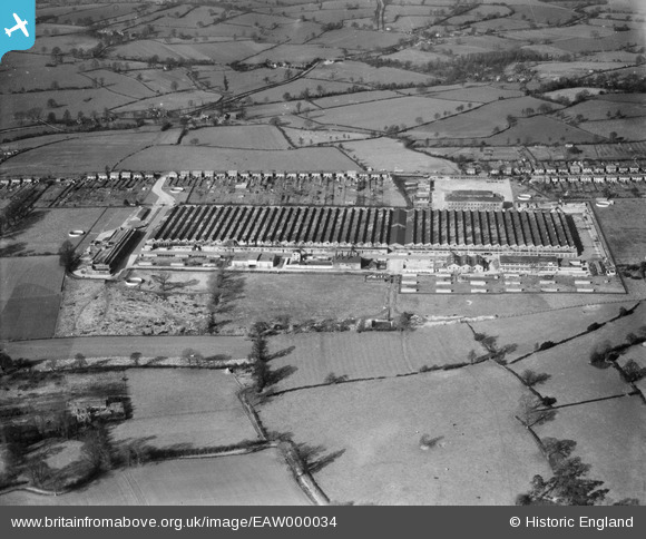
EAW000034 ENGLAND (1946). The Daimler Motor Company Ltd shadow factory at Browns Lane, Coventry, 1946
© Copyright OpenStreetMap contributors and licensed by the OpenStreetMap Foundation. 2024. Cartography is licensed as CC BY-SA.
Nearby Images (11)
Details
| Title | [EAW000034] The Daimler Motor Company Ltd shadow factory at Browns Lane, Coventry, 1946 |
| Reference | EAW000034 |
| Date | 24-January-1946 |
| Link | |
| Place name | COVENTRY |
| Parish | |
| District | |
| Country | ENGLAND |
| Easting / Northing | 430033, 281772 |
| Longitude / Latitude | -1.5582078240958, 52.432724993908 |
| National Grid Reference | SP300818 |
Pins
 redmist |
Thursday 27th of October 2022 08:28:40 PM | |
 redmist |
Thursday 27th of October 2022 08:28:10 PM | |
 redmist |
Thursday 27th of October 2022 08:27:25 PM | |
 Sparky |
Saturday 5th of August 2017 10:46:20 PM | |
 Sparky |
Saturday 5th of August 2017 10:45:40 PM | |
 Sparky |
Saturday 5th of August 2017 10:45:00 PM | |
 Sparky |
Saturday 5th of August 2017 10:44:36 PM | |
 Sparky |
Saturday 5th of August 2017 10:44:03 PM | |
 JG |
Monday 9th of September 2013 04:53:40 PM | |
 JG |
Monday 9th of September 2013 04:53:23 PM |


![[EAW000034] The Daimler Motor Company Ltd shadow factory at Browns Lane, Coventry, 1946](http://britainfromabove.org.uk/sites/all/libraries/aerofilms-images/public/100x100/EAW/000/EAW000034.jpg)
![[EAW000030] The Daimler Motor Company Ltd shadow factory at Browns Lane, Coventry, 1946](http://britainfromabove.org.uk/sites/all/libraries/aerofilms-images/public/100x100/EAW/000/EAW000030.jpg)
![[EAW000126] Browns Lane Motor Works, Allesley, 1946](http://britainfromabove.org.uk/sites/all/libraries/aerofilms-images/public/100x100/EAW/000/EAW000126.jpg)
![[EAW000127] Browns Lane Motor Works, Allesley, 1946](http://britainfromabove.org.uk/sites/all/libraries/aerofilms-images/public/100x100/EAW/000/EAW000127.jpg)
![[EAW000033] The Daimler Motor Company Ltd shadow factory at Browns Lane, Coventry, 1946](http://britainfromabove.org.uk/sites/all/libraries/aerofilms-images/public/100x100/EAW/000/EAW000033.jpg)
![[EAW000032] The Daimler Motor Company Ltd shadow factory at Browns Lane, Coventry, 1946](http://britainfromabove.org.uk/sites/all/libraries/aerofilms-images/public/100x100/EAW/000/EAW000032.jpg)
![[EAW000031] The Daimler Motor Company Ltd shadow factory at Browns Lane, Coventry, 1946](http://britainfromabove.org.uk/sites/all/libraries/aerofilms-images/public/100x100/EAW/000/EAW000031.jpg)
![[EAW000129] Browns Lane Motor Works, Allesley, 1946](http://britainfromabove.org.uk/sites/all/libraries/aerofilms-images/public/100x100/EAW/000/EAW000129.jpg)
![[EAW000029] The Daimler Motor Company Ltd shadow factory at Browns Lane, Coventry, 1946](http://britainfromabove.org.uk/sites/all/libraries/aerofilms-images/public/100x100/EAW/000/EAW000029.jpg)
![[EAW000130] Browns Lane Motor Works, Allesley, 1946](http://britainfromabove.org.uk/sites/all/libraries/aerofilms-images/public/100x100/EAW/000/EAW000130.jpg)
![[EAW000132] Browns Lane Motor Works and environs, Allesley, 1946](http://britainfromabove.org.uk/sites/all/libraries/aerofilms-images/public/100x100/EAW/000/EAW000132.jpg)