
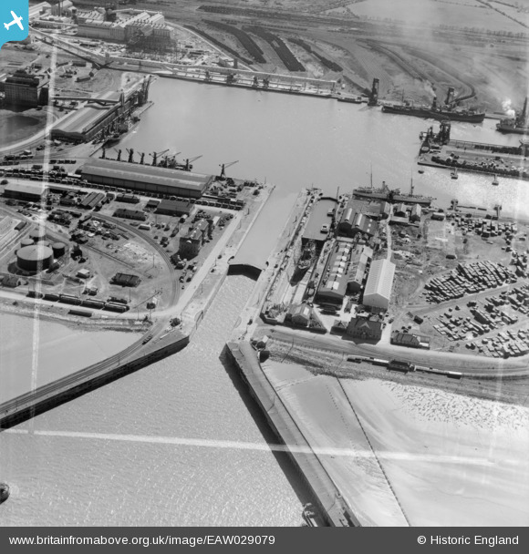
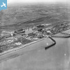
eaw029079 ENGLAND (1950). Immingham Dock, Immingham, 1950. This image was marked by Aerofilms Ltd for photo editing.
© Copyright OpenStreetMap contributors and licensed by the OpenStreetMap Foundation. 2025. Cartography is licensed as CC BY-SA.
Nearby Images (20)
EAW029079

EAW030250

EAW029082
EAW030252

EAW029081

EAW030253

EAW030242

EAW030251

EAW030244
EAW029089

EAW029083
EAW029091

EAW030247

EPW006532
EAW029084

EAW030241

EAW029088

EAW030243

EAW029085

EAW030249

Details
| Title | [EAW029079] Immingham Dock, Immingham, 1950. This image was marked by Aerofilms Ltd for photo editing. |
| Reference | EAW029079 |
| Date | 10-May-1950 |
| Link | |
| Place name | IMMINGHAM |
| Parish | IMMINGHAM |
| District | |
| Country | ENGLAND |
| Easting / Northing | 519845, 416330 |
| Longitude / Latitude | -0.18747667394006, 53.629525447964 |
| National Grid Reference | TA198163 |
Pins
 DaveH |
Monday 5th of October 2020 02:24:59 PM | |
Sparky |
Sunday 22nd of October 2017 10:50:45 PM | |
Sparky |
Sunday 22nd of October 2017 10:50:14 PM | |
DaveH |
Sunday 18th of September 2016 11:55:24 PM | |
DaveH |
Sunday 18th of September 2016 11:51:36 PM | |
DaveH |
Sunday 18th of September 2016 11:49:56 PM | |
DaveH |
Sunday 18th of September 2016 11:48:33 PM | |
DaveH |
Sunday 18th of September 2016 11:45:45 PM | |
 Class31 |
Monday 31st of March 2014 04:52:02 PM |