
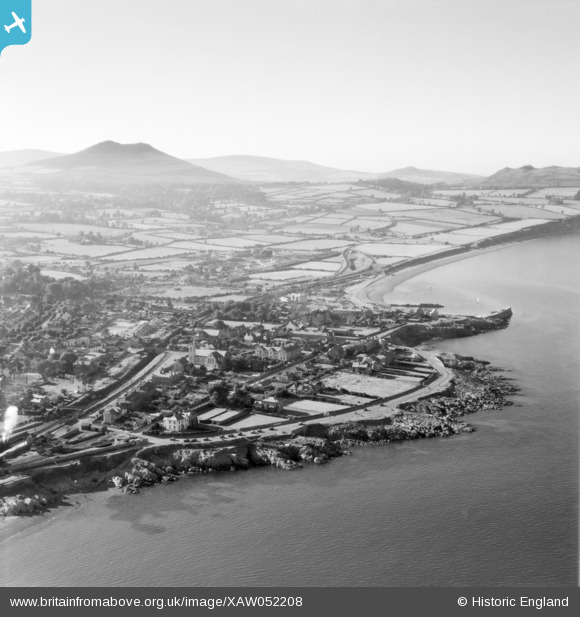
XAW052208 IRELAND (1953). Greystones Spec, Graystones, Wicklow, Ireland, 1953. Oblique aerial photograph taken facing North/West.
© Copyright OpenStreetMap contributors and licensed by the OpenStreetMap Foundation. 2024. Cartography is licensed as CC BY-SA.
Nearby Images (2)
XAW052208

XAW052209

Details
| Title | [XAW052208] Greystones Spec, Graystones, Wicklow, Ireland, 1953. Oblique aerial photograph taken facing North/West. |
| Reference | XAW052208 |
| Date | 1953 |
| Link | |
| Place name | GRAYSTONES |
| Parish | IRELAND |
| District | |
| Country | IRELAND |
| Easting / Northing | 128549, 368626 |
| Longitude / Latitude | -6.060775, 53.145429 |
| National Grid Reference |
Pins
 John Swain |
Thursday 16th of October 2014 10:38:27 AM | |
This is not the Little Sugar Loaf. It is an area near Windgates on the Bray Greystones road. |
 Aidan |
Sunday 23rd of November 2014 12:49:18 PM |
John Swain |
Thursday 16th of October 2014 10:37:45 AM | |
This is in fact the Little Sugar Loaf. The Sugarloaf,not visible in this photo, is to the left of this hill. |
Aidan |
Sunday 23rd of November 2014 12:51:11 PM |
John Swain |
Thursday 16th of October 2014 10:33:28 AM | |
John Swain |
Thursday 16th of October 2014 10:27:25 AM | |
John Swain |
Thursday 16th of October 2014 10:26:10 AM | |
John Swain |
Thursday 16th of October 2014 10:06:39 AM | |
John Swain |
Thursday 16th of October 2014 10:03:39 AM | |
John Swain |
Thursday 16th of October 2014 10:01:29 AM | |
John Swain |
Thursday 16th of October 2014 09:59:03 AM | |
John Swain |
Thursday 16th of October 2014 09:51:11 AM | |
John Swain |
Thursday 16th of October 2014 09:50:21 AM | |
John Swain |
Thursday 16th of October 2014 09:45:38 AM | |
John Swain |
Thursday 16th of October 2014 09:44:22 AM |
User Comment Contributions
Greystones is a seaside resort on the Wicklow-Bray Road, which had a population of 1,530 in 1936 and had grown from a tiny fishing hamlet into a residential centre, along with its close neighbour of Delgany, of 3,600 by 1956. The town has been described as a holiday and residential centre of infinite respectability, with tree-lined roads, substantial houses, spacious gardens and a pleasant lack of uniformity. The residential population has more than doubled over the last 50 years and the town is now an important commuter town, with excellent road and rail links to the capital, which include the recent extension of the Dublin Area Rapid Transit System from Bray to Greystones. The area is also a popular choice for retired folk, including ex-pats from the UK. |
John Swain |
Thursday 16th of October 2014 10:23:40 AM |


