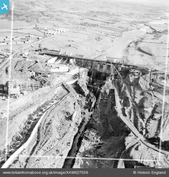
XAW027556 IRELAND (1949). Cementation Co. Works, Ballyshannon, Donegal, Ireland, 1949. Oblique aerial photograph taken facing East. This image was marked by Aerofilms Ltd for photo editing.
© Copyright OpenStreetMap contributors and licensed by the OpenStreetMap Foundation. 2024. Cartography is licensed as CC BY-SA.
Nearby Images (37)
Details
| Title | [XAW027556] Cementation Co. Works, Ballyshannon, Donegal, Ireland, 1949. Oblique aerial photograph taken facing East. This image was marked by Aerofilms Ltd for photo editing. |
| Reference | XAW027556 |
| Date | 2-November-1949 |
| Link | |
| Place name | BALLYSHANNON |
| Parish | IRELAND |
| District | |
| Country | IRELAND |
| Easting / Northing | 352, 529185 |
| Longitude / Latitude | -8.176272, 54.499866 |
| National Grid Reference |
Pins
Be the first to add a comment to this image!


![[XAW027556] Cementation Co. Works, Ballyshannon, Donegal, Ireland, 1949. Oblique aerial photograph taken facing East. This image was marked by Aerofilms Ltd for photo editing.](http://britainfromabove.org.uk/sites/all/libraries/aerofilms-images/public/100x100/XAW/027/XAW027556.jpg)
![[XAW027557] Cementation Co. Works, Ballyshannon, Donegal, Ireland, 1949. Oblique aerial photograph taken facing South/East. This image was marked by Aerofilms Ltd for photo editing.](http://britainfromabove.org.uk/sites/all/libraries/aerofilms-images/public/100x100/XAW/027/XAW027557.jpg)
![[XAW019070] Cementation Co. Works, Ballyshannon, Donegal, Ireland, 1948. Oblique aerial photograph taken facing West.](http://britainfromabove.org.uk/sites/all/libraries/aerofilms-images/public/100x100/XAW/019/XAW019070.jpg)
![[XAW009867] Cementation Co. Works, Ballyshannon, Donegal, Ireland, 1947. Oblique aerial photograph taken facing North/West.](http://britainfromabove.org.uk/sites/all/libraries/aerofilms-images/public/100x100/XAW/009/XAW009867.jpg)
![[XAW019041] Cementation Co. Works, Ballyshannon, Donegal, Ireland, 1948. Oblique aerial photograph taken facing South.](http://britainfromabove.org.uk/sites/all/libraries/aerofilms-images/public/100x100/XAW/019/XAW019041.jpg)
![[XAW027542] Cementation Co. Works, Ballyshannon, Donegal, Ireland, 1949. Oblique aerial photograph taken facing East. This image was marked by Aerofilms Ltd for photo editing.](http://britainfromabove.org.uk/sites/all/libraries/aerofilms-images/public/100x100/XAW/027/XAW027542.jpg)
![[XAW019086] Cementation Co. Works, Ballyshannon, Donegal, Ireland, 1948. Oblique aerial photograph taken facing West.](http://britainfromabove.org.uk/sites/all/libraries/aerofilms-images/public/100x100/XAW/019/XAW019086.jpg)
![[XAW009855] Cementation Co. Works, Ballyshannon, Donegal, Ireland, 1947. Oblique aerial photograph taken facing North/East.](http://britainfromabove.org.uk/sites/all/libraries/aerofilms-images/public/100x100/XAW/009/XAW009855.jpg)
![[XAW027549] Cementation Co. Works, Ballyshannon, Donegal, Ireland, 1949. Oblique aerial photograph taken facing South. This image was marked by Aerofilms Ltd for photo editing.](http://britainfromabove.org.uk/sites/all/libraries/aerofilms-images/public/100x100/XAW/027/XAW027549.jpg)
![[XAW027548] Cementation Co. Works, Ballyshannon, Donegal, Ireland, 1949. Oblique aerial photograph taken facing East. This image was marked by Aerofilms Ltd for photo editing.](http://britainfromabove.org.uk/sites/all/libraries/aerofilms-images/public/100x100/XAW/027/XAW027548.jpg)
![[XAW027547] Cementation Co. Works, Ballyshannon, Donegal, Ireland, 1949. Oblique aerial photograph taken facing South/East. This image was marked by Aerofilms Ltd for photo editing.](http://britainfromabove.org.uk/sites/all/libraries/aerofilms-images/public/100x100/XAW/027/XAW027547.jpg)
![[XAW027554] Cementation Co. Works, Ballyshannon, Donegal, Ireland, 1949. Oblique aerial photograph taken facing East. This image was marked by Aerofilms Ltd for photo editing.](http://britainfromabove.org.uk/sites/all/libraries/aerofilms-images/public/100x100/XAW/027/XAW027554.jpg)
![[XAW009861] Cementation Co. Works, Ballyshannon, Donegal, Ireland, 1947. Oblique aerial photograph taken facing East.](http://britainfromabove.org.uk/sites/all/libraries/aerofilms-images/public/100x100/XAW/009/XAW009861.jpg)
![[XAW009857] Cementation Co. Works, Ballyshannon, Donegal, Ireland, 1947. Oblique aerial photograph taken facing North.](http://britainfromabove.org.uk/sites/all/libraries/aerofilms-images/public/100x100/XAW/009/XAW009857.jpg)
![[XAW019031] Cementation Co. Works, Ballyshannon, Donegal, Ireland, 1948. Oblique aerial photograph taken facing North/East.](http://britainfromabove.org.uk/sites/all/libraries/aerofilms-images/public/100x100/XAW/019/XAW019031.jpg)
![[XAW019061] Cementation Co. Works, Ballyshannon, Donegal, Ireland, 1948. Oblique aerial photograph taken facing North/West.](http://britainfromabove.org.uk/sites/all/libraries/aerofilms-images/public/100x100/XAW/019/XAW019061.jpg)
![[XAW009862] Cementation Co. Works, Ballyshannon, Donegal, Ireland, 1947. Oblique aerial photograph taken facing North/East.](http://britainfromabove.org.uk/sites/all/libraries/aerofilms-images/public/100x100/XAW/009/XAW009862.jpg)
![[XAW027551] Cementation Co. Works, Ballyshannon, Donegal, Ireland, 1949. Oblique aerial photograph taken facing South/East. This image was marked by Aerofilms Ltd for photo editing.](http://britainfromabove.org.uk/sites/all/libraries/aerofilms-images/public/100x100/XAW/027/XAW027551.jpg)
![[XAW009856] Cementation Co. Works, Ballyshannon, Donegal, Ireland, 1947. Oblique aerial photograph taken facing South/West.](http://britainfromabove.org.uk/sites/all/libraries/aerofilms-images/public/100x100/XAW/009/XAW009856.jpg)
![[XAW019084] Cementation Co. Works, Ballyshannon, Donegal, Ireland, 1948. Oblique aerial photograph taken facing North/East.](http://britainfromabove.org.uk/sites/all/libraries/aerofilms-images/public/100x100/XAW/019/XAW019084.jpg)
![[XAW019081] Cementation Co. Works, Ballyshannon, Donegal, Ireland, 1948. Oblique aerial photograph taken facing West.](http://britainfromabove.org.uk/sites/all/libraries/aerofilms-images/public/100x100/XAW/019/XAW019081.jpg)
![[XAW027555] Cementation Co. Works, Ballyshannon, Donegal, Ireland, 1949. Oblique aerial photograph taken facing North. This image was marked by Aerofilms Ltd for photo editing.](http://britainfromabove.org.uk/sites/all/libraries/aerofilms-images/public/100x100/XAW/027/XAW027555.jpg)
![[XAW019069] Cementation Co. Works, Ballyshannon, Donegal, Ireland, 1948. Oblique aerial photograph taken facing North/East.](http://britainfromabove.org.uk/sites/all/libraries/aerofilms-images/public/100x100/XAW/019/XAW019069.jpg)
![[XAW019042] Cementation Co. Works, Ballyshannon, Donegal, Ireland, 1948. Oblique aerial photograph taken facing South.](http://britainfromabove.org.uk/sites/all/libraries/aerofilms-images/public/100x100/XAW/019/XAW019042.jpg)
![[XAW019051] Cementation Co. Works, Ballyshannon, Donegal, Ireland, 1948. Oblique aerial photograph taken facing North.](http://britainfromabove.org.uk/sites/all/libraries/aerofilms-images/public/100x100/XAW/019/XAW019051.jpg)
![[XAW027543] Cementation Co. Works, Ballyshannon, Donegal, Ireland, 1949. Oblique aerial photograph taken facing North. This image was marked by Aerofilms Ltd for photo editing.](http://britainfromabove.org.uk/sites/all/libraries/aerofilms-images/public/100x100/XAW/027/XAW027543.jpg)
![[XAW009863] Cementation Co. Works, Ballyshannon, Donegal, Ireland, 1947. Oblique aerial photograph taken facing East.](http://britainfromabove.org.uk/sites/all/libraries/aerofilms-images/public/100x100/XAW/009/XAW009863.jpg)
![[XAW019071] Cementation Co. Works, Ballyshannon, Donegal, Ireland, 1948. Oblique aerial photograph taken facing East.](http://britainfromabove.org.uk/sites/all/libraries/aerofilms-images/public/100x100/XAW/019/XAW019071.jpg)
![[XAW019062] Cementation Co. Works, Ballyshannon, Donegal, Ireland, 1948. Oblique aerial photograph taken facing West.](http://britainfromabove.org.uk/sites/all/libraries/aerofilms-images/public/100x100/XAW/019/XAW019062.jpg)
![[XAW019088] Cementation Co. Works, Ballyshannon, Donegal, Ireland, 1948. Oblique aerial photograph taken facing East.](http://britainfromabove.org.uk/sites/all/libraries/aerofilms-images/public/100x100/XAW/019/XAW019088.jpg)
![[XAW027558] Cementation Co. Works, Ballyshannon, Donegal, Ireland, 1949. Oblique aerial photograph taken facing Nort/West. This image was marked by Aerofilms Ltd for photo editing.](http://britainfromabove.org.uk/sites/all/libraries/aerofilms-images/public/100x100/XAW/027/XAW027558.jpg)
![[XAW019059] Cementation Co. Works, Ballyshannon, Donegal, Ireland, 1948. Oblique aerial photograph taken facing West.](http://britainfromabove.org.uk/sites/all/libraries/aerofilms-images/public/100x100/XAW/019/XAW019059.jpg)
![[XAW027545] Cementation Co. Works, Ballyshannon, Donegal, Ireland, 1949. Oblique aerial photograph taken facing West. This image was marked by Aerofilms Ltd for photo editing.](http://britainfromabove.org.uk/sites/all/libraries/aerofilms-images/public/100x100/XAW/027/XAW027545.jpg)
![[XAW027540] Cementation Co. Works, Ballyshannon, Donegal, Ireland, 1949. Oblique aerial photograph taken facing North/East. This image was marked by Aerofilms Ltd for photo editing.](http://britainfromabove.org.uk/sites/all/libraries/aerofilms-images/public/100x100/XAW/027/XAW027540.jpg)
![[XAW027546] Cementation Co. Works, Ballyshannon, Donegal, Ireland, 1949. Oblique aerial photograph taken facing West. This image was marked by Aerofilms Ltd for photo editing.](http://britainfromabove.org.uk/sites/all/libraries/aerofilms-images/public/100x100/XAW/027/XAW027546.jpg)
![[XAW019064] Cementation Co. Works, Ballyshannon, Donegal, Ireland, 1948. Oblique aerial photograph taken facing West. This image has been produced from a damaged negative.](http://britainfromabove.org.uk/sites/all/libraries/aerofilms-images/public/100x100/XAW/019/XAW019064.jpg)
![[XAW027544] Cementation Co. Works, Ballyshannon, Donegal, Ireland, 1949. Oblique aerial photograph taken facing North. This image was marked by Aerofilms Ltd for photo editing.](http://britainfromabove.org.uk/sites/all/libraries/aerofilms-images/public/100x100/XAW/027/XAW027544.jpg)