
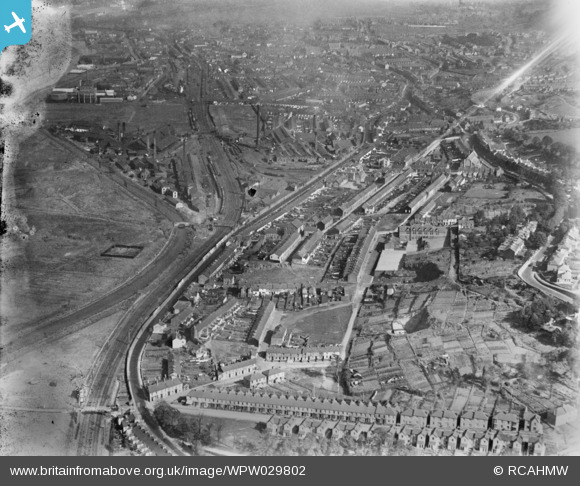
WPW029802 WALES (1929). View of Neath, oblique aerial view. 5"x4" black and white glass plate negative.
© Copyright OpenStreetMap contributors and licensed by the OpenStreetMap Foundation. 2024. Cartography is licensed as CC BY-SA.
Nearby Images (5)
WPW029799

WPW029802

WPW029804

WPW029805

WPW029807

Details
| Title | [WPW029802] View of Neath, oblique aerial view. 5"x4" black and white glass plate negative. |
| Reference | WPW029802 |
| Date | 1929 |
| Link | Coflein Archive Item 6370651 |
| Place name | |
| Parish | |
| District | |
| Country | WALES |
| Easting / Northing | 274000, 197000 |
| Longitude / Latitude | -3.8217466213702, 51.657179567368 |
| National Grid Reference | SS740970 |
Pins
 jacobbayliss |
Sunday 24th of December 2023 02:23:53 PM | |
Mick |
Monday 6th of February 2017 04:25:27 AM | |
Mick |
Monday 6th of February 2017 04:24:17 AM | |
Mick |
Monday 6th of February 2017 04:24:14 AM | |
gBr |
Wednesday 7th of January 2015 04:46:36 PM | |
 Class31 |
Monday 28th of October 2013 12:33:51 PM | |
Class31 |
Monday 28th of October 2013 12:30:03 PM | |
sloyne |
Sunday 28th of July 2013 11:03:30 PM | |
Yes. Remember the signal box and Neath Shed as a lad. Lived in 5 Pant Yr Heol (3 Raymond Terrace before they renamed it). |
Mick |
Monday 6th of February 2017 04:48:37 AM |
sloyne |
Sunday 28th of July 2013 10:59:11 PM | |
sloyne |
Sunday 28th of July 2013 10:56:51 PM | |
sloyne |
Sunday 28th of July 2013 10:56:08 PM | |
sloyne |
Sunday 28th of July 2013 10:55:05 PM | |
sloyne |
Sunday 28th of July 2013 10:54:08 PM | |
Nowy Paul |
Sunday 11th of November 2012 02:39:05 PM | |
BRIAN TAYLOR |
Tuesday 10th of July 2012 02:06:34 PM | |
Class31 |
Monday 2nd of July 2012 10:04:11 AM | |
Class31 |
Monday 2nd of July 2012 10:03:07 AM | |
old road not oak |
BRIAN TAYLOR |
Tuesday 10th of July 2012 02:04:33 PM |
Class31 |
Monday 2nd of July 2012 10:02:22 AM |


User Comment Contributions
 'the factory' at the entrance to eaglesbush valley..it was a wool mill in victorian times.the disused tramway which led from the canal 'port' & later,a railway siding,down by mile end up behind the housing,to the Iron Foundry,Cambrian brickworks & the disused workings of Eaglesbush colliery.the tramway shows up as a white line,curving off at its end at the rear of Old road housing,it then crossed the old turnpike road & up the 'valley',past 'the Factory' & on... |
greg |
Saturday 19th of April 2014 12:35:14 PM |
 Briton Ferry Road A474 looking north east, from the railway foot bridge, 25/10/2013. |
Class31 |
Monday 28th of October 2013 12:38:06 PM |
For accuracy sake and to help orientate where this was taken the pin on the OS map accompanying the photograph should be moved down to where the letter Ppg stn appear above the name Penrhiwtyn. |
Nowy Paul |
Sunday 11th of November 2012 02:37:42 PM |