
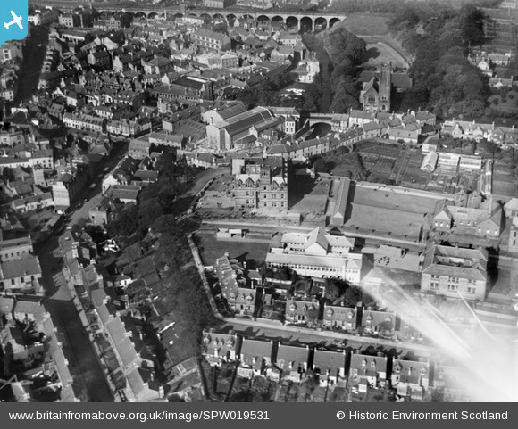
SPW019531 SCOTLAND (1927). Kilmarnock, general view, showing Kilmarnock Academy. An oblique aerial photograph taken facing north.
© Copyright OpenStreetMap contributors and licensed by the OpenStreetMap Foundation. 2024. Cartography is licensed as CC BY-SA.
Nearby Images (8)
SPW019531

SAW035407

SAR008685

SAR008686

SAR008688

SAR018742

SAR022908

SAR022909

Details
| Title | [SPW019531] Kilmarnock, general view, showing Kilmarnock Academy. An oblique aerial photograph taken facing north. |
| Reference | SPW019531 |
| Date | 1927 |
| Link | Canmore Collection item 1246298 |
| Place name | |
| Parish | KILMARNOCK |
| District | KILMARNOCK AND LOUDOUN |
| Country | SCOTLAND |
| Easting / Northing | 243042, 637820 |
| Longitude / Latitude | -4.4920563310982, 55.608628190751 |
| National Grid Reference | NS430378 |
Pins
 tall guy |
Saturday 16th of August 2014 07:01:49 PM | |
Killiekosmos |
Friday 23rd of August 2013 04:34:17 PM | |
docken56 |
Monday 3rd of June 2013 10:25:51 PM | |
Tritium |
Saturday 6th of April 2013 06:13:21 PM | |
Tritium |
Saturday 6th of April 2013 06:08:15 PM | |
Burned down on 20 August 2013 |
Killiekosmos |
Friday 23rd of August 2013 04:32:22 PM |
Tritium |
Saturday 6th of April 2013 06:06:51 PM |
User Comment Contributions
Sir Alexander Fleming who discovered penicillin went to school here before joining his older brother (already a Glasgow qualified doctor) in London. Alexander qualified at St Mary's Hospital, London. |
rettendon6 |
Monday 29th of July 2013 04:13:33 PM |