
SPW019507 SCOTLAND (1927). Skelmorlie, general view. An oblique aerial photograph taken facing north-east.

© Copyright OpenStreetMap contributors and licensed by the OpenStreetMap Foundation. 2024. Cartography is licensed as CC BY-SA.
Nearby Images (2)
SAR018806

SPW019507

Details
| Title | [SPW019507] Skelmorlie, general view. An oblique aerial photograph taken facing north-east. |
| Reference | SPW019507 |
| Date | 1927 |
| Link | Canmore Collection item 1246283 |
| Place name | |
| Parish | LARGS |
| District | CUNNINGHAME |
| Country | SCOTLAND |
| Easting / Northing | 219230, 667570 |
| Longitude / Latitude | -4.8892985109037, 55.867369398991 |
| National Grid Reference | NS192676 |
Pins
 |
 ewnmcg |
Wednesday 23rd of January 2013 11:12:24 AM |
thomasmann |
Wednesday 24th of October 2012 05:26:21 PM | |
thomasmann |
Wednesday 24th of October 2012 05:24:38 PM |
User Comment Contributions
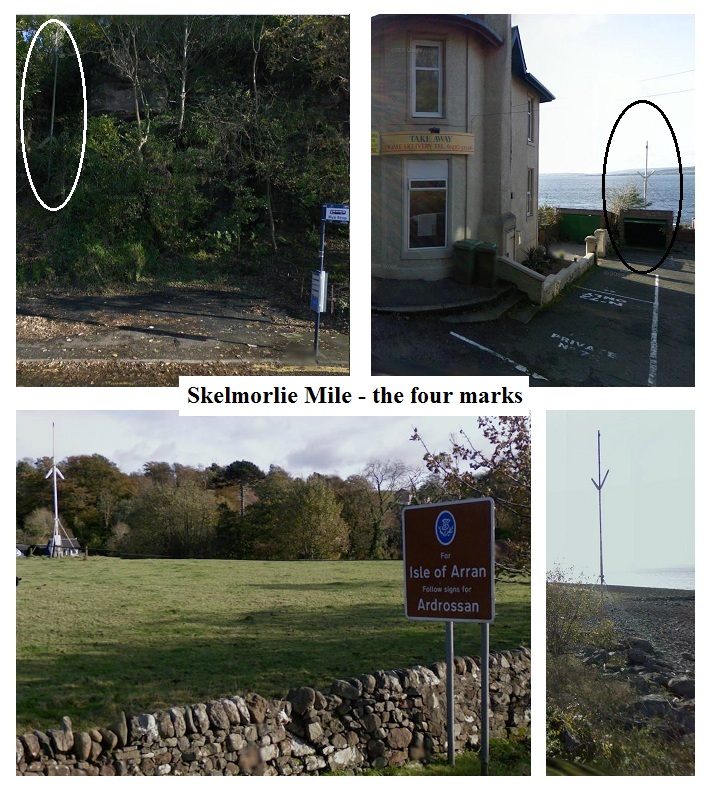 Slightly below dead-centre of the photo and close to the water's edge is a thin white pole with a 'V' on it. This is the seaward mark of the northern end of the Skelmorlie measure mile - for ships on speed trials. I was on this mile many times as a naval architect. The tip of the landward pole, which has an inverted 'V', is just visible in the trees. Both the northern and southern sets of poles are, I believe, falling into disuse due to global positioning satellites. |
ewnmcg |
Wednesday 13th of November 2013 10:07:13 AM |
Thank you for posting these images of the Skelmorlie measured mile markers. I've been doing some research on the measured miles of the North East Coast of England. They were in chronological order, the Whitley, Hartley and Newbiggin miles. All other regions of the country envied the deep water and shelter the Skelmorlie mile provided for the shipbuilders of the Clyde! |
IanW |
Wednesday 13th of November 2013 10:07:13 AM |


