
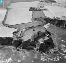
SAW046300 SCOTLAND (1952). Tantallon Castle, North Berwick. An oblique aerial photograph taken facing west.

© Copyright OpenStreetMap contributors and licensed by the OpenStreetMap Foundation. 2025. Cartography is licensed as CC BY-SA.
Nearby Images (4)
SAW046299

SAW046300

SPW027373

SAW052507

Details
| Title | [SAW046300] Tantallon Castle, North Berwick. An oblique aerial photograph taken facing west. |
| Reference | SAW046300 |
| Date | 1952 |
| Link | Canmore Collection item 1297713 |
| Place name | |
| Parish | NORTH BERWICK |
| District | EAST LOTHIAN |
| Country | SCOTLAND |
| Easting / Northing | 359523, 685000 |
| Longitude / Latitude | -2.6500162299033, 56.056193471913 |
| National Grid Reference | NT595850 |
Pins
 JMB |
Tuesday 26th of June 2012 05:26:30 PM |
User Comment Contributions
 Admiralty Gin Head Radar Experimental Establishment |
JMB |
Tuesday 21st of April 2015 08:15:35 PM |
The impressive ruins and setting of Tantallon castle. |
 Brian Wilkinson |
Friday 22nd of June 2012 12:52:52 PM |