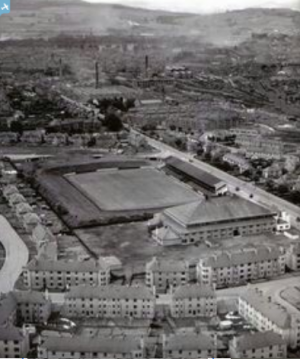
SAW026584 SCOTLAND (1949). Perth, general view, showing north Inch and Dunkeld Road, Perth, Perth, Perthshire, Scotland, 1949. An oblique aerial photograph taken facing south-east.
© Copyright OpenStreetMap contributors and licensed by the OpenStreetMap Foundation. 2024. Cartography is licensed as CC BY-SA.
Nearby Images (18)
Details
| Title | [SAW026584] Perth, general view, showing north Inch and Dunkeld Road, Perth, Perth, Perthshire, Scotland, 1949. An oblique aerial photograph taken facing south-east. |
| Reference | SAW026584 |
| Date | 1949 |
| Link | Canmore Collection item 1451920 |
| Place name | |
| Parish | PERTH |
| District | PERTH AND KINROSS |
| Country | SCOTLAND |
| Easting / Northing | 311800, 723700 |
| Longitude / Latitude | -3.4290841097035, 56.39740799192 |
| National Grid Reference | NO118237 |
Pins
 Billy Turner |
Tuesday 5th of March 2019 04:55:58 PM |


![[SAW026584] Perth, general view, showing north Inch and Dunkeld Road, Perth, Perth, Perthshire, Scotland, 1949. An oblique aerial photograph taken facing south-east.](http://britainfromabove.org.uk/sites/all/libraries/aerofilms-images/public/100x100/SAW/026/SAW026584.jpg)
![[SPW020122] Perth, general view, showing High Street and St John's Square. An oblique aerial photograph taken facing north.](http://britainfromabove.org.uk/sites/all/libraries/aerofilms-images/public/100x100/SPW/020/SPW020122.jpg)
![[SPW020089] J Pullar and Sons Ltd. Dye Works, Kinnoull and Mill Streets, Perth. An oblique aerial photograph taken facing south-east.](http://britainfromabove.org.uk/sites/all/libraries/aerofilms-images/public/100x100/SPW/020/SPW020089.jpg)
![[SPW020090] J Pullar and Sons Ltd. Dye Works, Kinnoull and Mill Streets, Perth. An oblique aerial photograph taken facing east.](http://britainfromabove.org.uk/sites/all/libraries/aerofilms-images/public/100x100/SPW/020/SPW020090.jpg)
![[SPW020091] J Pullar and Sons Ltd. Dye Works, Kinnoull and Mill Streets, Perth. An oblique aerial photograph taken facing east.](http://britainfromabove.org.uk/sites/all/libraries/aerofilms-images/public/100x100/SPW/020/SPW020091.jpg)
![[SPW020092] J Pullar and Sons Ltd. Dye Works, Kinnoull and Mill Streets, Perth. An oblique aerial photograph taken facing north-east.](http://britainfromabove.org.uk/sites/all/libraries/aerofilms-images/public/100x100/SPW/020/SPW020092.jpg)
![[SPW020093] J Pullar and Sons Ltd. Dye Works, Kinnoull and Mill Streets, Perth. An oblique aerial photograph taken facing north.](http://britainfromabove.org.uk/sites/all/libraries/aerofilms-images/public/100x100/SPW/020/SPW020093.jpg)
![[SPW020094] J Pullar and Sons Ltd. Dye Works, Kinnoull and Mill Streets, Perth. An oblique aerial photograph taken facing east.](http://britainfromabove.org.uk/sites/all/libraries/aerofilms-images/public/100x100/SPW/020/SPW020094.jpg)
![[SPW020095] J Pullar and Sons Ltd. Dye Works, Kinnoull and Mill Streets, Perth. An oblique aerial photograph taken facing north-east.](http://britainfromabove.org.uk/sites/all/libraries/aerofilms-images/public/100x100/SPW/020/SPW020095.jpg)
![[SPW020104] J Pullar and Sons Ltd. Dye Works, Kinnoull and Mill Streets, Perth. An oblique aerial photograph taken facing north-east.](http://britainfromabove.org.uk/sites/all/libraries/aerofilms-images/public/100x100/SPW/020/SPW020104.jpg)
![[SAW010738] Perth, general view, showing King James VI Golf Course and South Inch. An oblique aerial photograph taken facing north.](http://britainfromabove.org.uk/sites/all/libraries/aerofilms-images/public/100x100/SAW/010/SAW010738.jpg)
![[SAR018932] Royal George Hotel Perth, Perthshire, Scotland. An oblique aerial photograph taken facing South/West. This image was marked by AeroPictorial Ltd for photo editing.](http://britainfromabove.org.uk/sites/all/libraries/aerofilms-images/public/100x100/SAR/018/SAR018932.jpg)
![[SAR018933] Royal George Hotel Perth, Perthshire, Scotland. An oblique aerial photograph taken facing North/West. This image was marked by AeroPictorial Ltd for photo editing.](http://britainfromabove.org.uk/sites/all/libraries/aerofilms-images/public/100x100/SAR/018/SAR018933.jpg)
![[SAR017619] General View Kinnoull, Perthshire, Scotland. An oblique aerial photograph taken facing South. This image was marked by AeroPictorial Ltd for photo editing.](http://britainfromabove.org.uk/sites/all/libraries/aerofilms-images/public/100x100/SAR/017/SAR017619.jpg)
![[SAR017620] General View Kinnoull, Perthshire, Scotland. An oblique aerial photograph taken facing North. This image was marked by AeroPictorial Ltd for photo editing.](http://britainfromabove.org.uk/sites/all/libraries/aerofilms-images/public/100x100/SAR/017/SAR017620.jpg)
![[SPW020126] Perth, general view, showing Perth Bridge, Queen's Bridge and St Matthew's Church. An oblique aerial photograph taken facing north-east.](http://britainfromabove.org.uk/sites/all/libraries/aerofilms-images/public/100x100/SPW/020/SPW020126.jpg)
![[SPW040516] Perth, general view, showing Scott Street and Victoria Street. An oblique aerial photograph taken facing north.](http://britainfromabove.org.uk/sites/all/libraries/aerofilms-images/public/100x100/SPW/040/SPW040516.jpg)
![[SPW020121] Perth, general view, showing South Street and South Methven Street. An oblique aerial photograph taken facing east.](http://britainfromabove.org.uk/sites/all/libraries/aerofilms-images/public/100x100/SPW/020/SPW020121.jpg)
