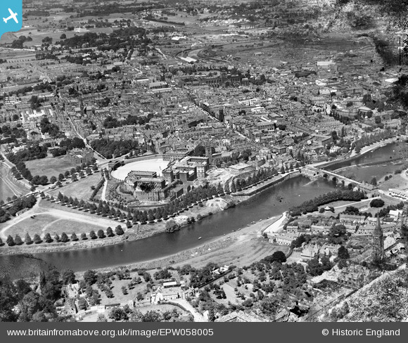
EPW058005 ENGLAND (1938). The Castle, Dee Bridge and the town, Chester, 1938. This image has been produced from a damaged negative.
© Copyright OpenStreetMap contributors and licensed by the OpenStreetMap Foundation. 2024. Cartography is licensed as CC BY-SA.
Nearby Images (15)
Details
| Title | [EPW058005] The Castle, Dee Bridge and the town, Chester, 1938. This image has been produced from a damaged negative. |
| Reference | EPW058005 |
| Date | 18-July-1938 |
| Link | |
| Place name | CHESTER |
| Parish | CHESTER CASTLE |
| District | |
| Country | ENGLAND |
| Easting / Northing | 340538, 365820 |
| Longitude / Latitude | -2.8899547605837, 53.18586028031 |
| National Grid Reference | SJ405658 |
Pins
 totoro |
Saturday 15th of June 2013 08:48:54 PM | |
 totoro |
Saturday 15th of June 2013 08:47:49 PM | |
 totoro |
Saturday 15th of June 2013 07:12:19 PM | |
 totoro |
Saturday 15th of June 2013 07:11:27 PM | |
 totoro |
Saturday 15th of June 2013 07:10:20 PM | |
 totoro |
Saturday 15th of June 2013 07:07:01 PM | |
 totoro |
Saturday 15th of June 2013 07:03:25 PM | |
 totoro |
Saturday 15th of June 2013 07:02:45 PM | |
 totoro |
Saturday 15th of June 2013 07:01:44 PM | |
 totoro |
Saturday 15th of June 2013 07:00:08 PM | |
 totoro |
Saturday 15th of June 2013 06:59:47 PM | |
 totoro |
Saturday 15th of June 2013 06:59:21 PM | |
 totoro |
Saturday 15th of June 2013 06:58:47 PM | |
 totoro |
Saturday 15th of June 2013 06:58:16 PM |
User Comment Contributions
St. Michael's Church, Bridge Street, Chester, 18/07/2015 |
 Class31 |
Friday 7th of August 2015 08:25:09 AM |


![[EPW058005] The Castle, Dee Bridge and the town, Chester, 1938. This image has been produced from a damaged negative.](http://britainfromabove.org.uk/sites/all/libraries/aerofilms-images/public/100x100/EPW/058/EPW058005.jpg)
![[EPW036916] Chester Castle and Assize Courts, Chester, 1931](http://britainfromabove.org.uk/sites/all/libraries/aerofilms-images/public/100x100/EPW/036/EPW036916.jpg)
![[EAW013773] Grosvenor Bridge, Dee Bridge and the city centre, Chester, 1948](http://britainfromabove.org.uk/sites/all/libraries/aerofilms-images/public/100x100/EAW/013/EAW013773.jpg)
![[EPW029882] Chester Castle and Assize Courts, Chester, 1929](http://britainfromabove.org.uk/sites/all/libraries/aerofilms-images/public/100x100/EPW/029/EPW029882.jpg)
![[EAW013775] Chester Castle, County Hall and St Mary on the Hill Church, Chester, 1948. This image has been produced from a damaged negative.](http://britainfromabove.org.uk/sites/all/libraries/aerofilms-images/public/100x100/EAW/013/EAW013775.jpg)
![[EPW003087] The Castle, Chester, 1920. This image has been produced from a copy-negative.](http://britainfromabove.org.uk/sites/all/libraries/aerofilms-images/public/100x100/EPW/003/EPW003087.jpg)
![[EPW003088] Lower Bridge Street and environs, Chester, 1920. This image has been produced from a copy-negative.](http://britainfromabove.org.uk/sites/all/libraries/aerofilms-images/public/100x100/EPW/003/EPW003088.jpg)
![[EPW004002] Dee Bridge and Lower Bridge Street, Chester, 1920. This image has been produced from a print.](http://britainfromabove.org.uk/sites/all/libraries/aerofilms-images/public/100x100/EPW/004/EPW004002.jpg)
![[EPW004001] Chester Castle, Chester, 1920](http://britainfromabove.org.uk/sites/all/libraries/aerofilms-images/public/100x100/EPW/004/EPW004001.jpg)
![[EPW003092] Chester Castle, Chester, 1920](http://britainfromabove.org.uk/sites/all/libraries/aerofilms-images/public/100x100/EPW/003/EPW003092.jpg)
![[EPW058008] The city, Chester, from the south-west, 1938. This image has been produced from a copy-negative.](http://britainfromabove.org.uk/sites/all/libraries/aerofilms-images/public/100x100/EPW/058/EPW058008.jpg)
![[EAW013774] Chester Castle and the city centre, Chester, 1948](http://britainfromabove.org.uk/sites/all/libraries/aerofilms-images/public/100x100/EAW/013/EAW013774.jpg)
![[EPW058012] St Mary's Church, Dee Bridge and the town, Chester, 1938](http://britainfromabove.org.uk/sites/all/libraries/aerofilms-images/public/100x100/EPW/058/EPW058012.jpg)
![[EPW058003] The River Dee and the city, Chester, 1938. This image has been produced from a print.](http://britainfromabove.org.uk/sites/all/libraries/aerofilms-images/public/100x100/EPW/058/EPW058003.jpg)
![[EPW003098] The Dee Bridge, Chester, 1920](http://britainfromabove.org.uk/sites/all/libraries/aerofilms-images/public/100x100/EPW/003/EPW003098.jpg)