
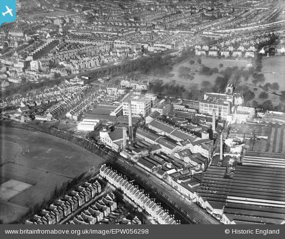
EPW056298 ENGLAND (1938). The Eastman and Son Cleaning and Dyeing Works and environs, Acton, 1938
© Copyright OpenStreetMap contributors and licensed by the OpenStreetMap Foundation. 2024. Cartography is licensed as CC BY-SA.
Nearby Images (28)
EPW056298

EPW056300

EPW056297

EPW056295

EPW056248

EPW056296

EPW056294

EPW056244

EPW056293

EPW056299

EPW056292

EPW056249

EPW056246

EPW056245

EPW056247

EPW056291

EPW044577

EPW056250

EPW006184

EPW044640

EPW010694

EPW006169

EPW044639

EPW044643

EPW007147

EPW044642

EPW044578

EPW044641

Details
| Title | [EPW056298] The Eastman and Son Cleaning and Dyeing Works and environs, Acton, 1938 |
| Reference | EPW056298 |
| Date | 19-January-1938 |
| Link | |
| Place name | ACTON |
| Parish | |
| District | |
| Country | ENGLAND |
| Easting / Northing | 520816, 179952 |
| Longitude / Latitude | -0.25903398675746, 51.505086933486 |
| National Grid Reference | TQ208800 |
Pins
 Leslie B |
Monday 29th of February 2016 08:05:34 PM | |
Leslie B |
Monday 29th of February 2016 08:05:33 PM | |
Leslie B |
Monday 29th of February 2016 08:02:39 PM | |
Leslie B |
Monday 29th of February 2016 08:00:45 PM | |
Leslie B |
Monday 29th of February 2016 07:59:42 PM |


