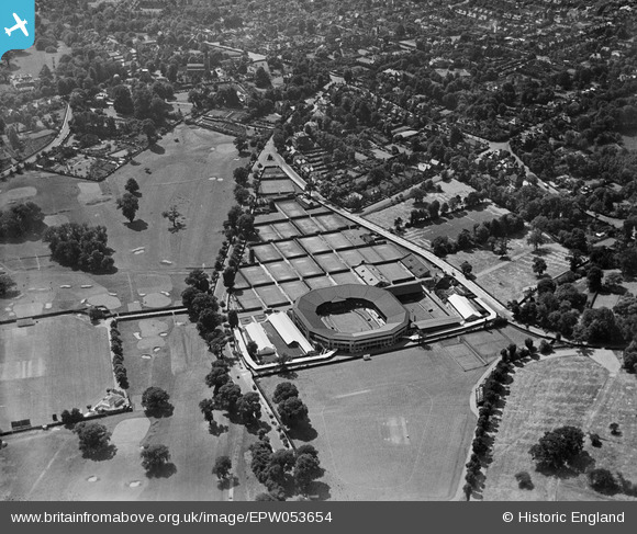
EPW053654 ENGLAND (1937). The All England Lawn Tennis and Croquet Club, Wimbledon, 1937
© Copyright OpenStreetMap contributors and licensed by the OpenStreetMap Foundation. 2024. Cartography is licensed as CC BY-SA.
Nearby Images (47)
Details
| Title | [EPW053654] The All England Lawn Tennis and Croquet Club, Wimbledon, 1937 |
| Reference | EPW053654 |
| Date | 12-June-1937 |
| Link | |
| Place name | WIMBLEDON |
| Parish | |
| District | |
| Country | ENGLAND |
| Easting / Northing | 524284, 171901 |
| Longitude / Latitude | -0.21191744160769, 51.431971037821 |
| National Grid Reference | TQ243719 |
Pins
 M.Hillier |
Monday 31st of October 2022 02:50:21 PM |
User Comment Contributions
Also Wimbledon Park Golf Club |
 Mark Rowlinson |
Wednesday 6th of November 2013 02:28:01 PM |


![[EPW053654] The All England Lawn Tennis and Croquet Club, Wimbledon, 1937](http://britainfromabove.org.uk/sites/all/libraries/aerofilms-images/public/100x100/EPW/053/EPW053654.jpg)
![[EPW016646] The All England Tennis ground, Wimbledon, 1926](http://britainfromabove.org.uk/sites/all/libraries/aerofilms-images/public/100x100/EPW/016/EPW016646.jpg)
![[EPW008875] The All England Lawn Tennis and Croquet Club, Wimbledon, 1923](http://britainfromabove.org.uk/sites/all/libraries/aerofilms-images/public/100x100/EPW/008/EPW008875.jpg)
![[EPW008876] The All England Lawn Tennis and Croquet Club, Wimbledon, 1923](http://britainfromabove.org.uk/sites/all/libraries/aerofilms-images/public/100x100/EPW/008/EPW008876.jpg)
![[EPW015874] Wimbledon, The Championships Tennis Tournament, 1926](http://britainfromabove.org.uk/sites/all/libraries/aerofilms-images/public/100x100/EPW/015/EPW015874.jpg)
![[EPW015871] Wimbledon, The Championships Tennis Tournament, 1926](http://britainfromabove.org.uk/sites/all/libraries/aerofilms-images/public/100x100/EPW/015/EPW015871.jpg)
![[EPW008525] The All England Tennis Ground, Wimbledon, 1923](http://britainfromabove.org.uk/sites/all/libraries/aerofilms-images/public/100x100/EPW/008/EPW008525.jpg)
![[EPW008526] The All England Tennis Ground, Wimbledon, 1923](http://britainfromabove.org.uk/sites/all/libraries/aerofilms-images/public/100x100/EPW/008/EPW008526.jpg)
![[EPW027613] The All England Lawn Tennis Ground, Wimbledon, 1929. This image has been produced from a copy-negative.](http://britainfromabove.org.uk/sites/all/libraries/aerofilms-images/public/100x100/EPW/027/EPW027613.jpg)
![[EPW015863] Wimbledon Tennis Championships, Wimbledon, 1926](http://britainfromabove.org.uk/sites/all/libraries/aerofilms-images/public/100x100/EPW/015/EPW015863.jpg)
![[EPW015872] Wimbledon, The Championships Tennis Tournament, 1926](http://britainfromabove.org.uk/sites/all/libraries/aerofilms-images/public/100x100/EPW/015/EPW015872.jpg)
![[EAW044357] Wimbledon, The Championships Tennis Tournament, 1952](http://britainfromabove.org.uk/sites/all/libraries/aerofilms-images/public/100x100/EAW/044/EAW044357.jpg)
![[EPW008873] The All England Lawn Tennis and Croquet Club, Wimbledon, 1923](http://britainfromabove.org.uk/sites/all/libraries/aerofilms-images/public/100x100/EPW/008/EPW008873.jpg)
![[EPW008874] The All England Lawn Tennis and Croquet Club, Wimbledon, 1923](http://britainfromabove.org.uk/sites/all/libraries/aerofilms-images/public/100x100/EPW/008/EPW008874.jpg)
![[EAW007281] Wimbledon, The Championships Tennis Tournament, 1947](http://britainfromabove.org.uk/sites/all/libraries/aerofilms-images/public/100x100/EAW/007/EAW007281.jpg)
![[EPW015873] Wimbledon, The Championships Tennis Tournament, 1926. This image has been produced from a copy-negative.](http://britainfromabove.org.uk/sites/all/libraries/aerofilms-images/public/100x100/EPW/015/EPW015873.jpg)
![[EAW044351] Wimbledon, The Championships Tennis Tournament, 1952](http://britainfromabove.org.uk/sites/all/libraries/aerofilms-images/public/100x100/EAW/044/EAW044351.jpg)
![[EPW027538] The All England Lawn Tennis Ground, Wimbledon, 1929. This image has been produced from a copy-negative.](http://britainfromabove.org.uk/sites/all/libraries/aerofilms-images/public/100x100/EPW/027/EPW027538.jpg)
![[EAW044354] Wimbledon, The Championships Tennis Tournament, 1952](http://britainfromabove.org.uk/sites/all/libraries/aerofilms-images/public/100x100/EAW/044/EAW044354.jpg)
![[EPW015875] Wimbledon, The Championships Tennis Tournament, 1926](http://britainfromabove.org.uk/sites/all/libraries/aerofilms-images/public/100x100/EPW/015/EPW015875.jpg)
![[EAW044352] Wimbledon, The Championships Tennis Tournament, 1952](http://britainfromabove.org.uk/sites/all/libraries/aerofilms-images/public/100x100/EAW/044/EAW044352.jpg)
![[EPW008877] The All England Lawn Tennis and Croquet Club, Wimbledon, 1923](http://britainfromabove.org.uk/sites/all/libraries/aerofilms-images/public/100x100/EPW/008/EPW008877.jpg)
![[EAW044358] Wimbledon, The Championships Tennis Tournament, 1952](http://britainfromabove.org.uk/sites/all/libraries/aerofilms-images/public/100x100/EAW/044/EAW044358.jpg)
![[EAW044359] Wimbledon, The Championships Tennis Tournament, 1952](http://britainfromabove.org.uk/sites/all/libraries/aerofilms-images/public/100x100/EAW/044/EAW044359.jpg)
![[EAW044353] Wimbledon, The Championships Tennis Tournament, 1952](http://britainfromabove.org.uk/sites/all/libraries/aerofilms-images/public/100x100/EAW/044/EAW044353.jpg)
![[EAW044355] Wimbledon, The Championships Tennis Tournament, 1952](http://britainfromabove.org.uk/sites/all/libraries/aerofilms-images/public/100x100/EAW/044/EAW044355.jpg)
![[EPW027537] The All England Lawn Tennis Ground, Wimbledon, 1929. This image has been produced from a copy-negative.](http://britainfromabove.org.uk/sites/all/libraries/aerofilms-images/public/100x100/EPW/027/EPW027537.jpg)
![[EPW008872] The All England Lawn Tennis and Croquet Club, Wimbledon, 1923](http://britainfromabove.org.uk/sites/all/libraries/aerofilms-images/public/100x100/EPW/008/EPW008872.jpg)
![[EAW007282] Wimbledon, The Championships Tennis Tournament, 1947](http://britainfromabove.org.uk/sites/all/libraries/aerofilms-images/public/100x100/EAW/007/EAW007282.jpg)
![[EPW018560] The Wimbledon Tennis Championships, Wimbledon, 1927](http://britainfromabove.org.uk/sites/all/libraries/aerofilms-images/public/100x100/EPW/018/EPW018560.jpg)
![[EAW044366] Wimbledon, The Championships Tennis Tournament, 1952](http://britainfromabove.org.uk/sites/all/libraries/aerofilms-images/public/100x100/EAW/044/EAW044366.jpg)
![[EPW015864] Wimbledon Tennis Championships, Wimbledon, 1926](http://britainfromabove.org.uk/sites/all/libraries/aerofilms-images/public/100x100/EPW/015/EPW015864.jpg)
![[EAW044360] Wimbledon, The Championships Tennis Tournament, 1952](http://britainfromabove.org.uk/sites/all/libraries/aerofilms-images/public/100x100/EAW/044/EAW044360.jpg)
![[EPW027539] The All England Lawn Tennis Ground, Wimbledon, 1929. This image has been produced from a copy-negative.](http://britainfromabove.org.uk/sites/all/libraries/aerofilms-images/public/100x100/EPW/027/EPW027539.jpg)
![[EPW015866] Wimbledon Tennis Championships, Wimbledon, 1926](http://britainfromabove.org.uk/sites/all/libraries/aerofilms-images/public/100x100/EPW/015/EPW015866.jpg)
![[EPW015861] Wimbledon Tennis Championships, Wimbledon, 1926](http://britainfromabove.org.uk/sites/all/libraries/aerofilms-images/public/100x100/EPW/015/EPW015861.jpg)
![[EPW015862] Wimbledon Tennis Championships, Wimbledon, 1926](http://britainfromabove.org.uk/sites/all/libraries/aerofilms-images/public/100x100/EPW/015/EPW015862.jpg)
![[EAW044362] Wimbledon, The Championships Tennis Tournament, 1952](http://britainfromabove.org.uk/sites/all/libraries/aerofilms-images/public/100x100/EAW/044/EAW044362.jpg)
![[EPW015860] Wimbledon Tennis Championships, Wimbledon, 1926](http://britainfromabove.org.uk/sites/all/libraries/aerofilms-images/public/100x100/EPW/015/EPW015860.jpg)
![[EAW044367] Wimbledon, The Championships Tennis Tournament, 1952](http://britainfromabove.org.uk/sites/all/libraries/aerofilms-images/public/100x100/EAW/044/EAW044367.jpg)
![[EAW044365] Wimbledon, The Championships Tennis Tournament, 1952](http://britainfromabove.org.uk/sites/all/libraries/aerofilms-images/public/100x100/EAW/044/EAW044365.jpg)
![[EPW010691] The All England Lawn Tennis Ground, Wimbledon, 1924](http://britainfromabove.org.uk/sites/all/libraries/aerofilms-images/public/100x100/EPW/010/EPW010691.jpg)
![[EAW044368] Wimbledon, The Championships Tennis Tournament, 1952](http://britainfromabove.org.uk/sites/all/libraries/aerofilms-images/public/100x100/EAW/044/EAW044368.jpg)
![[EPW010690] The All England Lawn Tennis Ground, Wimbledon, 1924](http://britainfromabove.org.uk/sites/all/libraries/aerofilms-images/public/100x100/EPW/010/EPW010690.jpg)
![[EAW044361] Wimbledon, The Championships Tennis Tournament, 1952](http://britainfromabove.org.uk/sites/all/libraries/aerofilms-images/public/100x100/EAW/044/EAW044361.jpg)
![[EAW007283] Wimbledon, The Championships Tennis Tournament, 1947](http://britainfromabove.org.uk/sites/all/libraries/aerofilms-images/public/100x100/EAW/007/EAW007283.jpg)
![[EAW047597] Wimbledon Park, Wimbledon, from the south-west, 1952](http://britainfromabove.org.uk/sites/all/libraries/aerofilms-images/public/100x100/EAW/047/EAW047597.jpg)