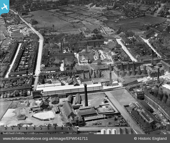
EPW041711 ENGLAND (1933). The Campbell Tile Works alongside the Newcastle Under Lyme Canal, Stoke-on-Trent, 1933
© Copyright OpenStreetMap contributors and licensed by the OpenStreetMap Foundation. 2024. Cartography is licensed as CC BY-SA.
Nearby Images (48)
Details
| Title | [EPW041711] The Campbell Tile Works alongside the Newcastle Under Lyme Canal, Stoke-on-Trent, 1933 |
| Reference | EPW041711 |
| Date | June-1933 |
| Link | |
| Place name | STOKE-ON-TRENT |
| Parish | |
| District | |
| Country | ENGLAND |
| Easting / Northing | 387497, 344837 |
| Longitude / Latitude | -2.1863247845605, 53.000399380382 |
| National Grid Reference | SJ875448 |
Pins
Be the first to add a comment to this image!


![[EPW041711] The Campbell Tile Works alongside the Newcastle Under Lyme Canal, Stoke-on-Trent, 1933](http://britainfromabove.org.uk/sites/all/libraries/aerofilms-images/public/100x100/EPW/041/EPW041711.jpg)
![[EPW055676] The Campbell Tile Works, Stoke-on-Trent, 1937](http://britainfromabove.org.uk/sites/all/libraries/aerofilms-images/public/100x100/EPW/055/EPW055676.jpg)
![[EAW018080] The Campbell Tile Works, Stoke-on-Trent, 1948. This image was marked by Aerofilms Ltd for photo editing.](http://britainfromabove.org.uk/sites/all/libraries/aerofilms-images/public/100x100/EAW/018/EAW018080.jpg)
![[EPW046752] The Campbell Tile Company Tile Works and environs, Stoke-on-Trent, 1935](http://britainfromabove.org.uk/sites/all/libraries/aerofilms-images/public/100x100/EPW/046/EPW046752.jpg)
![[EPW041802] Potteries and Tile Works either side of the London Road, Stoke-on-Trent, 1933](http://britainfromabove.org.uk/sites/all/libraries/aerofilms-images/public/100x100/EPW/041/EPW041802.jpg)
![[EAW018086] The Campbell Tile Works, Stoke-on-Trent, 1948. This image was marked by Aerofilms Ltd for photo editing.](http://britainfromabove.org.uk/sites/all/libraries/aerofilms-images/public/100x100/EAW/018/EAW018086.jpg)
![[EPW036091] The Campbell Tile Works and environs, Boothen, 1931](http://britainfromabove.org.uk/sites/all/libraries/aerofilms-images/public/100x100/EPW/036/EPW036091.jpg)
![[EPW055675] The Campbell Tile Works, Stoke-on-Trent, 1937](http://britainfromabove.org.uk/sites/all/libraries/aerofilms-images/public/100x100/EPW/055/EPW055675.jpg)
![[EPW036089] The Campbell Tile Works, London Road and environs, Boothen, 1931](http://britainfromabove.org.uk/sites/all/libraries/aerofilms-images/public/100x100/EPW/036/EPW036089.jpg)
![[EPW041712] The Campbell Tile Works, Stoke-on-Trent, 1933](http://britainfromabove.org.uk/sites/all/libraries/aerofilms-images/public/100x100/EPW/041/EPW041712.jpg)
![[EPW055680] The Campbell Tile Works, Stoke-on-Trent, 1937](http://britainfromabove.org.uk/sites/all/libraries/aerofilms-images/public/100x100/EPW/055/EPW055680.jpg)
![[EAW018081] The Campbell Tile Works, Stoke-on-Trent, 1948. This image was marked by Aerofilms Ltd for photo editing.](http://britainfromabove.org.uk/sites/all/libraries/aerofilms-images/public/100x100/EAW/018/EAW018081.jpg)
![[EPW055683] The Campbell Tile Works, Stoke-on-Trent, 1937](http://britainfromabove.org.uk/sites/all/libraries/aerofilms-images/public/100x100/EPW/055/EPW055683.jpg)
![[EPW055682] The Campbell Tile Works, Stoke-on-Trent, 1937](http://britainfromabove.org.uk/sites/all/libraries/aerofilms-images/public/100x100/EPW/055/EPW055682.jpg)
![[EAW046224] London Road and the Campbell Tile Works, Stoke-on-Trent, 1952. This image was marked by Aerofilms Ltd for photo editing.](http://britainfromabove.org.uk/sites/all/libraries/aerofilms-images/public/100x100/EAW/046/EAW046224.jpg)
![[EPW046757] The Campbell Tile Company Tile Works and environs, Stoke-on-Trent, 1935](http://britainfromabove.org.uk/sites/all/libraries/aerofilms-images/public/100x100/EPW/046/EPW046757.jpg)
![[EPW041710] The Campbell Tile Works, Stoke-on-Trent, 1933](http://britainfromabove.org.uk/sites/all/libraries/aerofilms-images/public/100x100/EPW/041/EPW041710.jpg)
![[EAW018088] London Road and the Campbell Tile Works, Stoke-on-Trent, 1948. This image was marked by Aerofilms Ltd for photo editing.](http://britainfromabove.org.uk/sites/all/libraries/aerofilms-images/public/100x100/EAW/018/EAW018088.jpg)
![[EPW046756] The Campbell Tile Company Tile Works and environs, Stoke-on-Trent, 1935](http://britainfromabove.org.uk/sites/all/libraries/aerofilms-images/public/100x100/EPW/046/EPW046756.jpg)
![[EPW055678] The Campbell Tile Works, Stoke-on-Trent, 1937](http://britainfromabove.org.uk/sites/all/libraries/aerofilms-images/public/100x100/EPW/055/EPW055678.jpg)
![[EAW046217] The Campbell Tile Works, Stoke-on-Trent, 1952. This image was marked by Aerofilms Ltd for photo editing.](http://britainfromabove.org.uk/sites/all/libraries/aerofilms-images/public/100x100/EAW/046/EAW046217.jpg)
![[EPW036093] The Campbell Tile Works, Newcastle Under Lyme Canal and environs, Boothen, 1931](http://britainfromabove.org.uk/sites/all/libraries/aerofilms-images/public/100x100/EPW/036/EPW036093.jpg)
![[EPW041714] The Campbell Tile Works, Stoke-on-Trent, 1933](http://britainfromabove.org.uk/sites/all/libraries/aerofilms-images/public/100x100/EPW/041/EPW041714.jpg)
![[EPW036094] The Campbell Tile Works and environs, Boothen, 1931](http://britainfromabove.org.uk/sites/all/libraries/aerofilms-images/public/100x100/EPW/036/EPW036094.jpg)
![[EAW046219] London Road and the Campbell Tile Works, Stoke-on-Trent, 1952. This image was marked by Aerofilms Ltd for photo editing.](http://britainfromabove.org.uk/sites/all/libraries/aerofilms-images/public/100x100/EAW/046/EAW046219.jpg)
![[EAW046222] Penkhull New Road and the Campbell Tile Works, Stoke-on-Trent, 1952. This image was marked by Aerofilms Ltd for photo editing.](http://britainfromabove.org.uk/sites/all/libraries/aerofilms-images/public/100x100/EAW/046/EAW046222.jpg)
![[EPW036090] The Campbell Tile Works and environs, Boothen, 1931](http://britainfromabove.org.uk/sites/all/libraries/aerofilms-images/public/100x100/EPW/036/EPW036090.jpg)
![[EAW018087] The Campbell Tile Works, Stoke-on-Trent, 1948](http://britainfromabove.org.uk/sites/all/libraries/aerofilms-images/public/100x100/EAW/018/EAW018087.jpg)
![[EAW046221] London Road and the Campbell Tile Works, Stoke-on-Trent, 1952. This image was marked by Aerofilms Ltd for photo editing.](http://britainfromabove.org.uk/sites/all/libraries/aerofilms-images/public/100x100/EAW/046/EAW046221.jpg)
![[EAW046215] The Campbell Tile Works, Crescent Potteries and environs, Stoke-on-Trent, 1952. This image was marked by Aerofilms Ltd for photo editing.](http://britainfromabove.org.uk/sites/all/libraries/aerofilms-images/public/100x100/EAW/046/EAW046215.jpg)
![[EAW046216] The Campbell Tile Works and environs, Stoke-on-Trent, 1952. This image was marked by Aerofilms Ltd for photo editing.](http://britainfromabove.org.uk/sites/all/libraries/aerofilms-images/public/100x100/EAW/046/EAW046216.jpg)
![[EAW046223] The Campbell Tile Works, Stoke-on-Trent, 1952. This image was marked by Aerofilms Ltd for photo editing.](http://britainfromabove.org.uk/sites/all/libraries/aerofilms-images/public/100x100/EAW/046/EAW046223.jpg)
![[EAW018079] The Campbell Tile Works, Stoke-on-Trent, 1948. This image has been produced from a print marked by Aerofilms Ltd for photo editing.](http://britainfromabove.org.uk/sites/all/libraries/aerofilms-images/public/100x100/EAW/018/EAW018079.jpg)
![[EPW046753] The Campbell Tile Company Tile Works and environs, Stoke-on-Trent, 1935](http://britainfromabove.org.uk/sites/all/libraries/aerofilms-images/public/100x100/EPW/046/EPW046753.jpg)
![[EAW046213] The Campbell Tile Works and environs, Stoke-on-Trent, 1952. This image was marked by Aerofilms Ltd for photo editing.](http://britainfromabove.org.uk/sites/all/libraries/aerofilms-images/public/100x100/EAW/046/EAW046213.jpg)
![[EAW018084] The Campbell Tile Works, Stoke-on-Trent, 1948. This image has been produced from a damaged negative.](http://britainfromabove.org.uk/sites/all/libraries/aerofilms-images/public/100x100/EAW/018/EAW018084.jpg)
![[EAW046220] London Road and the Campbell Tile Works, Stoke-on-Trent, 1952. This image was marked by Aerofilms Ltd for photo editing.](http://britainfromabove.org.uk/sites/all/libraries/aerofilms-images/public/100x100/EAW/046/EAW046220.jpg)
![[EPW046754] The Campbell Tile Company Tile Works and environs, Stoke-on-Trent, 1935](http://britainfromabove.org.uk/sites/all/libraries/aerofilms-images/public/100x100/EPW/046/EPW046754.jpg)
![[EPW046755] The Campbell Tile Company Tile Works and environs, Stoke-on-Trent, 1935](http://britainfromabove.org.uk/sites/all/libraries/aerofilms-images/public/100x100/EPW/046/EPW046755.jpg)
![[EAW046218] The Campbell Tile Works, Stoke-on-Trent, 1952. This image was marked by Aerofilms Ltd for photo editing.](http://britainfromabove.org.uk/sites/all/libraries/aerofilms-images/public/100x100/EAW/046/EAW046218.jpg)
![[EAW038494] The Kirkhams Ltd Earthenware Factory, Stoke-on-Trent, 1951. This image has been produced from a print marked by Aerofilms Ltd for photo editing.](http://britainfromabove.org.uk/sites/all/libraries/aerofilms-images/public/100x100/EAW/038/EAW038494.jpg)
![[EAW038497] The Kirkhams Ltd Earthenware Factory, Stoke-on-Trent, 1951. This image has been produced from a print marked by Aerofilms Ltd for photo editing.](http://britainfromabove.org.uk/sites/all/libraries/aerofilms-images/public/100x100/EAW/038/EAW038497.jpg)
![[EAW046079] The Campbell Tile Works and London Road, Stoke-on-Trent, 1952](http://britainfromabove.org.uk/sites/all/libraries/aerofilms-images/public/100x100/EAW/046/EAW046079.jpg)
![[EAW038499] The Kirkhams Ltd Earthenware Factory, Stoke-on-Trent, 1951. This image has been produced from a print marked by Aerofilms Ltd for photo editing.](http://britainfromabove.org.uk/sites/all/libraries/aerofilms-images/public/100x100/EAW/038/EAW038499.jpg)
![[EAW038493] The Kirkhams Ltd Earthenware Factory and environs, Stoke-on-Trent, 1951. This image has been produced from a print marked by Aerofilms Ltd for photo editing.](http://britainfromabove.org.uk/sites/all/libraries/aerofilms-images/public/100x100/EAW/038/EAW038493.jpg)
![[EAW038496] The Kirkhams Ltd Earthenware Factory, Stoke-on-Trent, 1951. This image has been produced from a print marked by Aerofilms Ltd for photo editing.](http://britainfromabove.org.uk/sites/all/libraries/aerofilms-images/public/100x100/EAW/038/EAW038496.jpg)
![[EAW038495] The Kirkhams Ltd Earthenware Factory and environs, Stoke-on-Trent, 1951. This image has been produced from a print marked by Aerofilms Ltd for photo editing.](http://britainfromabove.org.uk/sites/all/libraries/aerofilms-images/public/100x100/EAW/038/EAW038495.jpg)
![[EPW041799] The city centre, Stoke-on-Trent, from the south-west, 1933](http://britainfromabove.org.uk/sites/all/libraries/aerofilms-images/public/100x100/EPW/041/EPW041799.jpg)