
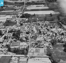
EPW031763 ENGLAND (1930). St Mary's Church and the town centre, Mildenhall, 1930

© Copyright OpenStreetMap contributors and licensed by the OpenStreetMap Foundation. 2025. Cartography is licensed as CC BY-SA.
Details
| Title | [EPW031763] St Mary's Church and the town centre, Mildenhall, 1930 |
| Reference | EPW031763 |
| Date | April-1930 |
| Link | |
| Place name | MILDENHALL |
| Parish | MILDENHALL |
| District | |
| Country | ENGLAND |
| Easting / Northing | 571043, 274592 |
| Longitude / Latitude | 0.51114232070386, 52.342306243067 |
| National Grid Reference | TL710746 |
Pins
 David960 |
Wednesday 13th of April 2016 10:50:57 AM | |
Where's Canning Town? |
Wednesday 12th of February 2014 06:45:17 PM |
User Comment Contributions
 The Manor House in the centre of Mildenhall, Suffolk; just to the North of the church. It was demolished in 1934. Combination of the family diminishing and high land value. |
Where's Canning Town? |
Wednesday 12th of February 2014 06:39:56 PM |