
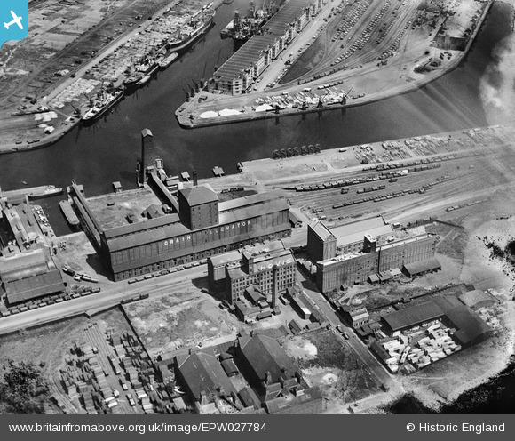
EPW027784 ENGLAND (1929). The Hovis flour mills and Grain Elevator alongside the Manchester Ship Canal, Old Trafford, 1929
© Copyright OpenStreetMap contributors and licensed by the OpenStreetMap Foundation. 2024. Cartography is licensed as CC BY-SA.
Nearby Images (21)
EPW027784

EAW017318

EAW044198
 Flour and Provender Mill, Trafford Park, 1952. This image was marked by Aerofilms Ltd for photo editing.")
EAW044199
 Flour and Provender Mill, Trafford Park, 1952. This image was marked by Aerofilms Ltd for photo editing.")
EAW044200
 Flour and Provender Mill, Trafford Park, 1952. This image was marked by Aerofilms Ltd for photo editing.")
EAW044193
 Flour and Provender Mill, Trafford Park, 1952. This image was marked by Aerofilms Ltd for photo editing.")
EAW044197
 Flour and Provender Mill, Trafford Park, 1952. This image was marked by Aerofilms Ltd for photo editing.")
EAW044196
 Flour and Provender Mill, Trafford Park, 1952. This image was marked by Aerofilms Ltd for photo editing.")
EAW044195
 Flour and Provender Mill and surrounding Saw Mills, Trafford Park, 1952. This image was marked by Aerofilms Ltd for photo editing.")
EAW044194
 Flour and Provender Mill and surrounding Saw Mills, Trafford Park, 1952. This image was marked by Aerofilms Ltd for photo editing.")
EAW017317

EAW017316

EAW017319

EAW017320

EAW017315

EAW017314

EPW027854

EPW028013

EPW028012

EPW028011

EAW050418

Details
| Title | [EPW027784] The Hovis flour mills and Grain Elevator alongside the Manchester Ship Canal, Old Trafford, 1929 |
| Reference | EPW027784 |
| Date | June-1929 |
| Link | |
| Place name | OLD TRAFFORD |
| Parish | |
| District | |
| Country | ENGLAND |
| Easting / Northing | 380260, 396982 |
| Longitude / Latitude | -2.2974034732116, 53.46895163162 |
| National Grid Reference | SJ803970 |
Pins
Be the first to add a comment to this image!


