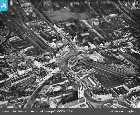
EPW025119 ENGLAND (1928). Broadway and environs, Hammersmith, 1928. This image has been produced from a copy-negative.
© Copyright OpenStreetMap contributors and licensed by the OpenStreetMap Foundation. 2025. Cartography is licensed as CC BY-SA.
Nearby Images (13)
Details
| Title | [EPW025119] Broadway and environs, Hammersmith, 1928. This image has been produced from a copy-negative. |
| Reference | EPW025119 |
| Date | October-1928 |
| Link | |
| Place name | HAMMERSMITH |
| Parish | |
| District | |
| Country | ENGLAND |
| Easting / Northing | 523373, 178638 |
| Longitude / Latitude | -0.22266591284442, 51.492723941329 |
| National Grid Reference | TQ234786 |
Pins
 Leslie B |
Monday 22nd of August 2022 05:09:45 PM | |
 Leslie B |
Monday 22nd of August 2022 05:08:29 PM | |
 Leslie B |
Monday 22nd of August 2022 05:02:22 PM | |
 Leslie B |
Monday 22nd of August 2022 05:01:12 PM | |
 Class31 |
Thursday 14th of April 2016 01:43:02 PM | |
 Class31 |
Thursday 14th of April 2016 01:41:01 PM | |
 Des Elmes |
Thursday 14th of April 2016 01:36:26 PM | |
 Leslie B |
Tuesday 22nd of March 2016 12:15:59 AM | |
 The Laird |
Sunday 14th of June 2015 01:00:52 PM | |
 The Laird |
Sunday 14th of June 2015 01:00:08 PM | |
 The Laird |
Sunday 14th of June 2015 12:59:36 PM | |
 The Laird |
Sunday 14th of June 2015 12:59:14 PM |


![[EPW025119] Broadway and environs, Hammersmith, 1928. This image has been produced from a copy-negative.](http://britainfromabove.org.uk/sites/all/libraries/aerofilms-images/public/100x100/EPW/025/EPW025119.jpg)
![[EPR000469] Broadway, Hammersmith, 1935](http://britainfromabove.org.uk/sites/all/libraries/aerofilms-images/public/100x100/EPR/000/EPR000469.jpg)
![[EPW034908] St Paul's Church, the Convent and School of the Sacred Heart, the West London Hospital and environs, Hammersmith, 1931](http://britainfromabove.org.uk/sites/all/libraries/aerofilms-images/public/100x100/EPW/034/EPW034908.jpg)
![[EPW057072] The Broadway and environs, Hammersmith, 1938](http://britainfromabove.org.uk/sites/all/libraries/aerofilms-images/public/100x100/EPW/057/EPW057072.jpg)
![[EPW034903] Hammersmith Broadway, Hammersmith Railway Station, the West London Hospital and environs, Hammersmith, 1931](http://britainfromabove.org.uk/sites/all/libraries/aerofilms-images/public/100x100/EPW/034/EPW034903.jpg)
![[EPW034906] Hammersmith Broadway, the Convent and School of the Sacred Heart, the West London Hospital and environs, Hammersmith, 1931](http://britainfromabove.org.uk/sites/all/libraries/aerofilms-images/public/100x100/EPW/034/EPW034906.jpg)
![[EPW034909] Hammersmith Railway Station, the Convent and School of the Sacred Heart, the West London Hospital and environs, Hammersmith, 1931](http://britainfromabove.org.uk/sites/all/libraries/aerofilms-images/public/100x100/EPW/034/EPW034909.jpg)
![[EPW034905] Hammersmith Railway Station, the Convent and School of the Sacred Heart, the West London Hospital and environs, Hammersmith, 1931](http://britainfromabove.org.uk/sites/all/libraries/aerofilms-images/public/100x100/EPW/034/EPW034905.jpg)
![[EPW034904] Hammersmith Road, the West London Hospital and environs, Hammersmith, 1931](http://britainfromabove.org.uk/sites/all/libraries/aerofilms-images/public/100x100/EPW/034/EPW034904.jpg)
![[EPW034907] Hammersmith Railway Station, the Convent and School of the Sacred Heart, the West London Hospital and environs, Hammersmith, 1931](http://britainfromabove.org.uk/sites/all/libraries/aerofilms-images/public/100x100/EPW/034/EPW034907.jpg)
![[EPW034910] The Convent and School of the Sacred Heart, the West London Hospital and environs, Hammersmith, 1931](http://britainfromabove.org.uk/sites/all/libraries/aerofilms-images/public/100x100/EPW/034/EPW034910.jpg)
![[EPW034911] Hammersmith Broadway, the Convent and School of the Sacred Heart, the West London Hospital and environs, Hammersmith, 1931](http://britainfromabove.org.uk/sites/all/libraries/aerofilms-images/public/100x100/EPW/034/EPW034911.jpg)
![[EPR000465] St Paul's Church and the Gaumont Palace, Hammersmith, 1935](http://britainfromabove.org.uk/sites/all/libraries/aerofilms-images/public/100x100/EPR/000/EPR000465.jpg)
