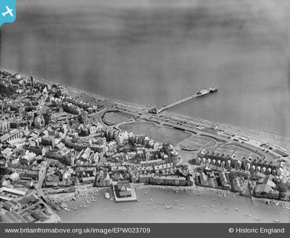
EPW023709 ENGLAND (1928). The Den and the Pier, Teignmouth, 1928
© Copyright OpenStreetMap contributors and licensed by the OpenStreetMap Foundation. 2024. Cartography is licensed as CC BY-SA.
Nearby Images (15)
Details
| Title | [EPW023709] The Den and the Pier, Teignmouth, 1928 |
| Reference | EPW023709 |
| Date | September-1928 |
| Link | |
| Place name | TEIGNMOUTH |
| Parish | TEIGNMOUTH |
| District | |
| Country | ENGLAND |
| Easting / Northing | 294221, 72741 |
| Longitude / Latitude | -3.493074407225, 50.544262955147 |
| National Grid Reference | SX942727 |


![[EPW023709] The Den and the Pier, Teignmouth, 1928](http://britainfromabove.org.uk/sites/all/libraries/aerofilms-images/public/100x100/EPW/023/EPW023709.jpg)
![[EPW033440] Teignmouth Pier, the seafront and the town centre, Teignmouth, 1930. This image has been produced from a damaged negative.](http://britainfromabove.org.uk/sites/all/libraries/aerofilms-images/public/100x100/EPW/033/EPW033440.jpg)
![[EPW039710] The Den, Teignmouth Pier and the town, Teignmouth, 1932](http://britainfromabove.org.uk/sites/all/libraries/aerofilms-images/public/100x100/EPW/039/EPW039710.jpg)
![[EPW023760] Teignmouth Pier and Spratt Sand, Teignmouth, 1928](http://britainfromabove.org.uk/sites/all/libraries/aerofilms-images/public/100x100/EPW/023/EPW023760.jpg)
![[EPW039712] The beach, Teignmouth Pier and the town, Teignmouth, 1932](http://britainfromabove.org.uk/sites/all/libraries/aerofilms-images/public/100x100/EPW/039/EPW039712.jpg)
![[EPW024205] Teignmouth Pier, Teignmouth, 1928](http://britainfromabove.org.uk/sites/all/libraries/aerofilms-images/public/100x100/EPW/024/EPW024205.jpg)
![[EPW024183] Courtenay Place, The Den and environs, Teignmouth, 1928](http://britainfromabove.org.uk/sites/all/libraries/aerofilms-images/public/100x100/EPW/024/EPW024183.jpg)
![[EPW033434] Teignmouth Pier, The Den and the town, Teignmouth, 1930](http://britainfromabove.org.uk/sites/all/libraries/aerofilms-images/public/100x100/EPW/033/EPW033434.jpg)
![[EPW039711] The Den, Teignmouth Pier and the beach, Teignmouth, 1932](http://britainfromabove.org.uk/sites/all/libraries/aerofilms-images/public/100x100/EPW/039/EPW039711.jpg)
![[EPW033435] Teignmouth Pier and the town, Teignmouth, from the south-east, 1930](http://britainfromabove.org.uk/sites/all/libraries/aerofilms-images/public/100x100/EPW/033/EPW033435.jpg)
![[EPW023708] The Den and the Pier, Teignmouth, 1928](http://britainfromabove.org.uk/sites/all/libraries/aerofilms-images/public/100x100/EPW/023/EPW023708.jpg)
![[EPW033439] Teignmouth Railway Station, St Michael's Church and Regent Street, Teignmouth, 1930](http://britainfromabove.org.uk/sites/all/libraries/aerofilms-images/public/100x100/EPW/033/EPW033439.jpg)
![[EPW039709] The Den, Teignmouth Pier and the town, Teignmouth, 1932](http://britainfromabove.org.uk/sites/all/libraries/aerofilms-images/public/100x100/EPW/039/EPW039709.jpg)
![[EPW033437] The New Quay, The Den and the town, Teignmouth, 1930](http://britainfromabove.org.uk/sites/all/libraries/aerofilms-images/public/100x100/EPW/033/EPW033437.jpg)
![[EPW024182] St Michael's Church and the Promenade, Teignmouth, 1928](http://britainfromabove.org.uk/sites/all/libraries/aerofilms-images/public/100x100/EPW/024/EPW024182.jpg)

