
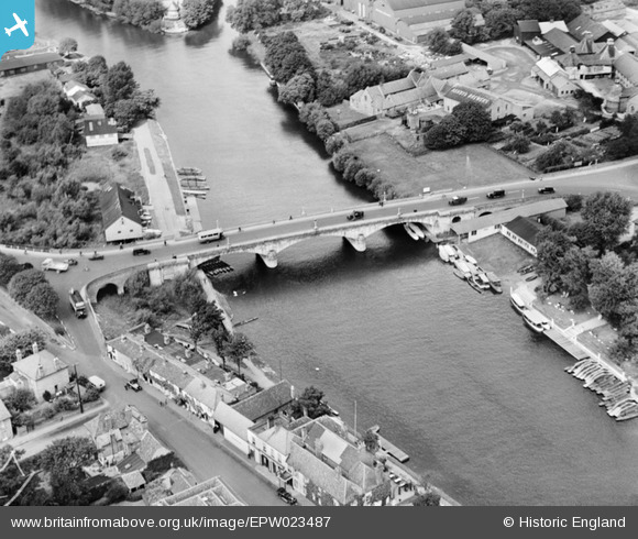
EPW023487 ENGLAND (1928). Staines Bridge and Ashby's Brewery, Staines, 1928
© Copyright OpenStreetMap contributors and licensed by the OpenStreetMap Foundation. 2024. Cartography is licensed as CC BY-SA.
Nearby Images (8)
EPW023487

EPW023493

EPW006219

EPW023492

EPW061673

EPW023483

EPW061670

EPW023484

Details
| Title | [EPW023487] Staines Bridge and Ashby's Brewery, Staines, 1928 |
| Reference | EPW023487 |
| Date | September-1928 |
| Link | |
| Place name | STAINES |
| Parish | |
| District | |
| Country | ENGLAND |
| Easting / Northing | 503204, 171530 |
| Longitude / Latitude | -0.51518436372737, 51.432868813979 |
| National Grid Reference | TQ032715 |
Pins
 MB |
Tuesday 2nd of April 2013 12:07:36 AM | |
This may have been the garage for vehicles of the guests of th adjoining Swan Hotel |
Graham Yaxley |
Monday 15th of December 2014 10:39:42 PM |
MB |
Tuesday 2nd of April 2013 12:02:10 AM | |
MB |
Monday 1st of April 2013 11:58:38 PM |
User Comment Contributions
 View west from Staines Bridge, 07/09/2015 |
 Class31 |
Tuesday 15th of September 2015 03:47:13 PM |
This is the fourth crossing of the Thames here since the wooden bridge was constructed in the thirteenth century. It was designed by George Rennie and built between 1827 and 1832. The structure is faced in white granite |
MB |
Tuesday 2nd of April 2013 12:06:23 AM |


